[ ]
]
[]

| GI-278 | Offshore Glaciolacustrine Deposits of Glacial Lake Agassiz: The Brenna Formation in Pembina County, North Dakota, Anderson, F.J., 2024. |
| GI-276 | Offshore Glaciolacustrine Deposits of Glacial Lake Agassiz: The Brenna Formation in Walsh County, North Dakota, Anderson, F.J., 2024. |
| GI-275 GIS Files | Opeche A Salt Extent and Thickness, Williston Basin, North Dakota, Chittick, S.D., 2024. |
| GI-274 White Bear Esterhazy | K2O Grades of the Potash-containing Members of the Prairie Formation, Garrison 100K Sheet, North Dakota. Kruger, N.W., 2023. |
| GI-273 Plate I Plate II Plate III | Offshore Glaciolacustrine Deposits of Glacial Lake Agassiz: The Brenna Formation in Cass County, North Dakota. Anderson, F.J., 2023. Available online. |
| GI-272 Appendix 1 Appendix 2 Appendix 3 Appendix 4 Appendix 5 Appendix 6 Plate 1 | Redevelopment of Madison Fields in Burke County Demonstrates Fracture Stimulation is Effective: Starns, E.C. and Nesheim, T.O., 2023. |
| GI-271 Plate I Plate II Plate III | Offshore Glaciolacustrine Deposits of Glacial Lake Agassiz: The Brenna Formation in Grand Forks County, North Dakota. Anderson, F.J., 2023. Available online. |
| GI-270 | Windblown Sand Resources in the Hazen East Quadrangle, Anderson, F.J., 2023. Available online. |
| GI-269 | Areas of Landslides in North Dakota: Anderson, F.J., Maike, C.A., Moxness, L.D., Murphy, E.C., Thapa, N., and York, B.C., 2023, 1:500,000 scale map. |
| GI-268 Mountrail Map Patience Lake Map Belle Plaine Map White Bear Map Esterhazy Map | K2O Grades of the Potash-containing Members of the Prairie Formation, Stanley 100K Sheet, North Dakota. Kruger, N.W., 2023. 5 map series. |
| GI-267 Charles A Salt Isopach Map Charles A Salt Project Summary Charles A Salt Top of Structure Map SSTVD Charles A Salt Top of Structure Map TVD Charles A Salt Well Data Charles A Salt Isopach Contour Shapefiles Charles A Salt Well Shapefiles | Charles A Salt Extent and Thickness, Williston Basin, North Dakota, Stolldorf, T.D., 2022 |
| GI-266 | Stratigraphic Framework of the Deadwood Formation, North Dakota, Bader, J.W., 2022. Available online. |
| GI-265 | Deadwood Formation (Cambrian / Ordovician) of North Dakota, A Core Atlas, Bader, J.W., Lake, J.H., Sarnoski, A.H., 2022. Available online. |
| GI-264 Pine Salt Isopach Map Pine Salt Project Summary Pine Salt Top of Structure Map SSTVD Pine Salt Top of Structure Map TVD Pine Salt Well Data Pine Salt Isopach Contour Shapefiles Pine Salt Well Shapefiles | Pine Salt Extent and Thickness, Williston Basin, North Dakota, Stolldorf, T.D., 2022 |
| GI-263 | Salt Isopach of the Devonian Prairie Formation, Killdeer 100K Sheet, North Dakota: Kruger, N.W., 2022. Available online. |
| GI-262 | Salt Isopach of the Devonian Prairie Formation, Grassy Butte 100K Sheet, North Dakota: Kruger, N.W., 2022. Available online. |
| GI-261 | Salt Isopach of the Devonian Prairie Formation, Watford City 100K Sheet, North Dakota: Kruger, N.W., 2022. Available online. |
| GI-260 | Salt Isopach of the Devonian Prairie Formation, Crosby 100K Sheet, North Dakota: Kruger, N.W., 2022. Available online. |
| GI-259 | Salt Isopach of the Devonian Prairie Formation, Hazen 100K Sheet, North Dakota: Kruger, N.W., 2022. Available online. |
| GI-258 Mountrail White Bear Esterhazy | K2O Grades of the Potash-containing Members of the Prairie Formation, Minot 100K Sheet, North Dakota. Kruger, N.W., 2021. 3 map series. |
| GI-257 | Deadwood Formation (Cambrian/Ordovician) of North Dakota, A Preliminary Core Atlas: Bader, J.W., Lake, J.H, Sarnoski, A.H. 2021. Available online |
| GI-256 Dunham Salt Isopach Map Dunham Salt Project Summary Dunham Salt Top of Structure Map Dunham Salt Well Data Dunham Salt Isopach Contour Shapefiles Dunham Salt Well Shapefiles | Dunham Salt Extent and Thickness, Williston Basin, North Dakota, Stolldorf, T.D. 2021 |
| GI-255 | Investigations into Petroleum Source Rocks within the Mississippian Madison Group: Bluell Subinterval of Western McKenzie County: Nesheim, T.O., 2021. Available online. Shape Files available by request. Shape files require GIS or other mapping related software to open. |
| GI-254 | Salt Isopach of the Devonian Prairie Formation, Williston 100K Sheet, North Dakota: Kruger, N.W., 2021. Available online. |
| GI-253 | Salt Isopach of the Devonian Prairie Formation, Kenmare 100K Sheet, North Dakota: Kruger, N.W., 2021. Available online. |
| GI-252 | Inyan Kara Sandstone Isopach Map, Hazen 100K Sheet, North Dakota, Stolldorf, T. D., 2021 |
| GI-251 | Assembling Laurentia Precambrian Compressional Tectonics in North Dakota and Surrounding Areas, Bader, J.W., 2021. |
| GI-250 | Inyan Kara Sandstone Isopach Map, Bowman 100K Sheet, North Dakota, Stolldorf, T. D., 2020 |
| GI-249 | Inyan Kara Sandstone Isopach Map, Dickinson 100K Sheet, North Dakota, Stolldorf, T. D., 2020 |
| GI-248 | Inyan Kara Sandstone Isopach Map, Belfield 100K Sheet, North Dakota, Stolldorf, T. D., 2020 |
| GI-247 Patience Lake Belle Plaine White Bear Esterhazy | K2O Grades of the Potash-containing Members of the Prairie Formation, Mohall 100K Sheet, North Dakota. Kruger, N.W., 2020. 4 map series. |
| GI-246 | Salt Isopach of the Devonian Prairie Formation, Mohall 100K Sheet, North Dakota: Kruger, N.W., 2020. Available online. |
| GI-245 | Evaluation of Water-Cut from Middle and Lower Three Forks Production (2nd and 3rd benches), Western North Dakota: Nesheim, T.O., 2020. Available online. |
| GI-244 | Preliminary Middle (2nd bench) and Lower (3rd and 4th bench) Three Forks Horizontal Well Identification: Nesheim, T.O., 2020. Available online. Shape Files available by request. Shape files require GIS or other mapping related software to open. |
| GI-243 | Mineralogy of Windblown Sand Deposits in McHenry County, North Dakota: Anderson, F.J., 2020. Available online. |
| GI-242 Summary and Well List Madison Group H2S Map Ratcliffe Interval H2S Map Frobisher-Alida Interval H2S Map Lodgepole H2S Map Duperow H2S Map Interlake H2S Map Stonewall-Gunton H2S Map Red River H2S Map Deadwood H2S Map |
Hydrogen Sulfide (H2S) Maps: Stolldorf, T.D., 2020 |
| GI-241 Summary DST Map Production Map Cum Prod Map Well List Madison-Spearfish Production Madison-Spearfish Cum Prod |
Spearfish Production and Drill Stem Test (DST) Maps: Stolldorf, T.D., 2020 |
| GI-240 Summary DST Map Production Map Cum Prod Map Well List |
Tyler Production and Drill Stem Test (DST) Maps: Stolldorf, T.D., 2020 |
| GI-239 Summary Madison Production Map Madison Cum Prod Map Ratcliffe DST Map Frobisher-Alida DST Map Lodgepole DST Map Lodgepole Production Map Lodgepole Cum Prod Map Madison Group Well List Lodgepole Well List Madison Unconformity DST Map Madison-Spearfish Production Madison-Spearfish Cum Prod |
Madison Group Production and Drill Stem Test (DST) Maps: Stolldorf, T.D., 2020 |
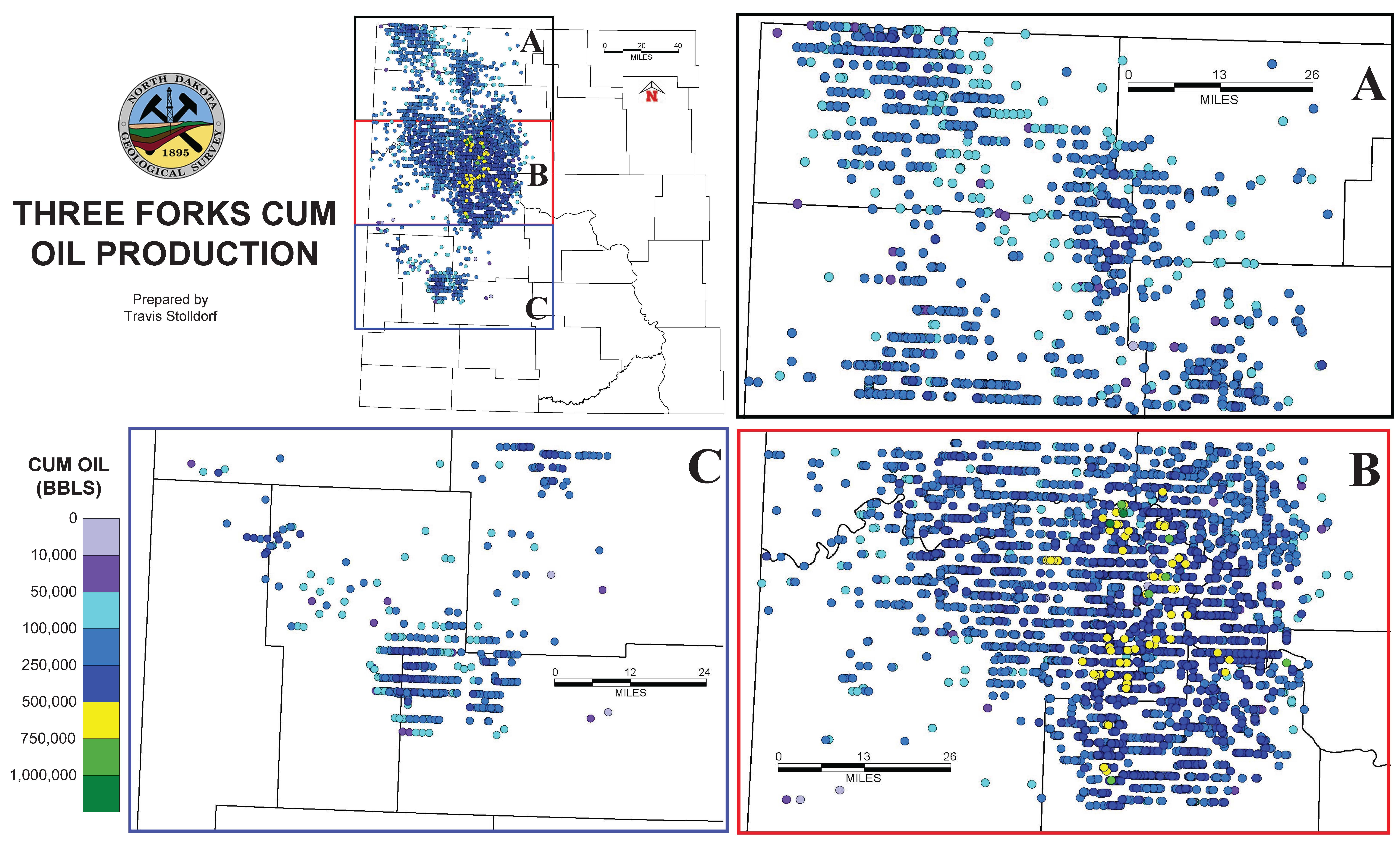
| GI-238 Summary BPS Production Map BPS Cum Prod Map Bakken DST Map Bakken Production Map Bakken Cum Prod Map Sanish DST Map Sanish Production Map Sanish Cum Prod Map Three Forks DST Map Three Forks Production Map Three Forks Cum Prod Map BPS Well List |
Bakken Petroleum System Production and Drill Stem Test (DST) Maps: Stolldorf, T.D., 2020 |
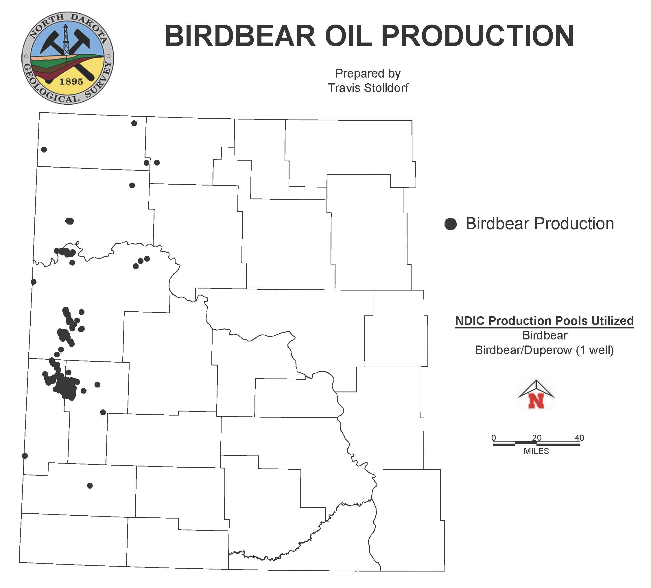
| GI-237 Summary DST Map Production Map Cum Prod Map Well List |
Birdbear Production and Drill Stem Test (DST) Maps: Stolldorf, T.D., 2020 |
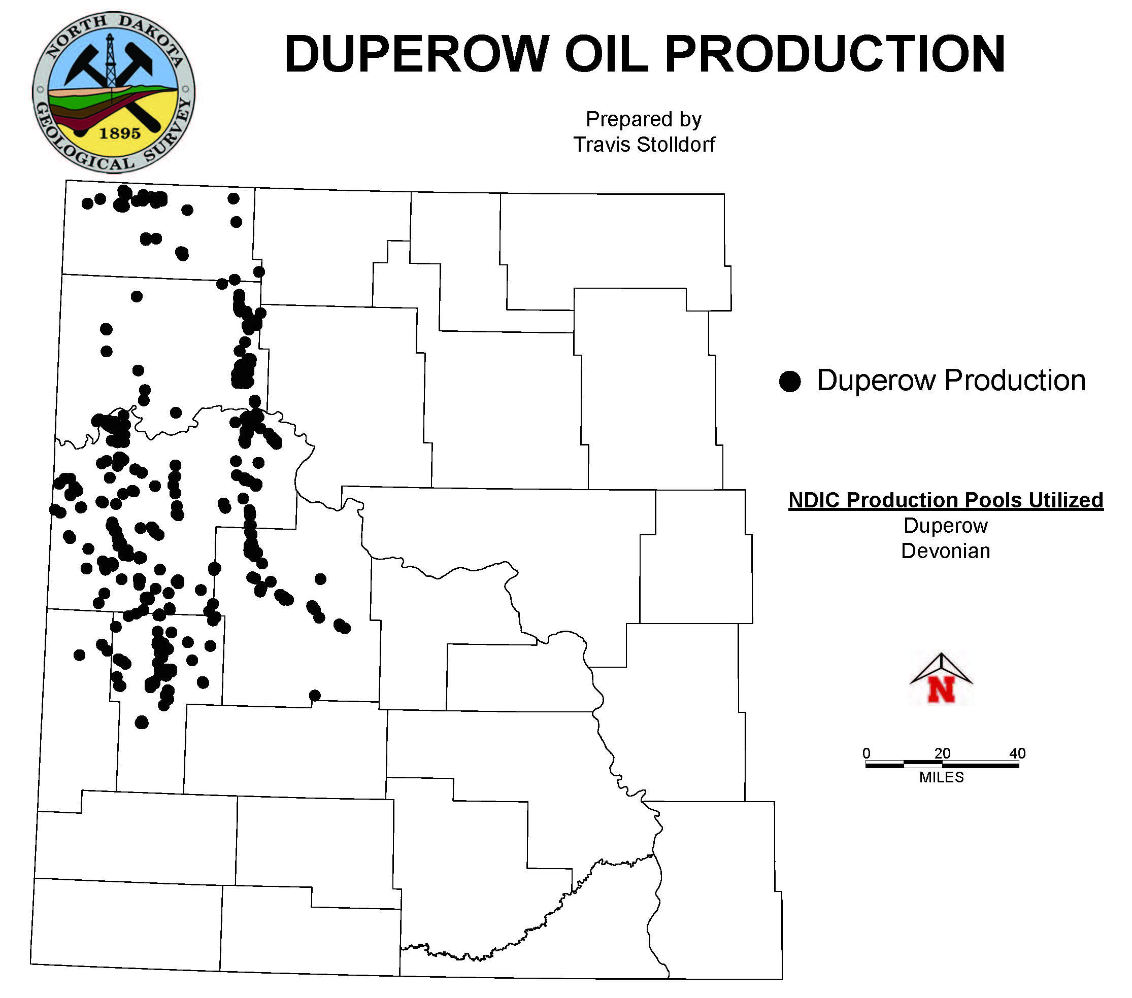
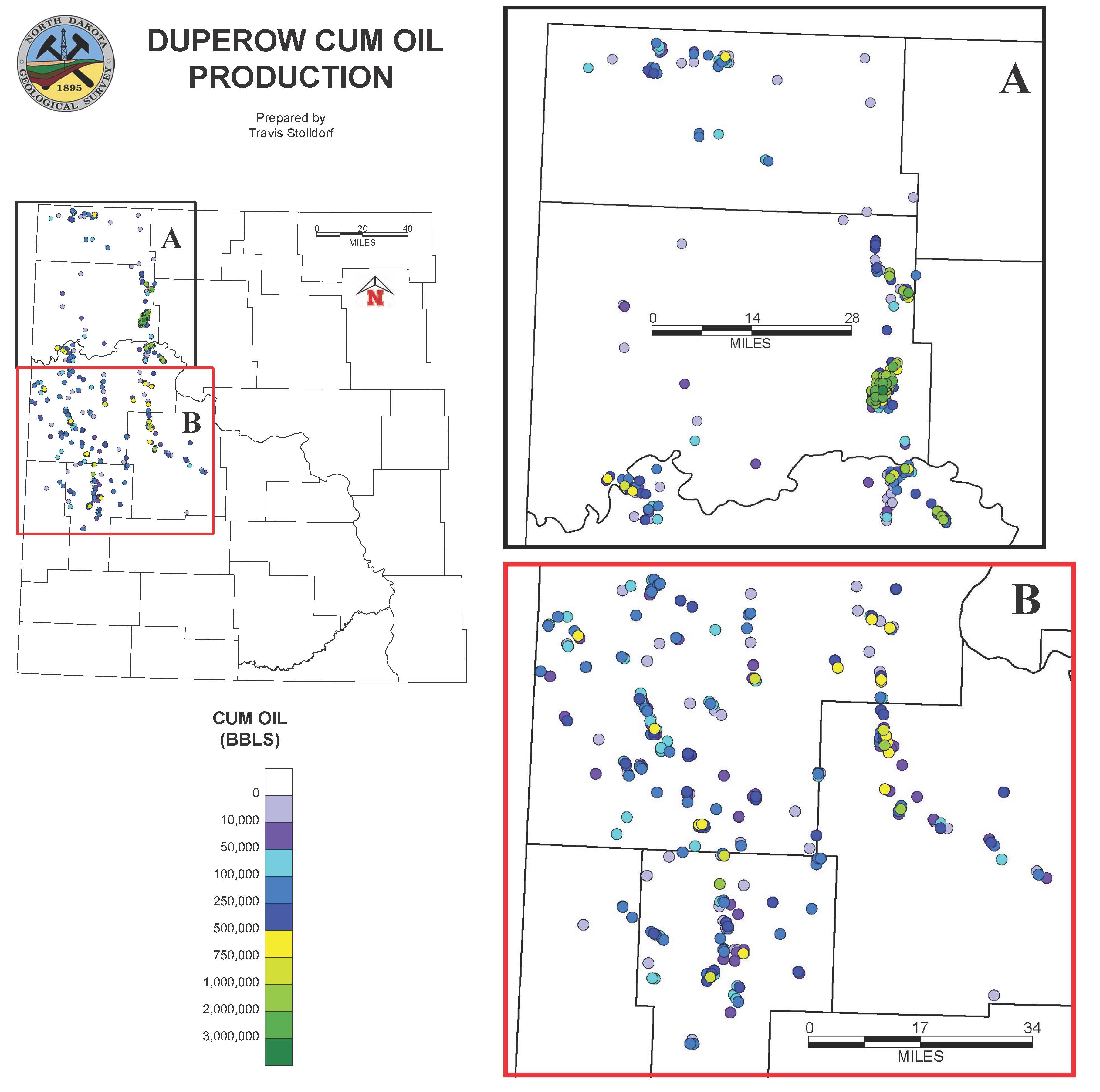
| GI-236 Summary DST Map Production Map Cum Prod Map Well List |
Duperow Production and Drill Stem Test (DST) Maps: Stolldorf, T.D., 2020 |
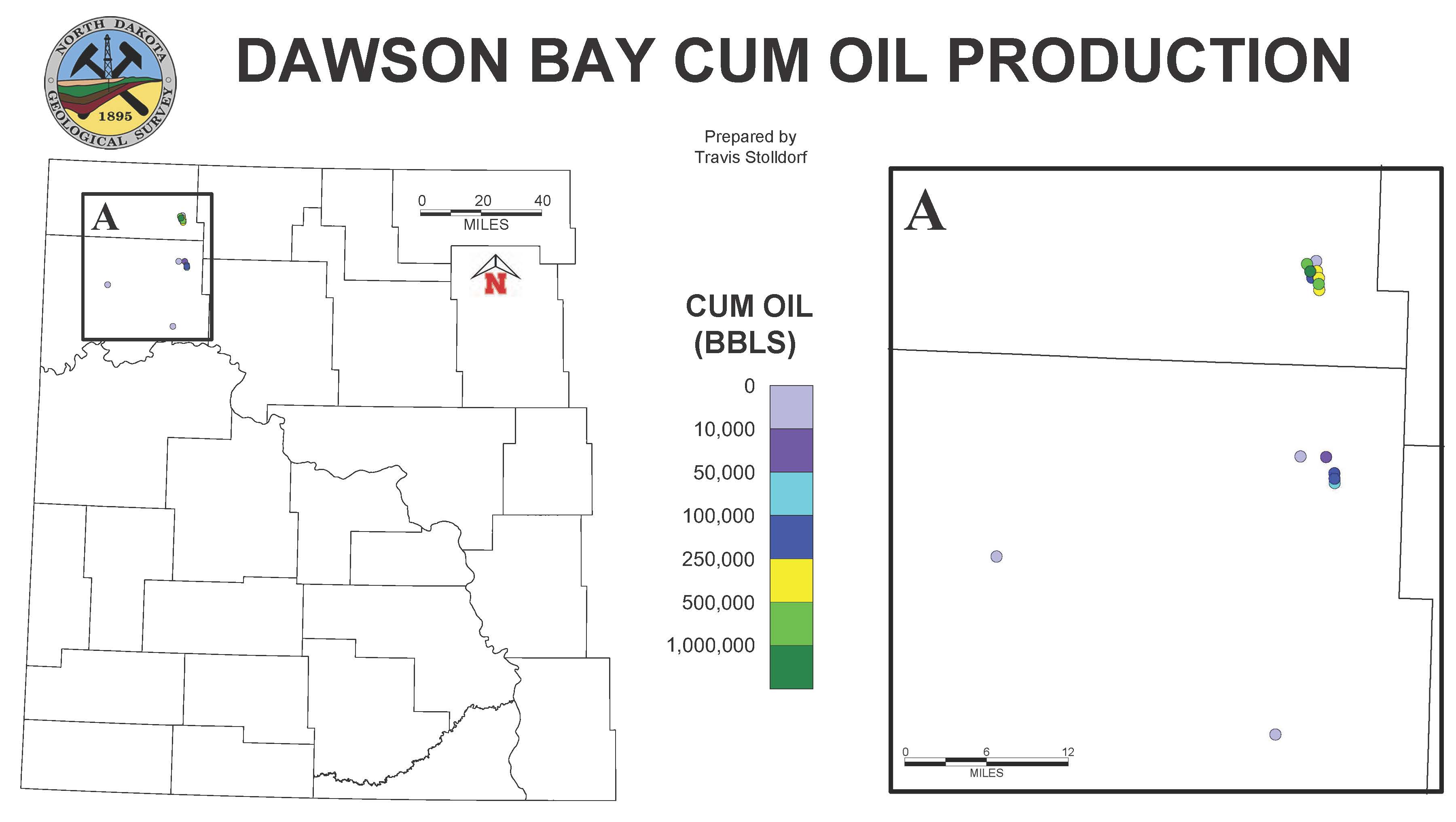
| GI-235 Summary DST Map Production Map Cum Prod Map Well List |
Dawson Bay Production and Drill Stem Test (DST) Maps: Stolldorf, T.D., 2020 |
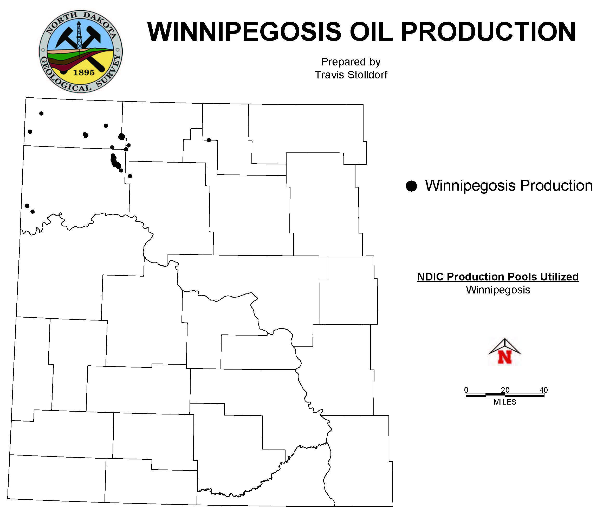
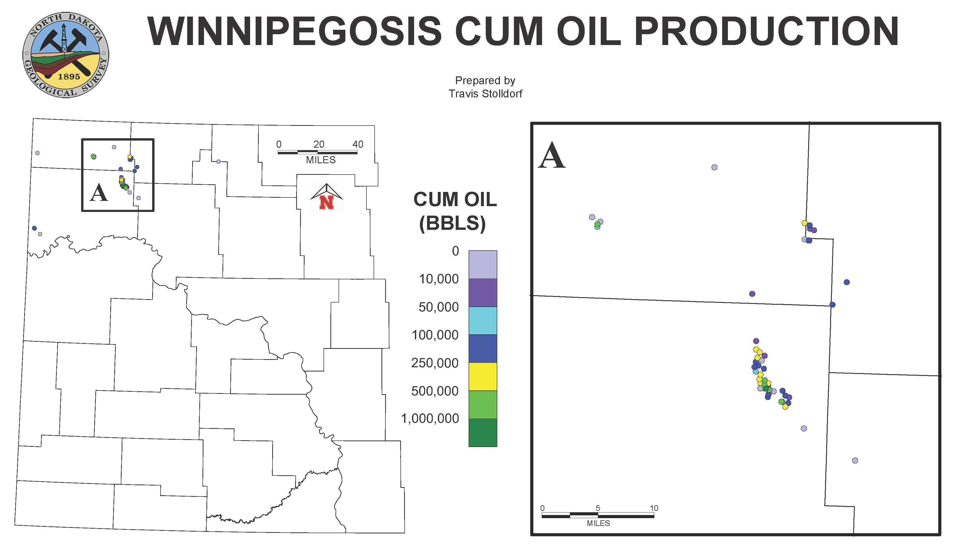
| GI-234 Summary DST Map Production Map Cum Prod Map Well List |
Winnipegosis Production and Drill Stem Test (DST) Maps: Stolldorf, T.D., 2020 |
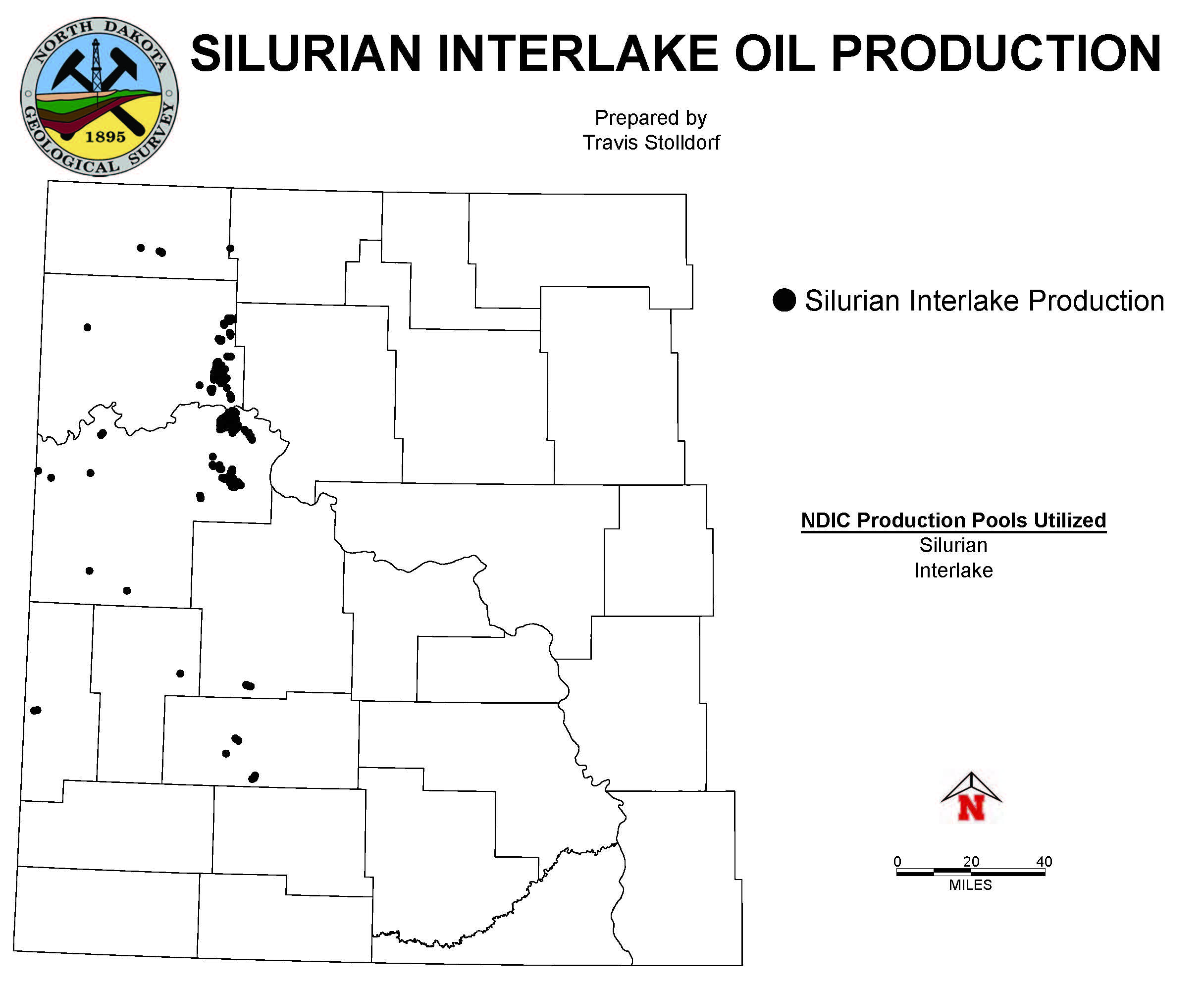
| GI-233 Summary DST Map Production Map Cum Prod Map Well List |
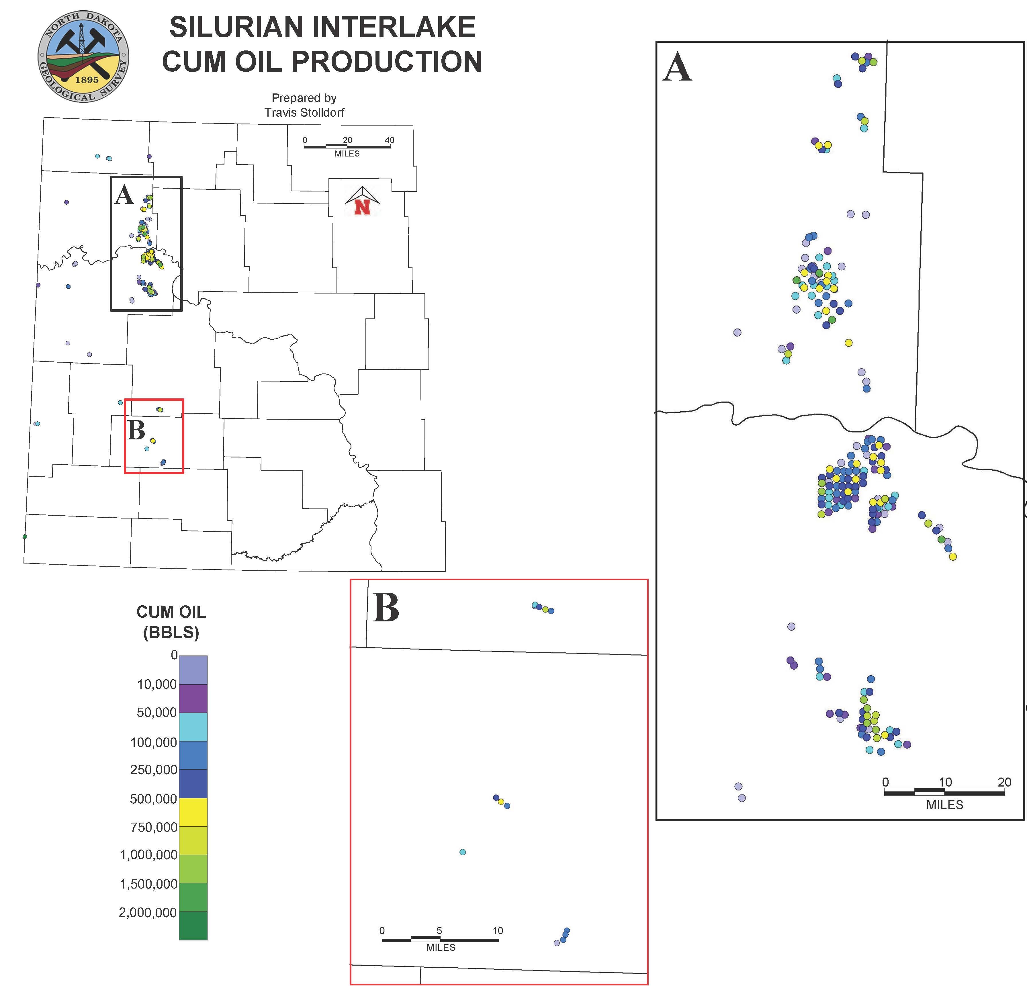
Interlake Production and Drill Stem Test (DST) Maps: Stolldorf, T.D., 2020 |
| GI-232 Summary DST Map Production Map Cum Prod Map Well List |
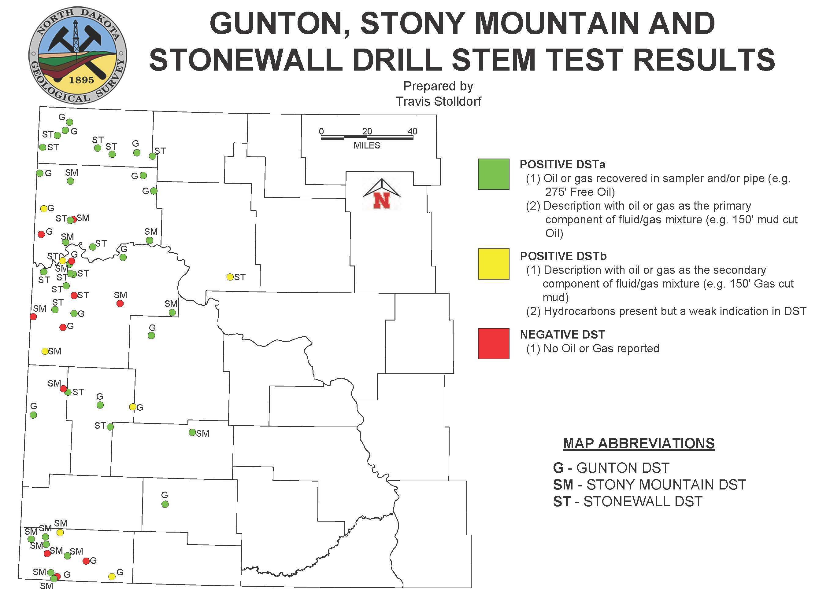
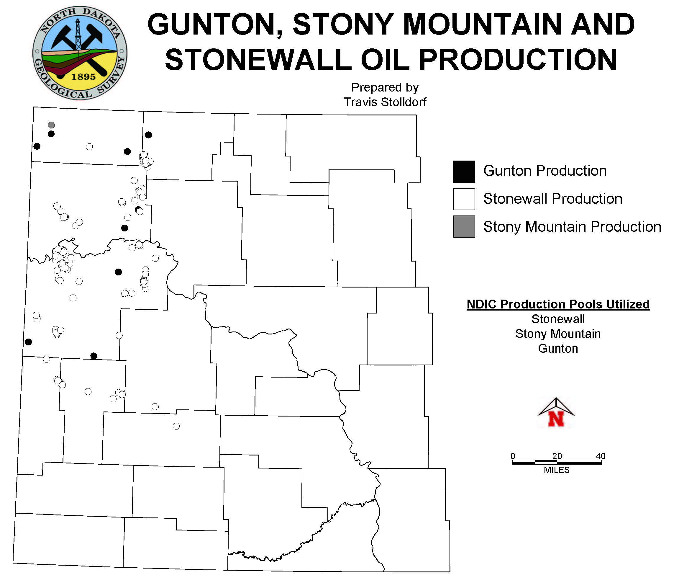
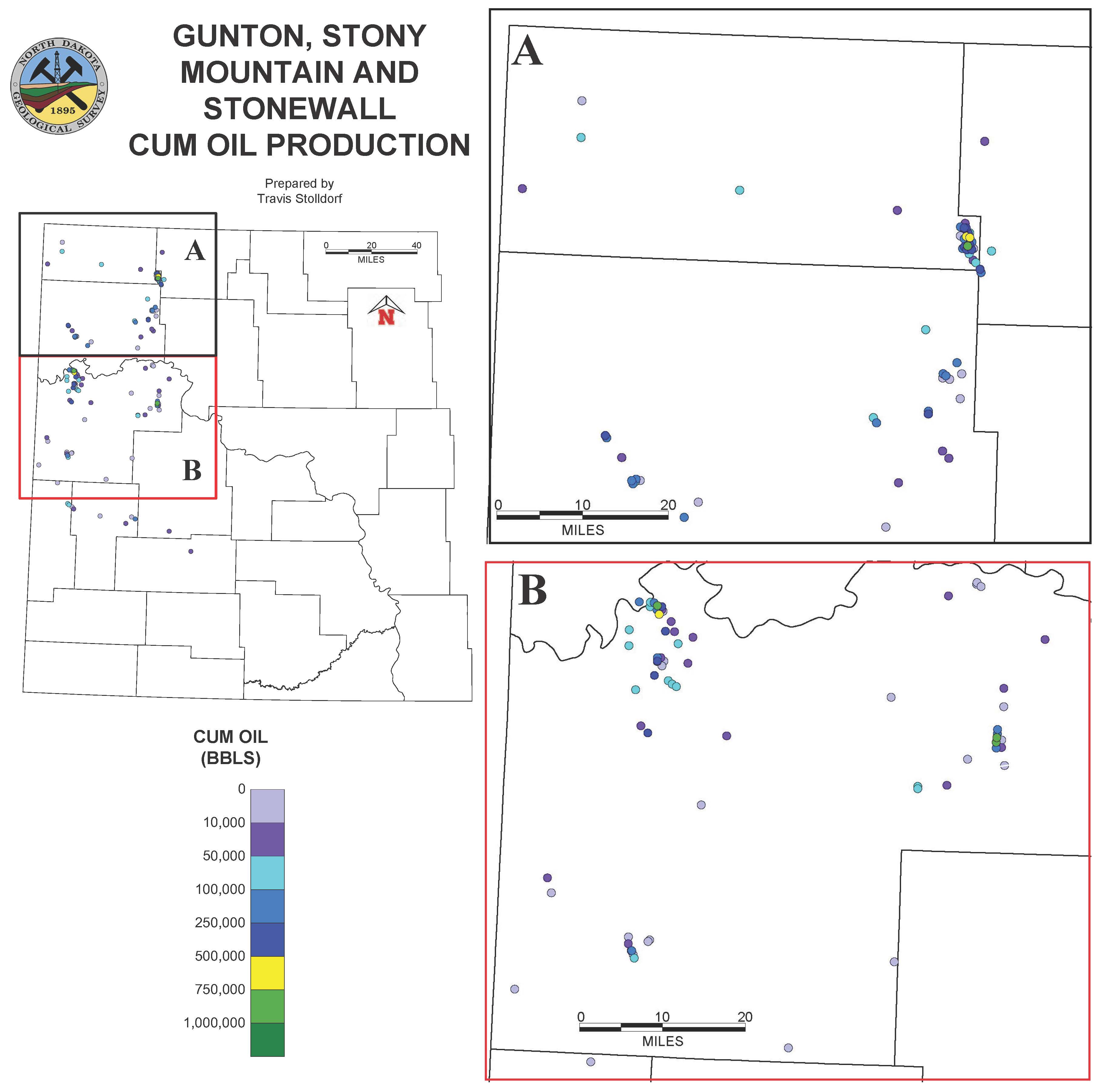
Stonewall, Stony Mountain and Gunton Production and Drill Stem Test (DST) Maps: Stolldorf, T.D., 2020 |
| GI-231 Summary DST Map Production Map Cum Prod Map Well List |
Red River Production and Drill Stem Test (DST) Maps: Stolldorf, T.D., 2020 |
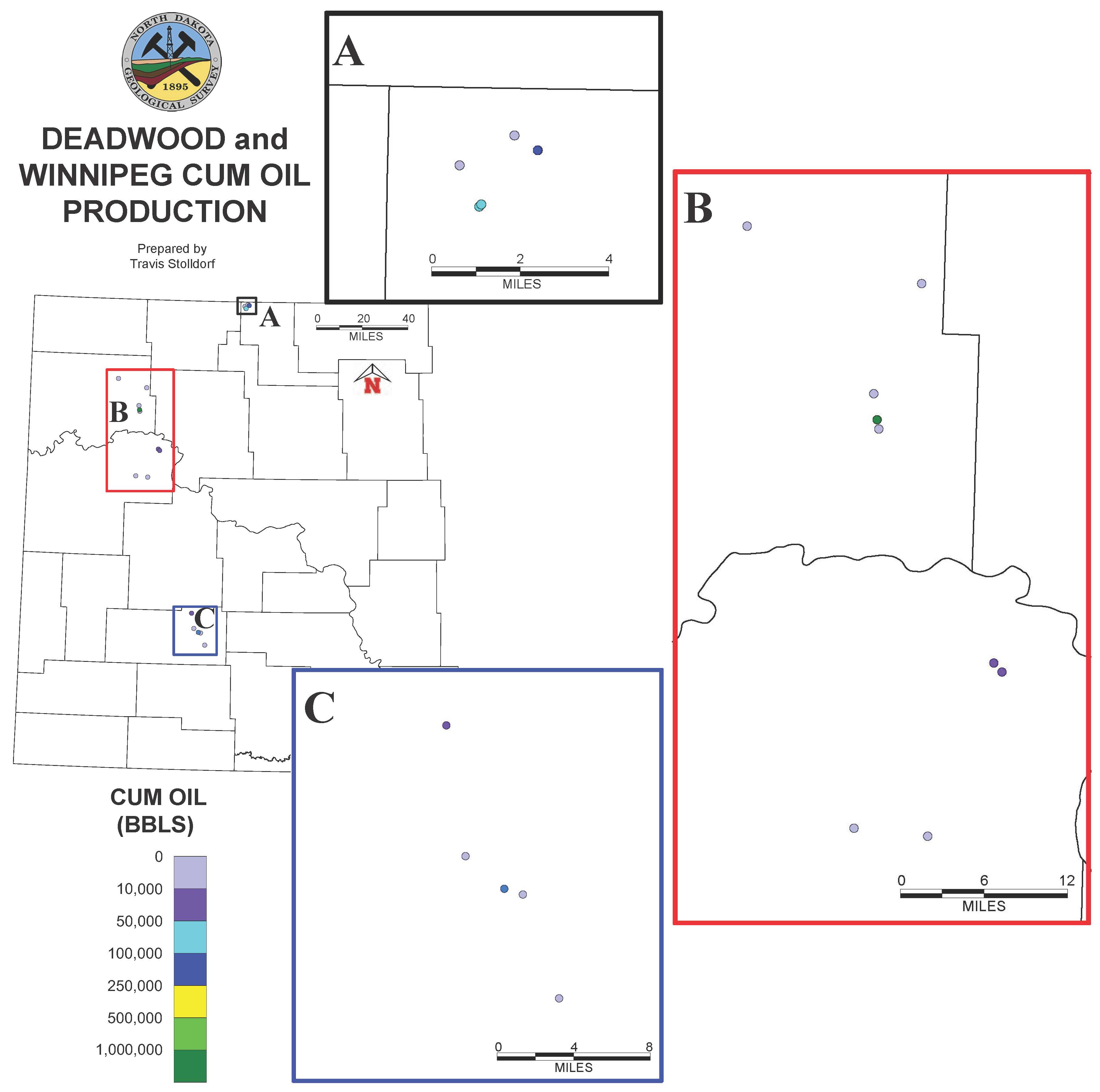
| GI-230 Summary DST Map Production Map Cum Prod Map Well List |
Deadwood and Winnipeg Production and Drill Stem Test (DST) Maps: Stolldorf, T.D., 2020 |
| GI-229 | Salt Isopach of the Devonian Prairie Formation, Parshall 100K Sheet, North Dakota: Kruger, N.W., 2020. Available online. |
| GI-228 | Salt Isopach of the Devonian Prairie Formation, Garrison 100K Sheet, North Dakota: Kruger, N.W., 2020. Available online. |
| GI-227 | Tectonic Map of the Western Dakotas Uplift and Surrounding Areas. Bader, J.W., 2020. Available online. |
| GI-226 | Birdbear Formation (Late Devonian) of North Dakota A Core Atlas: Bader, J.W., 2019. Available online. |
| GI-225 Plate 1 | Revisiting Stratigraphic Nomenclature for the Three Forks Formation in western North Dakota: Nesheim, T.O., Nwachukwu, F.C., and Nordeng, S.H., 2019. Available online. |
| GI-224 | Windblown Sand Resources in the Denbigh Quadrangle by Anderson, F.J., 2020. Available online. |
| GI-223 | Helium Trends in North Dakota: Nesheim, T.O. and Kruger, N.W., 2019. Available online. |
| GI-222 | Review of Production, Completions, and Future Potential of the lower Tyler Formation – Central Williston Basin, North Dakota: Nesheim, T.O., 2019. Available online. |
| GI-221 Plate 1 Plate 2 Plate 3 | Prairie Formation Salt Isopach and Depth Maps, North Dakota: Kruger, N.W., 2019. 3-map series. Available online. |
| GI-220 | Inyan Kara Sandstone Isopach Map, Minot 100K Sheet, North Dakota. Bader, J.W., and Stolldorf, T.D., 2019. Available as a traditional paper map ($10.00). |
| GI-219 | Salt Isopach of the Devonian Prairie Formation, Minot 100K Sheet, North Dakota: Kruger, N.W., 2019. Available online. |
| GI-218 | Sieve Analysis of Selected Late-Cretaceous and Tertiary (Paleocene) Bedrock Sandstones in North Dakota for Potential use as Proppant. Anderson, F.J., Moxness, L.D., Kruger, N.W., Murphy, E.C., and Maike, C.A., 2019. Available online. |
| GI-217 | Salt Isopach of the Devonian Prairie Formation, Stanley 100K Sheet, North Dakota: Kruger, N.W., 2019. Available online. |
| GI-216 | The Potential of the Hazen-Stanton Dunes for use as Natural Sand Proppant: Anderson F.J., 2019. Available online. |
| GI-215 White Lake Mountrail Patience Lake Belle Plaine White Bear Esterhazy | K2O Grades of the Potash-containing Members of the Prairie Formation, Kenmare 100K Sheet, North Dakota. Kruger, N.W., 2019. 6 map series. |
| GI-214 Plate 1 Plate 2 | Stratigraphic and Structural Relations of the Birdbear Formation (Devonian), Western North Dakota: Bader, J.W., 2018. Available online. |
| GI-213 Appendix - Core Data Appendix - Drill Stem Test Appendix - Perforation Interval & Production | Spatial distribution of elevated oil saturations within the Midale subinterval (Mississippian Madison Group), Burke County – North Dakota: Nesheim, T.O., 2018. Available online. |
| GI-212 | Inyan Kara Sandstone Isopach Map, Bottineau 100K Sheet, North Dakota. Bader, J.W., and Stolldorf, T.D., 2018. Available as a traditional paper map ($10.00). |
| GI-211 | Inyan Kara Sandstone Isopach Map, Mohall 100K Sheet, North Dakota. Bader, J.W., and Stolldorf, T.D., 2018. Available as a traditional paper map ($10.00). |
| GI-210 | Review of Hydrocarbon Production from the Stonewall and lower Interlake Formations: Western North Dakota - Williston Basin. Nesheim, T.O., 2018. Available online. |
| GI-209 White Lake Mountrail Patience Lake Belle Plaine White Bear Esterhazy |
K2O Grades of the Potash-containing Members of the Prairie Formation, Crosby 100K Sheet, North Dakota. Kruger, N.W., 2018. 6 map series. |
| GI-208 | 2018 Core Workshop, Bakken-Three Forks, Madison & Spearfish Formations, Bader, J. W., LeFever, J. A., Nesheim, T.O., and, Stolldorf, T.D., 2016. Available online. |
| GI-207 | Eolian Sands in North Dakota Evaluated for use as Natural Sand Proppant for Oil & Gas Wells. Anderson F.J., 2018. Available online. |
| GI-206 | Inyan Kara Sandstone Isopach Map, Kenmare 100K Sheet, North Dakota. Bader, J.W., Nesheim, T.O., and Stolldorf, T.D., 2018. Available as a traditional paper map ($10.00). |
| GI-205 | Examination of Oil Saturations and Horizontal Well Production for the Middle and Lower Three Forks Formation, Nesheim, T.O., 2018. Available online. Shape files available upon request. |
| GI-204 | Inyan Kara Sandstone Isopach Map, Killdeer 100K Sheet, North Dakota. Bader, J.W., Nesheim, T.O., and Stolldorf, T.D., 2017. Available as a traditional paper map ($10.00). |
| GI-203 | Inyan Kara Sandstone Isopach Map, Grassy Butte 100K Sheet, North Dakota. Bader, J.W., and Nesheim, T.O., 2017. Available as a traditional paper map ($10.00). |
| GI-202 | The subsurface storage potential in the Stutsman County area: Nesheim, T.O., 2017. Available in paper format ($10.00). |
| GI-201 | Inyan Kara Sandstone Isopach Map, Crosby 100K Sheet, North Dakota. Bader, J.W. and Nesheim, T.O., 2017. Available as a traditional paper map ($10.00). |
| GI-200 | Generalized Geologic Cross-sections of Eastern North Dakota: Nesheim, T.O., 2016. Available in paper format ($10.00). |
| GI-199 | Inyan Kara Sandstone Isopach Map, Stanley 100K Sheet, North Dakota. Bader, J.W., Nesheim, T.O., and Ternes, S.A., 2016. Available as a traditional paper map ($10.00). |
| GI-198 | Inyan Kara Sandstone Isopach Map, Williston 100K Sheet, North Dakota. Bader, J.W., Nesheim, T.O., and Ternes, S.A., 2016. Available as a traditional paper map ($10.00). |
| GI-197 | Geomorphology of Dune Sand Resources in Western Pierce County, North Dakota. Anderson, F.J., 2016. Available as traditional paper map ($10.00). |
| GI-196 | 2016 Core Workshop, Red River, Three Forks & Inyan Kara Formation, Nesheim, T.O., LeFever, J. A. and Bader, J. W, 2016. Available online. |
| GI-195 | GI-195 Lineament Mapping and Analysis in the North-Central Williston Basin in Northwestern North Dakota, by Anderson, Fred J., 2016. Available in traditional paper map format ($15.00 per poster). Shape files require GIS or other mapping related software to open. |
| GI-194 | Inyan Kara Sandstone Isopach Map, Parshall 100K Sheet, North Dakota. Bader, J.W., and Nesheim, T.O., 2016. Available as a traditional paper map ($10.00). |
| GI-193 Plate I Plate II Plate III |
Sequence Stratigraphy of the Inyan Kara Formation, Northwestern North Dakota: Extracting the Maximum from Minimal Core and Outcrop Data. Bader, J.W., 2016. Available as a 3-sheet traditional paper poster ($15.00). |
| GI-192 | Geology of Saltwater Disposal into the Dakota Group of Western North Dakota. Bader, J.W., 2016. |
| GI-191 | Hydrocarbon Generation Significance of Kukersites, the Prospective Petroleum Source Beds of the Red River Petroleum System – Williston Basin, North America. Nesheim, T.O., 2016. |
| GI-190 | Geomorphology of Dune Sand Resources in Southwestern Sargent County. Anderson, F.J., 2016. Available as a traditional paper map ($10.00). |
| GI-189 | Inyan Kara Sandstone Isopach Map, Watford City 100K Sheet, North Dakota. Bader, J.W., 2015. Available as a traditional paper map ($10.00). |
| GI-188 | RMAG Core Symposium: Upper and Middle Three Forks Formation, Williston Basin. Nordeng, S.H., LeFever, J.A., LeFever, R.D., and Hou, Xiaodong, 2015. Available as a traditional paper map ($10.00). |
| GI-187 | Earthquakes in North Dakota. Anderson, F.J., 2015. Available as a traditional paper map ($10.00). |
| GI-186 | Stratigraphic Correlation and Geochemical Analysis of Kukersite (Source Rock) Beds within the Ordovician Red River Formation, Southwestern North Dakota. Nesheim, T.O., Nordeng, S.H., and Bader, J.W., 2015. Available in paper map format ($10.00). |
| GI-185 | Isopach on the Inyan Kara: Julie LeFever, 2015. Available in paper map format ($10.00). |
| GI-184 | Uranium in North Dakota. Murphy, E.C., 2015. |
| GI-183 | Geochemical Characterization of Natural Gas Occurrences in Selected Ground-Water Wells in North Dakota. Anderson, F.J., 2015. Available in traditional map format ($10.00). Shape files require GIS or other mapping related software to open. |
| GI-182 | First 90 Day Average Spearfish Horizontal Production by Well Available in paper map format ($20) or download online. ($5) for Shape files which require GIS or other mapping related software to open. |
| GI-181 Plate I Plate II |
Preliminary Examination of Source Beds within the Stonewall Formation (Ordovician-Silurian), Western North Dakota, Nesheim, T.O., 2014. Available in traditional paper format ($10.00). Shape files require GIS or other mapping related software to open. |
| GI-180 Appendix |
Beaver Creek Anticline, West-Central North Dakota. Nesheim, T.O., 2014. North Dakota Geological Survey, Geologic Investigations No. 180. Available in traditional paper map format ($10.00). Shape files require GIS or other mapping related software to open. |
| GI-179 | Stratigraphic Core Atlas. LeFever, J.A., 2014. |
| GI-178 | Activation Energies and RockEval Analyses of Kerogenites in the Red River Formation in North Dakota. Nordeng, S.A., 2014. Available online. |
| GI-177 | Continued Geological and Geochemical Evaluation of the Tyler Formation: a Dual Petroleum System. Nesheim, T. O., and Nordeng, S. H., 2014. |
| 2014 Core Workshop: Tyler, Pronghorn Member-Bakken & Red River Formations. LeFever, J. A., Nordeng S. H. and Nesheim T. O., 2014. Available online or in paper booklet for $10 | |
| GI-175 | Reserve Pit and Brine Pond Studies in North Dakota. Murphy, E. C., 2014. 1985 Brine Pond Study |
| GI-174 | Bakken Sweetspots, Production Statistics, Bounding Pronghorn Facies and Magnetic Anolmalies. Nordeng, S.H. and LeFever J. A., 2014. Available in paper poster format $15. |
| GI-173 | Core Based Examination of Upper Tyler Formation Source Rocks within Southwestern North Dakota. Nesheim, T.O., & Nordeng, S.H., 2014. |
| GI-172 | The Compensation Effect from Simulated Programmed Pyrolysis Experiments: A Way to Standardize Source Rock Kinetic Parameters. Nordeng, S. H., 2013 Available online. |
| GI-171 | Part 1, Part 2, Part 3 Reservoirs of the Bakken Petroleum System: A Core-based Perspective. LeFever, Julie; LeFever, Richard & Nordeng, Stephan, 2013. Available in traditional paper map format for ($15.00 per poster). |
| GI-170 | Geotechnical Insights of the Bakken. LeFever, J. A., 2013. Available online |
| GI-169 | Examination of the Icebox Formation’s (Winnipeg Group, Ordovician) Source Rock Potential within North Dakota. Nesheim, T.O. & Nordeng, S.H., 2013. Shape files require GIS or other mapping related software to open. |
| GI-168 | Bakken - Three Forks Percentile Ranked Production (60-90 Days). Nordeng, S. H., 2013. Available in traditional paper map format ($10.00). Shape files require GIS or other mapping related software to open. |
| GI-167 |
Production and Hydrocarbon Shows from the Black Island Formation, Winnipeg Group (Ordovician). Nesheim, T.O. & Nordeng, S.H., 2013. Available in traditional paper map format ($10.00). Shape files require GIS or other mapping related software to open. |
| GI-166 (Plate 1) | Examination of Hydrocarbon Saturation within the upper Black Island Formation (Garland Member), Winnipeg Group, Nesheim, T.O., 2013. Available in traditional paper format ($10.00). Shape files require GIS or other mapping related software to open. |
| GI-165 | Role of Nomenclature in Pay Zone Definitions, Bakken - Three Forks Formations, ND. LeFever, Julie; LeFever, Richard & Nordeng, Stephan, 2013. Available in traditional paper map format ($25.00). |
| GI-164 | Evaluating Source Rock Maturity Using Multi-Sample Kinetic Parameters from the Bakken Formation (Miss.–Dev.), Williston Basin, ND. Nordeng, Stephan 2013. |
| GI-163 | Determination of Activation Energy and Frequency Factor for Samples of the Bakken Formation (Miss.-Dev.) Williston Basin ND: Nordeng, S.H., 2012. |
| GI-162 | Three Dimensional Geologic Model of Subsurface Salt Intervals within the Williston Basin, Northwestern North Dakota: by Nesheim, Timothy. O. & LeFever, Julie A., 2012. |
| GI-161( Poster Format or Document Format) | Review of Ordovician Black Island Formation (Winnipeg Group) Oil and Gas Production : by Nesheim, Timothy. O., 2012. Available in traditional paper map format ($10.00). |
| GI-160 | Review of Radiometric Ages from North Dakota's Precambrian Basement: Nesheim, T.O., 2012. Available $10.00 for traditional paper map format. |
| GI-159 | Depth to the Harmon Bed, Murphy, E.C., 2012. Available $20.00 for traditional paper format. |
| GI-158 | Alumina Content of the Bear Den Member & the Rhame Bed in ND. Murphy, Edward, 2012. Available in traditional paper map format ($10.00). shape files require GIS or other mapping related software to open. |
| GI-157 | Petroleum Geology of the Tyler Formation (Pennsylvanian), North Dakota. Nesheim, T.O. and Nordeng, S.H., 2012. Available online only. |
| GI-156 | Preliminary Report on the Bakken Formation, North-Central ND. LeFever, Julie & Nordeng, Stephan; 2012. Available in poster format $25. |
| GI-155 | 2012 Core Workshop Booklet, LeFever, Julie; Nordeng, Stephan; Nesheim, Timothy. Available in paper booklet for $20. |
| GI-154 | Lineament Density & Generalized Well Production in the Minot area 250K Sheet, ND. Anderson, F.J., 2012. Available in paper map format $25 . Shape files require GIS or other mapping related software to open. |
| GI-153 | Analysis of Lineaments and Horizontal Wells in the Parshall Area, North Dakota, Anderson, F.J., 2012 . Available in paper map format ($10.00). |
| GI-152 | Generalized Geologic Cross-Section in Southeastern North Dakota: by Anderson, F.J., 2012. Geologic cross-section created from available well data in support of energy industry inquiries related to Compressed Air Energy Storage (CAES) possibilities. Available online only. |
| GI-151 | Source Rock Intervals within the Tyler Formation, ND, Nesheim, T. O. & Nordeng, S. H., 2012. Available in paper map format ($25). |
| GI-150 | Spearfish Formation - Another Unconventional Target, LeFever, J. A. & LeFever, R. D., 2012. Available in paper map format ($25). |
|
GI-149
Shapefile |
First 60 - 90 Day Average Bakken Horizontal Production by Well Available in paper map format ($20) or download online. Shape files which require GIS or other mapping related software to open. |
| GI-148 | A Preliminary Evaluation of the Resource Potential of the Tyler Formation (Penn.) Based on a Combination of a Kinetically Based Maturation Index, Organic Carbon Content & Interval Thickness, Nordeng, S.H. and Nesheim, T.O., 2012. Available in paper map format ($25). |
| GI-147 | Lineament Density and Generalized Well Production in the Dickinson area, ND, 250K Sheet, Anderson, F. J., 2011. Available in paper map format ($15) shape files require GIS or other mapping related software to open. |
| GI-146 | Determination of Subsurface Temperatures and the Fraction of Kerogen Converted to Petroleum within the Rauch Shapiro Fee #21-9, Billings Co., ND. Nordeng, S.H. and Nesheim, T.O., 2011. Available in paper map format ($15). |
| GI-145 | Lineament Mapping and Analysis in the Northeastern Williston Basin in North-Central North Dakota, by Anderson, Fred J., 2012. Available in traditional paper map format ($15.00 per poster). Shape files require GIS or other mapping related software to open. |
| GI-144 | Correlation of Fluid Overpressure and Hydrocarbon Presence in the Tyler Formation, North Dakota by Nesheim, Timothy O. and Nordeng, Stephan H., 2011. Available in paper poster format ($10). |
| GI-143 | Niobrara Formation Cores in North Dakota: by Anderson, F.J., 2011 . Available in traditional paper map poster format (68"x46") for ($25.00). |
| GI-142 | Depth to Bedrock in the Fargo Area, North Dakota: by Anderson, F.J., 2011. 1:48,000 scale map depicting the depth and type of shallow bedrock found in the greater Fargo area. Available in traditional paper map format ($10.00). Shape files require GIS or other mapping related software to open. |
| GI-141 | Three Dimensional Geologic Model of Southwestern North Dakota: by Nesheim, T. O., 2011. |
| GI-140 | Sandy Lithofacies within the Icebox Formation (Ordovician), North Dakota & Montana: by LeFever, R. D. and LeFever, J. A. 2011. Available in paper map format ($20.00). |
| GI-139 | Uranium concentrations in groundwater southwestern North Dakota: by Murphy, E. C., 2011. 1:250,000 scale poster, available in paper map format ($15.00). shape files require GIS or other mapping related software to open. |
| GI-138 | Spikes on gamma ray logs southwestern North Dakota: by Murphy, E. C., 2011. 1:250,000 scale poster, available in paper map format ($15.00). shape files require GIS or other mapping related software to open. |
| GI-137 | Three Dimensional Geologic Model of Northwestern North Dakota: by Nesheim, Timothy. O. & Nordeng, Stephan. H., 2011. |
| GI-136 | Cyclical Sedimentation Patterns of the Bakken Formation, North Dakota: by LeFever,Julie, A.; LeFever, Richard D. and Nordeng, Stephan H.,2011. Available in traditional paper map format ($15.00). |
| GI-135 | Geochemical Indicators of Shallow Gas in Groundwater in North Dakota, Anderson, F.J., 2011. 1:1,000,000 scale map of the distribution of shallow gas ground-water geochemical indicators compared with the locations and results of previously completed shallow gas field screening in water wells across the state, supplemented with a brief discussion of the relationship between interpreted ground-water geochemistry and historic and recent shallow gas occurrences found in wells across North Dakota. Available in traditional paper map format ($10.00). shape files require GIS or other mapping related software to open. |
| GI-134 | Information on the Spearfish Formation: by LeFever, Julie A., 2011. Available in paper format for ($10.00). |
| GI-133 | An Example of Tyler Formation Core by Nesheim, Timothy O. and Nordeng, Stephan H., 2011. Available in traditional paper map format ($10.00). |
| GI-132 | North to South Cross-Section of the Tyler Formation (Pennsylvanian) with RockEval Data, North Dakota by Nesheim, Timothy O. and Nordeng, Stephan H., 2011. Available in traditional paper map format ($10.00). |
| GI-131 | Shallow Gas Field Screening in North Dakota: Field Data Report (2009 & 2010) for Selected Counties: by Anderson, F.J., Gudmunsen, C.B., Hall, B.N., Ries, A.J., Christensen, A.R., Bubach, B.J., 2010. |
| GI-130 | Locations of Sand and Gravel Sites in North Dakota, Anderson, F.J., 2010. 1:500,000 scale map compilation of the distribution and locations of previously mapped sand and gravel resources, supplemented with the locations of historic and inactive sand and gravel extraction sites and locations of recent NDGS sand and gravel sampling conducted in support of ongoing proppant and industrial sand resource investigations in North Dakota. Available in traditional paper map format ($15.00). |
| GI-129 | Lineament Mapping and Analysis in the Southern Williston Basin in Southwestern North Dakota, by Anderson, Fred A., 2011 . Available in paper map format ($15.00), shape files require GIS software to open. |
| GI-128 | Locations of FID Shallow Gas Occurrences in North Dakota: by Anderson, F.J., Gudmunsen, C.B., Hall, B.N., Ries, A.J., Christensen, A.R., and Bubach, B.J., 2010. Available in traditional paper map format ($25.00). |
| GI-127 | Resource Potential of the Tyler Formation: by Nordeng, Stephan H. and Nesheim, Timothy O., 2010. Available in traditional paper map format ($10.00). |
| GI-126 | Field Screening for Shallow Gas in Dickey County, North Dakota: by Anderson, F.J., and Bubach, B.J., 2010. Available in paper map format ($10.00). |
| GI-125 | Field Screening for Shallow Gas in Pembina County, North Dakota: by Anderson, F.J., and Bubach, B.J., 2010. Available in paper map format ($10.00). |
| GI-124 | Field Screening for Shallow Gas in Walsh County, North Dakota: by Anderson, F.J., and Bubach, B.J., 2010. Available in paper map format ($10.00). |
| GI-123 | First 60 - 90 Day Average Bakken Pool Production by Well: by Stephan H. Nordeng, 2010. Available in traditional paper map format ($10.00). |
| GI-122 | Field Screening for Shallow Gas in Grand Forks County, North Dakota: by Anderson, F.J., and Bubach, B.J., 2010. Available in paper map format ($10.00). |
| GI-121 | Field Screening for Shallow Gas in Cavalier County, North Dakota: by Anderson, F.J., and Gudmunsen, C.B., 2010. Available in paper map format ($10.00). |
| GI-120 | Field Screening for Shallow Gas in Ramsey County, North Dakota: by Anderson, F.J., and Gudmunsen, C.B., 2010. Available in paper map format ($10.00). |
| GI-119 | Field Screening for Shallow Gas in Nelson County, North Dakota: by Anderson, F.J., and Gudmunsen, C.B., 2010. Available in paper map format ($10.00). |
| GI-118 | Field Screening for Shallow Gas in Foster County, North Dakota: by Anderson, F.J., and Gudmunsen, C.B., 2010. Available in paper map format ($10.00). |
| GI-117 | Field Screening for Shallow Gas in Eddy County, North Dakota: by Anderson, F.J., and Gudmunsen, C.B., 2010. Available in paper map format ($10.00). |
| GI-116 | Evidence for Potential CH4 Sourcing and Methanogenesis in Late Cretaceous Shales along the Eastern Flank of the Williston Basin in North Dakota: by Fred J. Anderson, 2010. Poster. Available in traditional paper poster format ($25.00). |
| GI-115 | Field Screening for Shallow Gas in Williams County, North Dakota: by Anderson, F.J., and Gudmunsen, C.B., 2010. Available in paper map format ($10.00). |
| GI-114 | The National Geochemical Survey, A Summary of ND Datasets: by Manz, L.A., Hopkins, D. G., and Ulmer, M. G., 2010. |
| GI-113 | Field Screening for Shallow Gas in McKenzie County, North Dakota: by Anderson, F.J., and Gudmunsen, C.B., Available in paper map format ($10.00). |
| GI-112 | 2010 Bakken Three Forks Core Workshop: LeFever, Julie A.; LeFever, Richard D. and Nordeng, Stephan H., 2010. Available on paper booklet for ($35.00). |
| GI-111 | Field Screening for Shallow Gas in Wells County, North Dakota: by Anderson, F.J., Christensen, A.R., and Ries, A.J., 2010. Available in paper map format ($10.00). |
| GI-110 | Field Screening for Shallow Gas in Cass County, North Dakota: by Anderson, F.J., and Hall, B.N., 2010. Available in paper map format ($10.00). |
| GI-109 | Field Screening for Shallow Gas in McIntosh County, North Dakota: by Anderson, F.J., and Ries, A.J., 2010. Available in paper map format ($10.00). |
| GI-108 | Field Screening for Shallow Gas in Divide County, North Dakota: by Anderson, F.J., and Christensen, A.R., 2010. Available in paper map format ($10.00). |
| GI-107 | Field Screening for Shallow Gas in Sargent County, North Dakota: by Anderson, F.J., and Hall, B.N., 2010. Available in paper map format ($10.00). |
| GI-106 | Field Screening for Shallow Gas in Hettinger County, North Dakota: by Anderson, F.J., and Ries, A.J., 2010. Available in paper map format ($10.00). |
| GI-105 | Field Screening for Shallow Gas in Grant County, North Dakota: by Anderson, F.J., and Ries, A.J., 2010. Available in paper map format ($10.00). |
| GI-104 | Field Screening for Shallow Gas in Burke County, North Dakota: by Anderson, F.J., and Christensen, A.R., 2010. Available in paper map format ($10.00). |
| GI-103 | Field Screening for Shallow Gas in Mountrail County, North Dakota: by Anderson, F.J., and Christensen, A.R., 2010. Available in paper map format ($10.00). |
| GI-102 | Field Screening for Shallow Gas in Adams County, North Dakota: by Anderson, F.J., and Ries, A.J., 2010. Available in paper map format ($10.00). |
| GI-101 | Field Screening for Shallow Gas in Bowman County, North Dakota: by Anderson, F.J., and Ries, A.J., 2010. Available in paper map format ($10.00). |
| GI-100 | Field Screening for Shallow Gas in McLean County, North Dakota: by Anderson, F.J., and Christensen, A.R., 2010. Available in paper map format ($10.00). |
| GI-99 | Field Screening for Shallow Gas in Golden Valley County, North Dakota: by Anderson, F.J., and Gudmunsen, C.B., 2010. Available in paper map format ($10.00). |
| GI-98 | Field Screening for Shallow Gas in Richland County, North Dakota: by Anderson, F.J., and Hall, B.N., 2010. Available in paper map format ($10.00). |
| GI-97 | Field Screening for Shallow Gas in Slope County, North Dakota: by Anderson, F.J., and Ries, A.J., 2010. Available in paper map format ($10.00). |
| GI-96 | Field Screening for Shallow Gas in Billings County, North Dakota: by Anderson, F.J., and Gudmunsen, C.B., 2010. Available in paper map format ($10.00). |
| GI-95 | Field Screening for Shallow Gas in Dunn County, North Dakota: by Anderson, F.J., and Gudmunsen, C.B., 2010. Available in paper map format ($10.00). |
| GI-94 | Earthquakes in North Dakota: Compiled by: Anderson, Fred J., 2010, 1:750,000 scale map. Price $10.00. |
| GI-93 | Sheet 1: Structural Transect of the Sanish and Parshall Fields, Bakken Formation, Mountrail County, North Dakota - Julie A. LeFever and Stephan H. Nordeng. Sheet 2: Stratigraphic Transect of the Sanish and Parshall Fields, Bakken Formation, Mountrail County, North Dakota - Julie A. LeFever and Stephan H. Nordeng Available in paper format ($10.00) per map. |
| GI-92 | Shallow Gas Geochemical Exploration Indicators in Ground-Water Wells in North Dakota: by Anderson, F.J., 2010. Available in paper map format ($20.00). |
| GI-91 | Field Screening for Shallow Gas in Ransom County, North Dakota: by Anderson, F.J., and Hall, B.N., 2010. Available in paper map format ($10.00). |
| GI-90 | Field Screening for Shallow Gas in Stark County, North Dakota: by Anderson, F.J., and Ries, A.J., 2009. Available in paper map format ($10.00). |
| GI-89 | Field Screening for Shallow Gas in Oliver County, North Dakota: by Anderson, F.J., and Gudmunsen, C.B., 2009. Available in paper map format ($10.00). |
| GI-88 | Field Screening for Shallow Gas in Traill County, North Dakota: by Anderson, F.J., and Hall, B.N., 2009. Available in paper map format ($10.00). |
| GI-87 | Methane Occurrence in Glacial Buried-Valley Aquifer Systems in North Dakota, by Fred J. Anderson, 2009. |
| GI-86 | Exploration for Shallow Natural Gas in North Dakota by FID Field Screening of Ground-Water Wells, by Fred J. Anderson, Brian, N. Hall, Cassie B. Gudmunsen, Adam J. Ries, and Allison R. Christensen, 2009. Poster. Available in poster format ($25.00). |
| GI-85 | Depth to Precambrian Basement Rock in North Dakota: by Anderson, F.J., 2009, 1:750,000 scale map. Available in paper map format ($10.00). |
| GI-84 | Field Screening for Shallow Gas in Mercer County, North Dakota: by Anderson, F.J., and Gudmunsen, C.B., 2009. Available in paper map format ($10.00). |
| GI-83 | Potential Shallow Gas Sands & Gravels - Griggs & Steele Counties, North Dakota: by Anderson, F.J., 2009, Available in paper map format ($10.00). |
| GI-82 | Field Screening for Shallow Gas in Griggs County, North Dakota: by Anderson, F.J., and Hall, B.H., 2009, Available in paper map format ($10.00). |
| GI-81 | A 3D geologic model of the Parshall area, North Dakota: by Helms, L.D., Nordeng, S.H., LeFever, J.A., Anderson, F.J., 2009. |
| GI-80 | Lineament mapping and analysis in the northeastern Williston Basin: exploration and production trends in the Parshall area, North Dakota: by Anderson, F.J., 2009. |
| GI-79 | Organic geochemical patterns in the Bakken Source System: by Nordeng, S.H. And LeFever, J.A., 2009. Available in paper map format ($15.00). |
| GI-78 | Salts as candidates for air storage in the Williston Basin: by Nordeng, S.H., 2009. |
| GI-77 | Lineament Density and Generalized Well Production in the Parshall Area, North Dakota, Anderson, F.J., 2009. Available in paper map format ($10.00), shape files require GIS software to open. |
| GI-76 | The Three Forks Formation - North Dakota to Sinclair Field, Manitoba: Julie A. LeFever and Stephan H. Nordeng, 2009. $15.00 paper poster. |
| GI-75 | Three Forks Formation Log to Core Correlation: by Stephan H. Nordeng and Julie A. LeFever, 2009. Available in paper format ($15.00 ). |
| GI-74 | Shallow Gas Field Screening in North Dakota: Field Data Report for Selected Counties: by Anderson, F.J., 2009. |
| GI-73 | Locations of FID Shallow Gas Occurrences in Selected Counties in North Dakota: by Anderson, F. J., 2008. 1:50,000 scale, available in paper map format ($15.00). |
| GI-72 | Shallow Gas Exploration and Production in North Dakota: by Anderson, F.J., 2008. PowerPoint presentation given at the 2008 Rocky Mountain Unconventional Gas Conference in Rapid City, SD. Available on-line only. |
| GI-71 | Field Screening for Shallow Gas in North Dakota: by Anderson, F.J., 2008. Available in paper format ($25.00). |
| GI-70 | Lineament Mapping and Analysis in the Northeastern Williston Basin of North Dakota, Anderson, F.J., 2008. Available in paper map format ($15.00 per poster-6 total posters). Shape files require GIS software to open. |
| GI-69 | Deep Geothermal Resources: Estimated Temperature on Top of the Lodgepole Formation Cedar Hills field, Bowman and Slope Counties, ND, Manz, Lorraine A., 2008. Available in paper map format ($15.00), shape files require GIS software to open. |
| GI-68 | Field Screening for Shallow Gas in Benson County, North Dakota: by Anderson, F.J., 2008, Available in paper map format ($10.00). |
| GI-67 | Field Screening for Shallow Gas in Logan County, North Dakota: by Anderson, F.J., 2008, Available in paper map format ($10.00). |
| GI-66 | Field Screening for Shallow Gas in Sheridan County, North Dakota: by Anderson, F.J., 2008, Available in paper map format ($10.00). |
| GI-65 | Correlation Cross Section – Three Forks Formation: LeFever, Julie A. and Nordeng, Stephan H., 2008, Available in paper format for ($15.00). |
| GI-64 | Isopach of the Three Forks Formation: LeFever, Julie A., 2008. Available in paper format ($10.00). |
| GI-63 | Rock-Eval Data of the Bakken Formation: LeFever, Julie A., 2008, 6 map series. Available in paper format ($10.00) per map shape files require GIS software to open. Page 1, Page 2, Page 3, Page 4, Page 5, Page 6 |
| GI-62 | The Bakken Revisited 2008 Bakken Core Workshop: LeFever, Julie A. and Nordeng, Stephan H., 2008. |
| GI-61 | Time-Temperature Index of the Bakken Formation in North Dakota: Nordeng, Stephan H., 2008. Available in paper format ($10.00). |
| GI-60 | Field Screening for Shallow Gas in Selected Wells in Burleigh County, North Dakota: by Anderson, F.J., 2008. Available in paper map format ($10.00). |
| GI-59 | Structural Contour and Isopach Maps of the Bakken Formation in North Dakota: by LeFever, Julie A., 2008, 5 map series. Available in paper format ($10.00) per map. Sheet 1, Sheet 2, Sheet 3, Sheet 4, Sheet 5 |
| GI-58 | Historical Shallow Natural Gas Occurrences in Cretaceous and Tertiary Aquifer in West-Central North Dakota: by Anderson, F.J., 2008, online only. |
| GI-57 | Field Screening for Shallow Gas in Pierce County, North Dakota: by Anderson, F.J., 2007, Available in paper map format ($10.00). |
| GI-56 | Field Screening for Shallow Gas in LaMoure County, North Dakota: by Anderson, F.J., 2007, Available in paper map format ($10.00). |
| GI-55 | Field Screening for Shallow Gas in Morton County, North Dakota: by Anderson, F.J., 2007, Available in paper map format ($10.00). |
| GI-54 | Field Screening for Shallow Gas in Barnes County, North Dakota: by Anderson, F.J., 2007, Available in paper map format ($10.00). |
| GI-53 | Field Screening for Shallow Gas in Kidder County, North Dakota: by Anderson, F.J., 2007, Available in paper map format ($10.00). |
| GI-52 | Field Screening for Shallow Gas in McHenry County, North Dakota: by Anderson, F.J., 2007, Available in paper map format ($10.00)). |
| GI-51 | Field Screening for Shallow Gas in Ward County, North Dakota: by Anderson, F.J., 2007, Available in paper map format ($10.00). |
| GI-50 | Field Screening for Shallow Gas in Burleigh County, North Dakota: by Anderson, F.J., 2007, Available in paper map format ($10.00). |
| GI-49 | Exploration frontiers in the Bakken Formation, Montana and North Dakota: LeFever, Julie A., 2007. Powerpoint presentation available online only. |
| GI-48 | Stratigraphic cross-section of Ratcliffe Interval through the Foreman Butte Field using neutron-density logs with the distribution of moveable hydrocarbons and water saturation: Nordeng, Stephan, H., 2007. |
| GI-47 | Preliminary Isopach Map on the Cretaceous Mowry – Inyan Kara Formation Interval in North Dakota: Anderson, Fred J. and Juenker, Bruce, J., 2007. Available in paper map format. Price ($10.00). |
| GI-46 | Geology of the Minot area: Anderson, Fred J. and Manz, Lorraine, A., 2007, Price $5.00. |
| GI-45 | Bakken Middle Member lithofacies 3: LeFever, Julie A., 2007, 6 maps in series. Available in paper map format ($10.00). Sheet 1, Sheet 2, Sheet 3, Sheet 4, Sheet 5, Sheet 6 |
| GI-44 | Preliminary Isopach Map on the Cretaceous Greenhorn-Mowry Formation Interval in North Dakota: Anderson, Fred J. and Juenker, Bruce, J., 2007. Available in paper map format ($10.00). |
| GI-43 | Precambrian Basement Drillhole Map of North Dakota: Anderson, Fred J., 2007,Price $10.00. |
| GI-42 | Field Screening for Shallow Gas in North Dakota: by Anderson, F.J., 2007. PowerPoint presentation given at the 2007 Geological Society of America Joint North Central/South Central Section Meeting in Lawrence, Kansas. Slides available on-line. |
| GI-41 | Stratigraphic and Structural Framework of Recent Ratcliffe (Mississippian, Charles Fm) Production in Western North Dakota: Nordeng, Stephan H., 2007. Available in paper map format ($10.00). |
| GI-40 | Uranium Deposits in Southwestern North Dakota: Murphy, Edward C., 2007, Price $5.00. |
| GI-39 | Landslide Inventory Map and Surficial Geology of the Valley City Area, North Dakota: North Dakota Geological Survey Anderson, Fred J., 2007, Price $10.00. |
| GI-38 | Preliminary Structure Contour Map on the Cretaceous Inyan Kara Formation in North Dakota: by Anderson, F.J., and Juenker, B.J., 2006. Available in paper map format ($10.00). |
| GI-37 | Preliminary Structure Contour Map on Top of the Cretaceous Mowry Formation in North Dakota: by Anderson, F.J., and Juenker, B.J., 2006. Available in paper map format ($10.00). |
| GI-36 | Field Screening for Shallow Gas in Towner County, North Dakota: by Anderson, F.J., 2006, Available in paper map format ($10.00). |
| GI-35 | Field Screening for Shallow Gas in Rolette County, North Dakota: by Anderson, F.J., 2006, Available in paper map format ($10.00). |
| GI-34 | Field Screening for Shallow Gas in Stutsman County, North Dakota: by Anderson, F.J., 2006, Available in paper map format ($10.00). |
| GI-33 | History, Geology, and Potential Hydrogeochemical Indicators of Natural Gas Occurrence and Production from Quaternary Glacial Drift and Upper-Cretaceous Sedimentary Bedrock in North-Central North Dakota, North Dakota: by Anderson, F.J., Shurr, G.W, and Fischer, D.W., 2006. PowerPoint presentation. Available on-line only. |
| GI-32 | Assessment of the Shallow Natural Gas Resource Potential of North Dakota: by Anderson, F.J., 2006. PowerPoint presentation. Available on-line only. |
| GI-31 | Preliminary Structure Contour Map on the Cretaceous Greenhorn Formation in North Dakota 2007, 1:1,000,000 scale map. Anderson, F. J. & Juenker, B. Available in paper map format ($10.00). |
| GI-30 | Shallow Gas Field Screening in Southeastern Steele County, North Dakota: by Anderson, F.J., 2006, Available in paper map format ($10.00). |
| GI-29 | Shallow Gas Field Screening in Emmons County, North Dakota: by Anderson, F.J., 2006, Available in paper map format ($10.00). |
| GI-28 | Historical Shallow Natural Gas Occurrences in Wells in Bottineau County, North Dakota: by Anderson, F.J., 2006, Available in poster format ($10.00). |
| GI-27 | Ice-walled lake plains in North Dakota by Manz, L.A., 2006, poster. Price $15.00. |
| GI-26 | Assessment of potential natural gas resources in North Dakota by Anderson, F.J., 2006, poster. Price $10.00. |
| GI-25 | Shallow gas occurrences in Quaternary deposits in North Dakota by Anderson, F.J., Murphy, E.C., Bluemle, J.P., and Fischer, D.W., 2006, poster. Price $20.00 |
| GI-24 | Quaternary geology of the Missouri River Valley and adjacent areas in northwest-central North Dakota: North Dakota by Manz, L.A., editor, 2006. |
| GI-23 | Geology of the Devils Lake Area, by Lorraine A Manz, 2005. This 23" x 35" poster features a 1:48,000-scale geologic map draped over a shaded relief background. Also included are photographs and descriptions of geologic features and geologic hazards. $5.00. |
| GI-22E | Cement Rock Mineral Resources of the Shawnee-McCanna Area, North Dakota, by Fred J. Anderson, 2005. Geologic Cross Sections. $3.00 |
| GI-22D | Cement Rock Mineral Resources of the Shawnee-McCanna Area, North Dakota, by Fred J. Anderson, 2005. Available Core Summary. Poster sized sheet with lithologic, paleontologic and geochemical data displayed from Niobrara Formation. This publication is available as an individual item or as a collection (GI-22A-E) of traditional paper map products or as digital GIS data files. $15.00. |
| GI-22C | Cement Rock Mineral Resources of the Shawnee-McCanna Area, North Dakota, by Fred J. Anderson, 2005. Mineral Extraction and Planning Map, 1:24,000. $5.00. |
| GI-22B | Cement Rock Mineral Resources of the Shawnee-McCanna Area, North Dakota, by Fred J. Anderson, 2005. Bedrock Geologic Map, 1:24,000. $5.00. |
| GI-22A | Cement Rock Mineral Resources of the Shawnee-McCanna Area, North Dakota, by Fred J. Anderson, 2005. Surficial Geologic Map, 1:24,000. $5.00. |
| GI-21 | Evaluation of Oil Reservoir Characteristics to Assess ND Carbon Dioxide Miscible Flooding Potential, by Ralph Nelms and Randolph B. Burke, 2004. PowerPoint presentation. Available on-line only. |
| GI-20 | The Upper Birdbear (Nisku) of Western North Dakota: Another Emerging Williston Basin Horizontal Play, by Tom Sperr and Randolph B. Burke, 2005. PowerPoint presentation. Available on-line only. |
| GI-19 | Overview of Bakken Stratigraphy and "Mini-Core" Workshop, by Julie A. LeFever, 2005. PowerPoint presentation. Available on-line only. |
| GI-18 | Horizontal Drilling Potential of the Middle Member Bakken Formation, North Dakota, by Julie A. LeFever, 2005. Powerpoint presentation. Available on-line only. |
| GI-17 | Overview of Bakken Stratigraphy in North Dakota and "Mini" Core Workshop, by Julie A. LeFever, 2005. Available on-line only. |
| GI-16 | Middle Bakken Play - Technical Problems and Questions - Possible Solutions, by Lynn D. Helms and Julie A. LeFever, 2005. PowerPoint presentation. Available on-line only. |
| GI-15 | Hydrocarbon Potential of the Bakken Formation, North Dakota, by Julie A. LeFever, 2005. PowerPoint presentation. Available on-line only. |
| GI-14 | Williston Basin Correlation - Bakken Formation, by Julie A. LeFever, 2005. This poster relates terminology used for the producing portion of the Bakken Formation in Canada with the United States portion of the Williston Basin. $15.00. |
| GI-13 | Geology of the Grand Forks Quadrangle, North Dakota, by Fred J. Anderson, 2005. The geology depicted on this map represents the surficial and near-surface geology of the Grand Forks Quadrangle. $10.00. |
| GI-12 | Geology of the Fargo North Quadrangle, North Dakota, by Fred J. Anderson, 2005. The geology depicted on this map represents the surficial and near-surface geology of the Fargo North Quadrangle. $10.00. |
| GI-11b | Explanation to the CO2 Spreadsheet, by Randolph B. Burke, 2005. Available on-line, only. |
| GI-11a | Unitized Pool Reservoir Characteristics, by Randolph B. Burke, 2005. Spreadsheet format. Available on-line, only. |
| GI-10 | Geology of the Dickinson area, by Edward C. Murphy and Robert F. Biek, 2005. The surface geology has been draped over a shaded relief background to demonstrate the close relationship between topography and surface geology in this area. Presented on either side of the map are photographs and descriptions of the major geologic units and mineral resources in the area. $5.00. |
| GI-9a | Potential Deep Geothermal Wells in the Trenton Area, Williams and McKenzie Counties - Madison Group, by Lorraine A. Manz, 2005. The map is a compilation of oil well data depicting bottom hole temperature and total well depth. $5.00. |
| GI-8 | Middle Member Bakken play in North Dakota, by Julie A. LeFever, 2005. An informational poster on the Bakken Formation. $10.00. |
| GI-7 | Evolving Mississippian Ratcliffe and Mission Canyon plays in North Dakota, by Randolph B. Burke, 2005. Presented in a poster format, this report is intended as an introduction to these separate new plays in the Madison of North Dakota. An activity map, geophysical log cross section, representative geophysical logs and core photographs are used to accomplish this. $10.00. |
| GI-6 | Evolving Birdbear (Nisku) play in North Dakota, by Randolph B. Burke, 2005. This report is presented in a poster format that includes an activity map, geophysical log cross section, representative geophysical logs and photographs of core samples from the producing horizon. $10.00. |
| GI-5 | Geology of the Jamestown Area, by Lorraine A. Manz, 2004. Colored 35" x 23" poster. The geology is draped over a shaded relief background to demonstrate the relationship between topography and geology. There are also photos of major geologic units, along with lithologic descriptions to make it easier for people to identify these rock units in the field. $5.00. |
| GI-4 | Bakken Middle Member Core Workshop, by Julie A. LeFever, 2004. |
| GI-3 | Geology of the Bismarck-Mandan Area, by Edward C. Murphy and Gerald H. Groenewold, 2004. Colored 35" x 23" poster. The geology is draped over a shaded relief background to demonstrate the relationship between topography and geology. There are also photos of major geologic units, along with lithologic descriptions to make it easier for people to identify these rock units in the field. $5.00. |
| GI-2 | Log-to-Core Cross-Sections, Middle Member Bakken Formation, North Dakota, by Julie A. LeFever and Richard D. LeFever, 2004. This 69½“ x 35" poster contains log and core photo correlations of the Middle Member Bakken Formation through western North Dakota. $15.00. |
| GI-1 | Dickinson geology, a guide to the geology, mineral resources, and geologic hazards of the Dickinson area, by R.F. Biek and E.C. Murphy, 1997, 76 p. A general report on the surface geology and mineral deposits in the Dickinson area. The report contains a geologic map and roadlog of the Dickinson area. $5.00. |