The Stonewall Formation extends beneath most of North Dakota and ranges from 0 to >120 ft. thick (Fig. 1). The Stonewall Formation consists of three to four carbonate-evaporite cycles deposited during the Late Ordovician through the Early Silurian within a shallow marine basin that was periodically restricted (Carlson and Eastwood, 1962; Haidl, 1991; Jin et al., 1999). The Stonewall Formation is both conformably underlain by the Ordovician Gunton Formation and overlain by the Silurian Interlake Formation. A typical Stonewall cycle consists in ascending order of bioturbated lime to dolomitic mudstone to fossil-peloidal wackestone that grades upwards into laminated dolostone (Fig. 2), interbedded anhydrite and dolomite mudstone, and green silty argillaceous dolostone. The anhydrite intervals extend continuously throughout the central, deeper portions of the Williston Basin and are not present towards the shallower, peripheral portions of the basin (Fuller, 1961). Each Stonewall cycle can be separated by thin, widespread, sandy argillaceous mudstone marker beds that display elevated gamma ray log response, which have been described to represent phases of regression and “interruptions” in carbonate sedimentation (Fuller, 1961; Carlson and Eastwood, 1962; Kendall, 1976; Johnson and Lescinsky, 1986). The Silurian-Ordovician contact has been previously interpreted, based on paleontological data, to occur with close stratigraphic proximity to the upper and lower “t” marker boundaries (Fig. 2) (Haidl, 1991). Utilizing the argillaceous marker beds in combination with other geologic horizons, such as the anhydrite intervals, the Stonewall Formation can be informally divided into three members: upper, middle, and lower.
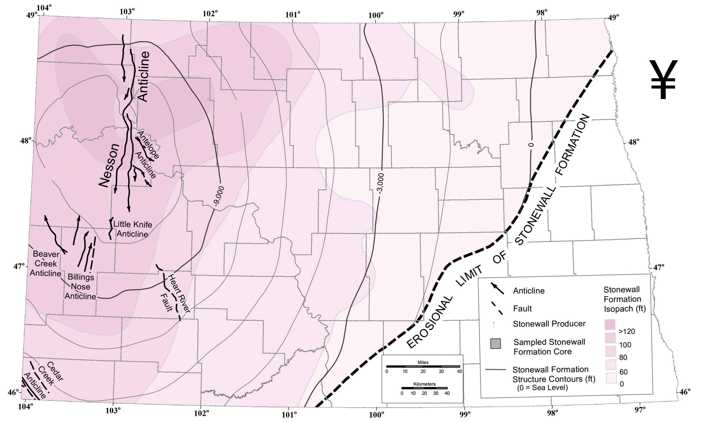
Figure 1. Map depicting the extent of the Stonewall Formation in North Dakota (colored area) (Carlson and Eastwood, 1962) and wells that have produced oil and gas from the Stonewall Formation.
Oil & Gas Resource History
An early Stonewall production test within Amerada’s Henry O. Bakken #1 (NDIC: 32, API: 33-105-00005-00-00, Sec. 12, T157N, R95W) during the early 1950s yielded gas along with 64 BBLS oil and 63 BBLS water over a 27-hour test period (Nesheim, 2015). However, the Henry O. Bakken #1 was shortly after completed with perforations in the Mission Canyon Formation (Madison Group) and commercial production from the Stonewall Formation did not take place for another 27 years (Nesheim, 2015). Commercial production from the Stonewall began in 1979 with the completion of the Rolfstad #1 (NDIC: 6680, API: 33-105-00776-00-00, Sec. 29, T155N, R100W). Since then, more than 60 vertical wells have been commercially productive from reservoirs within the Stonewall. The Stonewall oil & gas pool as defined by the North Dakota Industrial Commission includes the overlying hydrocarbon-productive reservoirs of the lower Interlake Formation with the Stonewall reservoirs. Some Stonewall Pool oil and gas wells include perforations in only the Stonewall Formation, only the lower Interlake Formation, or both.
Petroleum Geology
Hydrocarbon reservoirs within the Stonewall Formation consist primarily of dolomitized burrow-mottled mudstone-wackestone intervals positioned within the basal portions of the carbonate-evaporite cycles. Most of the Stonewall production comes from perforations in the upper member (89% of productive wells), secondarily in the middle member (16% of productive wells), and a few within the lower member (Fig. 2). The basin-centered anhydrites appear to form hydrocarbon seals. While positive structural closure plays a role with at least some Stonewall hydrocarbon accumulations, variations in reservoir quality within the burrow-mottle reservoir facies (diagenetic, stratigraphic trapping) also appears to play a role (Nesheim, 2018). The Stonewall contains variable amounts of organic-rich carbonate mudstone and may be a self-sourced petroleum system (Nesheim, 2014). G. Prisca algal microfossils have been identified within organic-rich mudstone in the Stonewall (Jubb et al., 2019), a Type I oil-prone kerogen that is a likely source of Stonewall hydrocarbons.
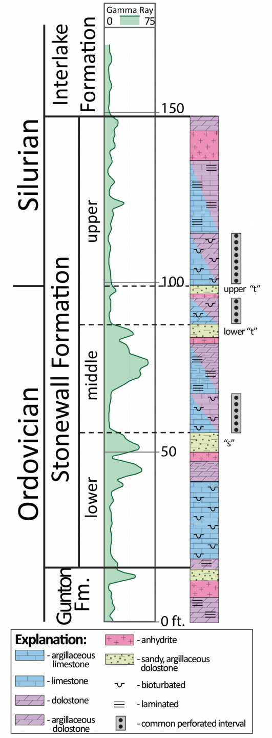
Figure 2. Example gamma ray log through the Stonewall Formation from western North Dakota with composite core-based lithologies.
Carlson, C.G., and Eastwood, W.P., 1962, Upper Ordovician and Silurian Rocks of North Dakota: North Dakota Geological Survey, Bulletin 38, 51 p. B-38
Fuller, J.G. C.M., 1961, Ordovician and contiguous formations in North Dakota, South Dakota, Montana, and adjoining areas of Canada and United States: AAPG Bulletin, vol. 45, no. 8, p. 1334-1363.
Haidl, F.M., 1991, Note on the Ordovician-Silurian boundary in southeastern Saskatchewan: in Summary of Investigations 1991, Saskatchewan Geological Survey, Sask. Energy Mines, Misc. Rep. 91-4.
Husinec, A., and Harvey, L.A., 2021, Late Ordovician climate and sea-level record in a mixed carbonate-siliciclastic-evaporite lithofacies, Williston Basin, USA: Palaeogeography, Palaeoclimatology, Palaeoecology, vol. 561, p. 1-19, doi.org/10.1016/j.palaeo.2020.110054
Jin, J., Haidl, F.M., Bezys, R.K., and Gerla, G., 1999, The Early Silurian Virgiana brachiopod beds in the northeastern Williston Basin, Manitoba and Saskatchewan: in Summary of Investigations 1999, vol. 1, Saskatchewan Geological Survey, Sask. Energy Mines, Misc. Rep. 99-4 1.
Jubb, A. M., Hackley, P. C., Hatcherian, J.J., Qu, J., and Nesheim, T.O., 2019, Nanoscale Molecular Fractionation of Organic Matter within Unconventional Petroleum Source Beds: Energy & Fuels, v. 33, p. 9759-9766. DOI: 10.1021/acs.energyfuels.9b02518
Kendall, A.C., 1976, The Ordovician carbonate succession (Bighorn Group) of southern Saskatchewan: Department of Mineral Resources, Saskatchewan Geological Survey Report no. 180, 182 p.
Nesheim T.O., 2014, Preliminary Examination of Source Beds within the Stonewall Formation (Ordovician-Silurian), Western North Dakota: North Dakota Geological Survey, Geologic Investigations No. 181, 20 p. GI-181
Nesheim, T.O., 2015, The Stonewall Formation: North Dakota DMR Geo News, vol. 42, no. 1, p. 18-20.
Nesheim, T.O., 2018, Review of Hydrocarbon Production from the Stonewall and lower Interlake Formations: Western North Dakota - Williston Basin: North Dakota Geological Survey, Geologic Investigations No. 210, 25 sl. GI-210
Stolldorf, T.D. 2020, Stonewall, Stony Mountain and Gunton Production and Drill Stem Test (DST) Maps: North Dakota Geological Survey, Geologic Investigations No. 232, 4 pl.
Last Updated: 01/12/2024.