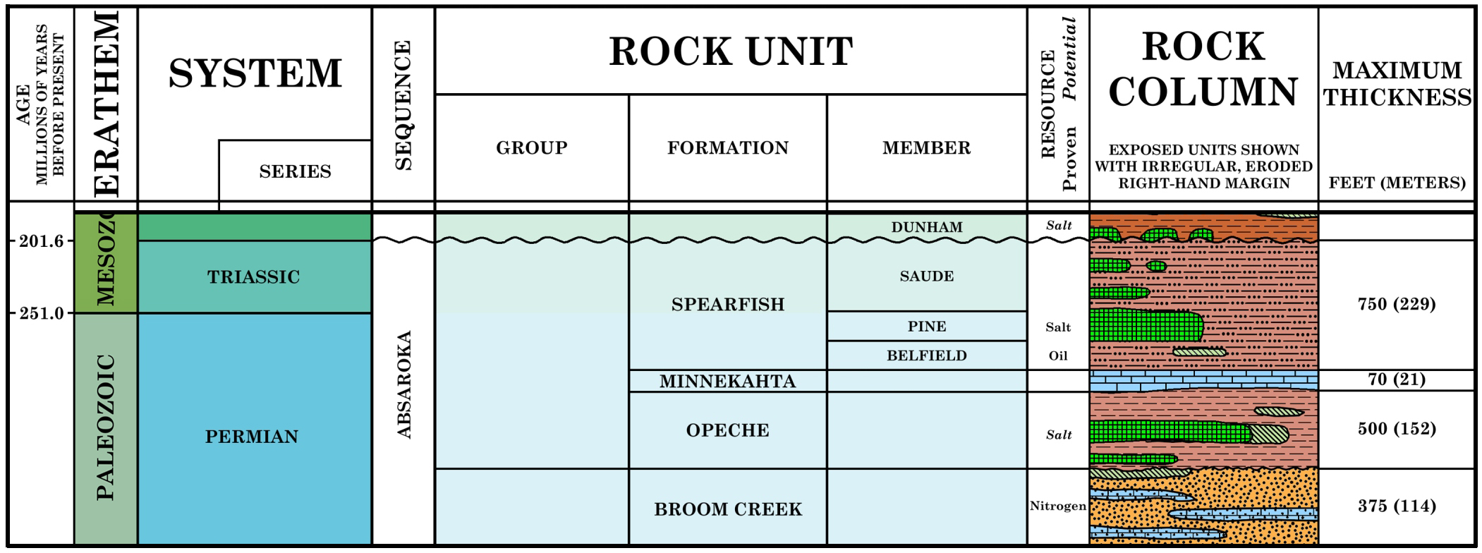
Stratigraphic column of the Opeche Formation and bounding units, modified from Murphy et al. (2009).
Originally, what is now the Opeche was lumped into an age called the Red Beds (Newton and Jenney 1880), between the Carboniferous below and the Jura (Jurassic) above. See below:
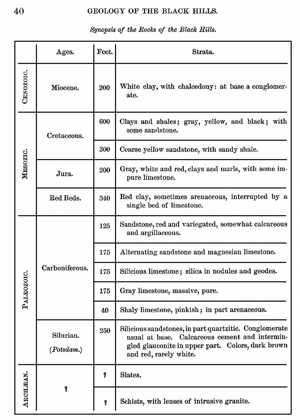
From Newton and Jenney, 1880.
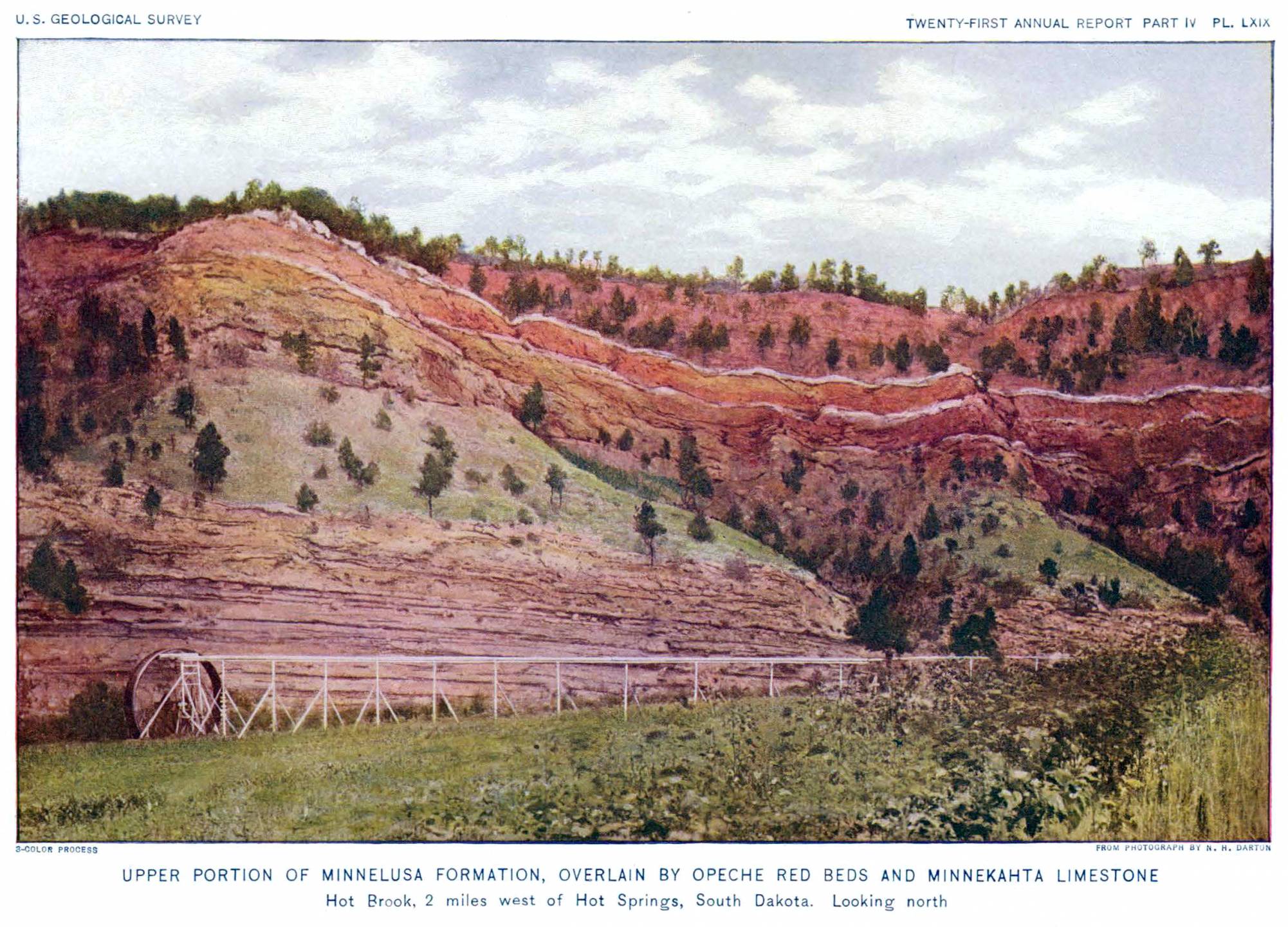
Opeche is the Native American name for Battle Creek which is in the Black Hills of South Dakota and the Opeche Formation was first named by Darton in 1901: "The name Opeche is applied to this heretofore nameless formation from the Indian name for Battle Creek, where the formation is typically developed, although not more so than at many other points in the region. The age of the formation has not been definitely determined, for so far it has yielded no fossils. From the facts that the overlying Minnekahta is Permian and that there are extensive red beds in the upper part of the Permian in Kansas and eastern Nebraska, it is supposed that it may be Permian” (Darton, 1901, p.514).
Stratigraphic Overview
Although there have been no fossils found in the Opeche Formation, there are Permian fossils below the Opeche in the Minnelusa Formation “Foraminifers collected from the USGS 2, Pass Creek core test (pl. 21) confirm the Early Permian age of unit 1 of the Minnelusa Formation in the Black Hills.” (Braddock, 1963) and Permian fossils above the Opeche in the Minnekahta Formation “Dr. John Chronic of the University of Colorado (written communications, 1958) examined material collected by the writer from the lower part of the formation (Minnekahta) and reported the following forms to be present:
Gastropods:
Bullimoroha cf. B. meeki Sayre
Sphaerodoma cf. F. fusiformis (Hall)
Pelecypods:
Nuculana cf, N. obesa White
Pleurophorous cf. P. albequus Beede
Schizodus cf. S. wheeleri Swallow
He stated: “In my opinion, the Minnekahta samples are definitely Permian.” (Braddock, 1963) bracketing the Opeche Formation within the Permian System.
The Opeche Formation is composed mainly of reddish-orange to reddish-brown to brown siltstones and claystones. The central basin area of the Opeche Formation contains significant thickness of bedded salt. Salts can also be the cements in the siltstones and claystones. The bottom of the Opeche Formation in core from the Romanyshyn 2-33-4B (NDIC# 8927, API# 3300700748) in Billings County, North Dakota is a conglomeratic lag deposit.
There are two main thick units of salt: The Opeche A salt (Chittick, 2024a) and the Opeche B salt (Chittick, 2024b). The Opeche A salt is near the top of the Opeche Formation and the Opeche B salt is near the bottom of the formation.
There are two main types of salt within the Opeche Formation: recrystallization into large crystals “chaotic halite” and bedded halite formed from evaporation out of ponded water.
Originally, the Opeche Formation was thought to be formed in a shallow restricted marine environment, but a strong case has been made to suggest that the Opeche Formation was formed in an arid continental environment. Low bromide concentrations from analyses of samples from the salt core of the Romanyshyn 2-33-4B suggest that the salts were formed in a nonmarine environment (Wilgus and Holser, 1984).
Benison and Goldstein (2000) also argued for a continental playa-type saline lake for the deposition of the Opeche Formation in North Dakota.
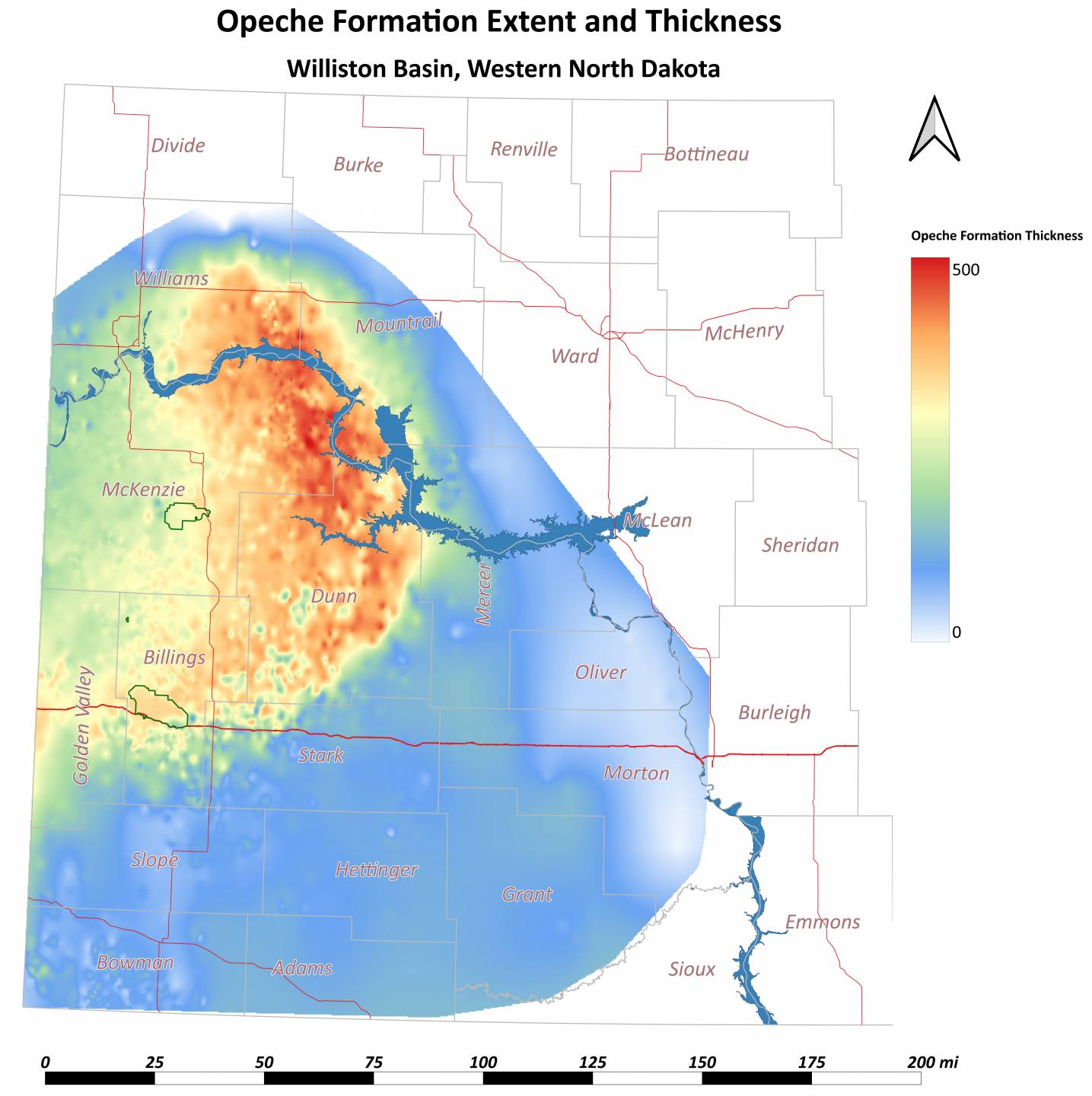
Opeche Formation extent and thickness map of Western North Dakota.
Benison, K.C., Goldstein, R.H., 2000, Sedimentology of Ancient Saline Pans: An Example from the Permian Opeche Shale, Williston Basin, North Dakota, U.S.A., Journal of Sedimentary Research, V. 70 No. 1, January 2000.
Braddock, W.A., Geology of the Jewel Cave SW Quadrangle Custer County, South Dakota. U.S. Geological Survey Bulletin 1063-G
Chittick, S., 2024a, Opeche A Salt Extent and Thickness, Williston Basin, North Dakota, North Dakota Geological Survey, Geologic Investigation GI-275.
Chittick, S., 2024b, Opeche B Salt Extent and Thickness, Williston Basin, North Dakota, North Dakota Geological Survey, Geologic Investigation GI-277.
Darton, N.H. 1901, Preliminary Description of the Geology and Water Resources of the Southern Half of the Black Hills and Adjoining Regions in South Dakota and Wyoming in the Twenty-First Annual Report of the United States Geological Survey 1899-1900 Part IV – Hydrography p. 489-599.
Darton, N.H. 1909, Geology and Water Resources of the Northern Portion of the Black Hills and Adjoining Regions in South Dakota and Wyoming. United States Geological Survey Professional Paper 65.
Maughan, E.K., 1967, Paleotectonic Investigations of the Permian System in the United States: Chapter G. Eastern Wyoming, Eastern Montana and the Dakotas. US Geological Survey Professional Paper 515-G.
Murphy, E.C., Nordeng, S.H., Juenker, B.J., and Hoganson, J.W., 2009, North Dakota Stratigraphic Column, North Dakota Geological Survey, MS-91, 1p.
Nesheim, T.O., LeFever, J.A., 2012, Three-Dimensional Geologic Model of Subsurface Salt Intervals within the Williston Basin, Northwestern North Dakota, North Dakota Geological Survey, Geologic Investigation GI-162.
Newton, H., Jenney, W.P., 1880, Report on the Geology and Resources of the Black Hills of Dakota with Atlas.
Sandberg, C.A. 1973, Salt and Potash in Mineral and Water Resources of North Dakota. North Dakota: Geological Survey Bulletin 63.
Wilgus, C.K., Holser, W.T., 1984, Marine and Nonmarine Salts of the Western Interior, United States. The American Association of Petroleum Geologist Bulletin V. 68, No.6 (June 1984) P. 765-767.
Last Updated: 11/4/2024.