Web Help
General Website Help & Navigation
Frequently Asked Questions
Surface Rights and Mineral Rights/Royalties
Oil and Gas Transfers From One Operator To Another
Directional Surveys
Does the state have guidelines for utilizing directional tools?
Yes. See the information below:
When filing certified surveys please follow these guidelines:
1. All wells must be depicted exactly as they were drilled. We require that all
original laterals and any sidetracks be kept separately, labeled as to what they
depict (e.g.: leg 1, or leg-sidetrack 1, etc.), and filed in their entirety from the tie-in
point to a projection to total measured depth of each leg or sidetrack.
2. When additional laterals and/or sidetracks are surveyed, the tie-in point should be
listed as the first survey. Do not include any surveys prior to the tie-in as they are
required to be filed with the previous lateral or sidetrack. The survey point used
for the tie-in should be the last survey run immediately above the sidetrack depth.
3. All surveys must be submitted and no surveys should be deleted at any time
unless they are outside your company's parameters for a "good survey" and cannot be corrected using an approved method.
4. Within 30 days of attaining total depth, all surveys, including the certification,
must be submitted to the Commission as one Adobe (.pdf) document to:
certsurvey@nd.gov
5. Surveys must always be corrected to True North and a notation made to that
effect.
Measurement inaccuracies need not be considered when determining compliance with the
spacing/drilling unit boundary setback requirements except in the following scenarios:
1. When the angle between the well bore and the respective spacing/drilling unit
boundary is 10 degrees or less.
2. If industry standard methods and equipment are not utilized.
3. When deemed necessary by the Director.
If measurement inaccuracies are required to be considered, a 2˚ MWD measurement
inaccuracy is applied to the well bore from the KOP to TD and is calculated by
multiplying the tangent of 2˚ (which equals 0.03492) by the corresponding coordinate
distance. The new setback can be calculated at any point by taking the distance
traveled north/south times the tangent of 2˚ and adding it to the east/west setback or
taking the distance traveled east/west times the tangent of 2˚ and adding it to the
north/south setback. (*Tool error will not be considered if a 1220' setback is
applied).
The requirements for surveying horizontal well bores are as follows:
1. Directional surveys are required at least 30' in the build section (or when steering
the well) and at least every 90' in the lateral portion of the well bore while
rotating. A waiver to the 30' survey interval may be obtained if 45' drill pipe is
utilized.
2. Gyro surveys are required at 100' intervals on all cased hole re-entry operations.
3. Directional surveys are required at 100' intervals in the vertical portion of the
well bore with the tie-in point located at the surface casing shoe except in the
following cases:
a. Tie to the surface if an MWD tool or GYRO is run from surface.
b. Tie in at 30' below surface casing shoe if a continuous directional log is
run (e.g. Schlumberger GPIT log).
4. Lastly, proper magnetic spacing must be maintained in order to insure azimuth
accuracy.
If I am a directional drilling contractor and own directional tools do I need to be pre-approved by the state?
Yes, we require all directional contractors to be registered by the Secretary of State. In addition, the owner of the directional tool must submit tool specifications to ensure industry standards are being utilized.
How soon does the owner of the directional tool need to send in the certified survey after the well attains total depth?
Specifically pursuant to NDAC 43-02-03-25 "The survey contractor shall file with the director free of charge one certified electronic copy of all surveys, in a form approved by the director, within thirty days of attaining total depth. Such survey shall be in reference to true north".
Seismic
Does the State collect actual data from the Geophysical Contractor?
No. We do not collect recorded data, as that information is highly confidential and utilized by geophysicists to help accurately depict formation structure within the project area.
Do I need to email a map along with my Geophysical Project Permit?
Yes. All permits require an electronic copy of the preplot map to include a topo layer in relation to the source and receiver points.
Production
Where do I find monthly production statistics?
Production information for individual wells, fields and units may be obtained through the subscription service on our web site, or you can view the PDF or Excel version (where available) of the monthly production report free of charge.
Where do I find production and injection forms?
Production and injection forms are located here: North Dakota Oil and Gas Forms page.
How do I report production or injection online?
The instructions for setting up online production and injection reporting are located here: North Dakota Oil and Gas Division eFile page.
How do I find total production for all wells?
If you have a basic subscription, click on the "well Index" button on the left side menu and download the well_index.zip file, which is an Excel spreadsheet. Under the 'OilWaterGasCums' column the total oil, water, and gas volume is separated by the pipe (|) symbol. Multiple formations are separated by a comma. This file is also available in the premium subscription area by clicking the "Well Index & Downloads button.
How do I find total production for an individual well?
Both the Basic and Premium Subscription areas have a "Well Production" button on the left side of the page. Clicking this will take you to a form where you can input the well number and see production data for that well.
What is the current gas capture policy?
You can find ND gas capture policy information on the North Dakota Oil and Gas Division's Policy Page.
General Web Help
Why do PDF documents sometimes open up as a blank page?
This is caused by using an out of date version of Adobe Acrobat Reader that cannot read the newer PDF file versions. Please upgrade your Acrobat Reader to the latest version which is available from the www.adobe.com web site. It is a good practice to keep all of your web browser plugins up to date.
Why do some of the TIF log images open up blank or as a narrow strip?
This problem usually occurs because the TIF image viewer you are using cannot handle the large image dimensions of the scanned image. While most picture and fax viewers can handle large file sizes, large file dimensions are all together different. Most image viewers are designed to handle pictures and faxes. The page dimensions of these images are usually 8-1/2 by 11 inches or smaller.
Scanned logs can have image dimensions exceeding 100 feet in length. To put this in perspective, take a 100 foot long log image scanned at 300 DPI (dots per inch) and you get an image 360,000 pixels long. To get a 360,000 pixel long image from an 11 inch piece of paper, you would have to scan it at 32,727 DPI. You may need to install a third party viewer that can handle these large dimensions. If your image viewer does not have a plugin for your web browser, save the TIF image to your computer first and then open it with your viewer. To save the image to your computer with Microsoft Internet Explorer, right click on the link and choose "Save Target As..." from the drop down menu.
How to change the cache/clear temporary files from browser?
To clear temporary files from your browser please follow the directions below depending on your browser:
Internet Explorer:
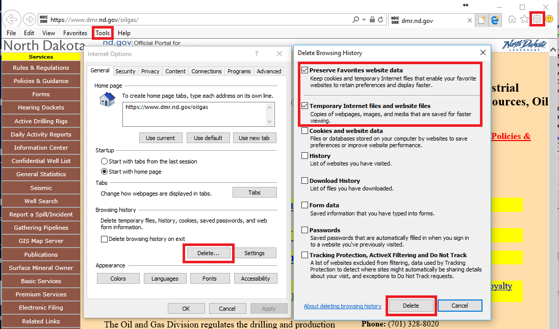
- Click on the Tools menu (gear icon in the top-right of the browser window).
- Select "Internet Options" from the drop-down. On the "Internet Options" menu click the Delete button under the Browsing history section, which will open the "Delete Browsing History" window.
- Make sure both the "Preserve Favorites website data" and the "Temporary Internet files and website files" options are selected then click the Delete button.
- Close all open browsers and reopen IE to test.
Google Chrome:
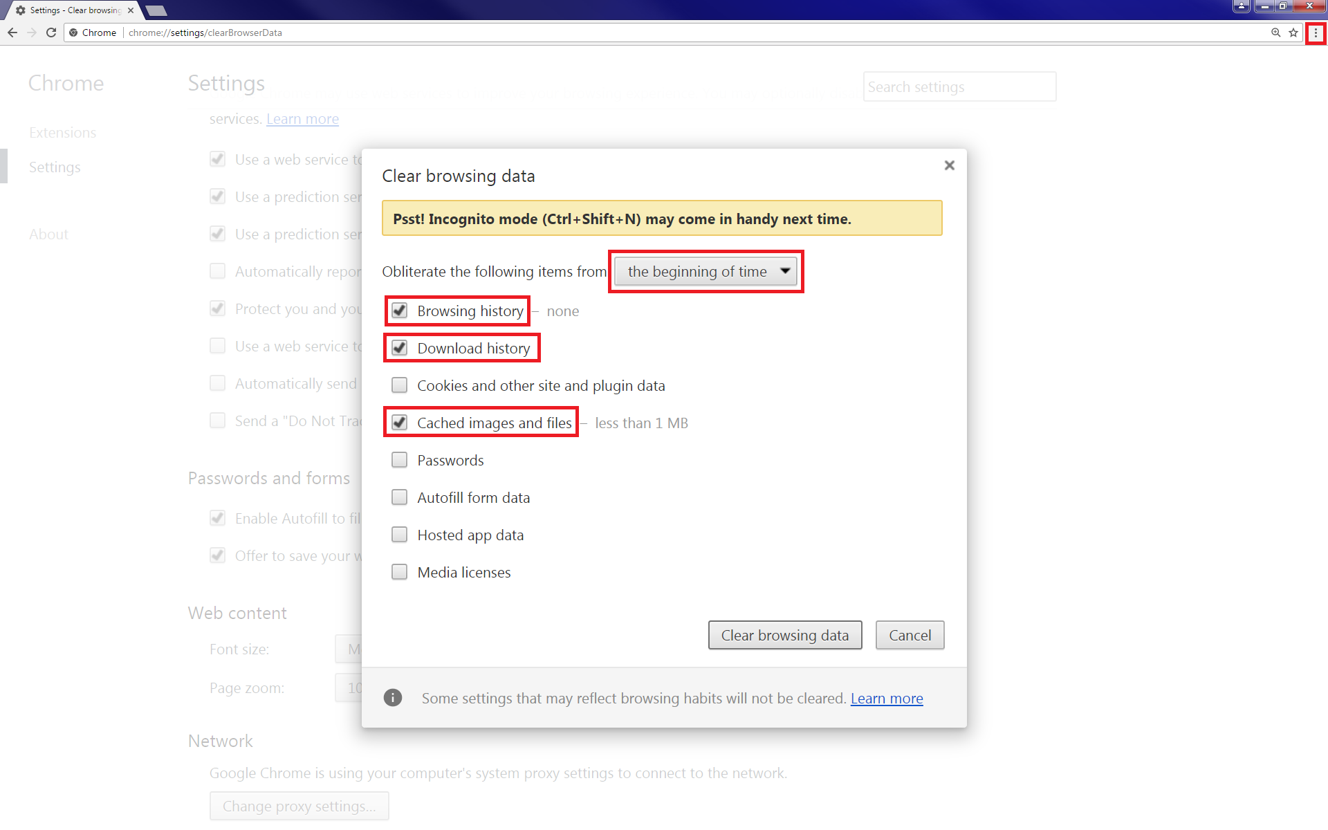
- Click on the Customize and control google Chrome menu (three dots in a vertical line in the top-right of the browser window).
- Select "History" from the drop-down and then "History" again on the next drop-down. On the "History" window click the "Clear browsing data" option on the left-side of the browser.
- Make sure "the beginning of time option" is selected from the "Obliterate the following items from" drop-down, also make sure the "Browsing history", "Download history", and "Cached images and files" options are selected then click the Clear browsing data button.
- Close all open browsers and reopen Chrome to test.
To change how your browser stores copies of webpages, images, media, etc. please follow the directions below depending on your browser:
Internet Explorer:
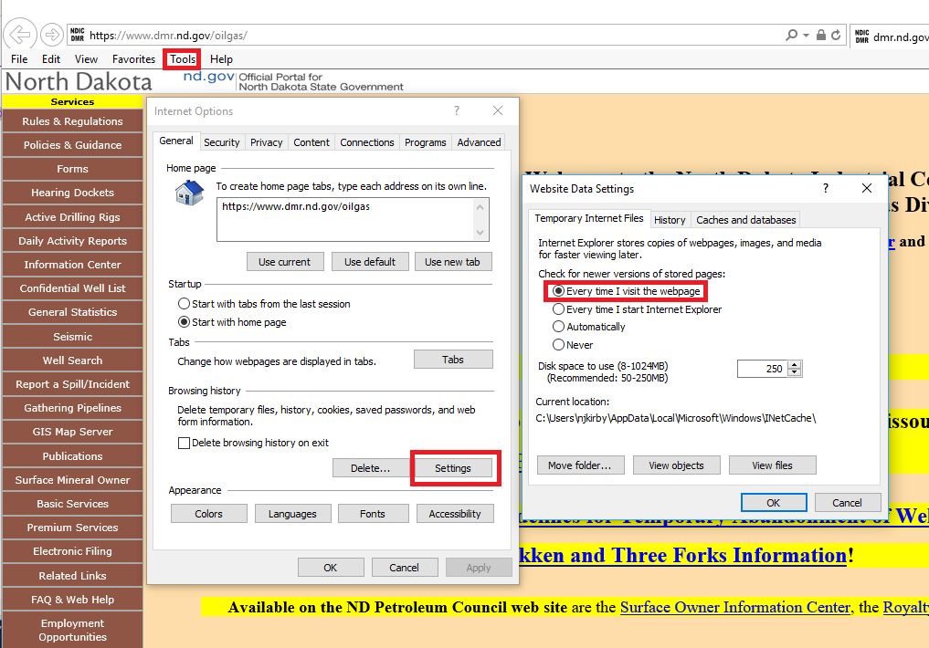
- Click on the Tools menu (gear icon in the top-right of the browser window).
- Select "Internet Options" from the drop-down. On the "Internet Options" menu click the Settings button under the Browsing history section, which will open the "Website Data Settings" window.
- Under the "Temporary Internet Files" tab make sure the "Every time I visit the webpage" option is selected then click the OK button. Select the OK button on the "Internet Options" menu.
- Close all open browsers and reopen IE to test.
Google Chrome:
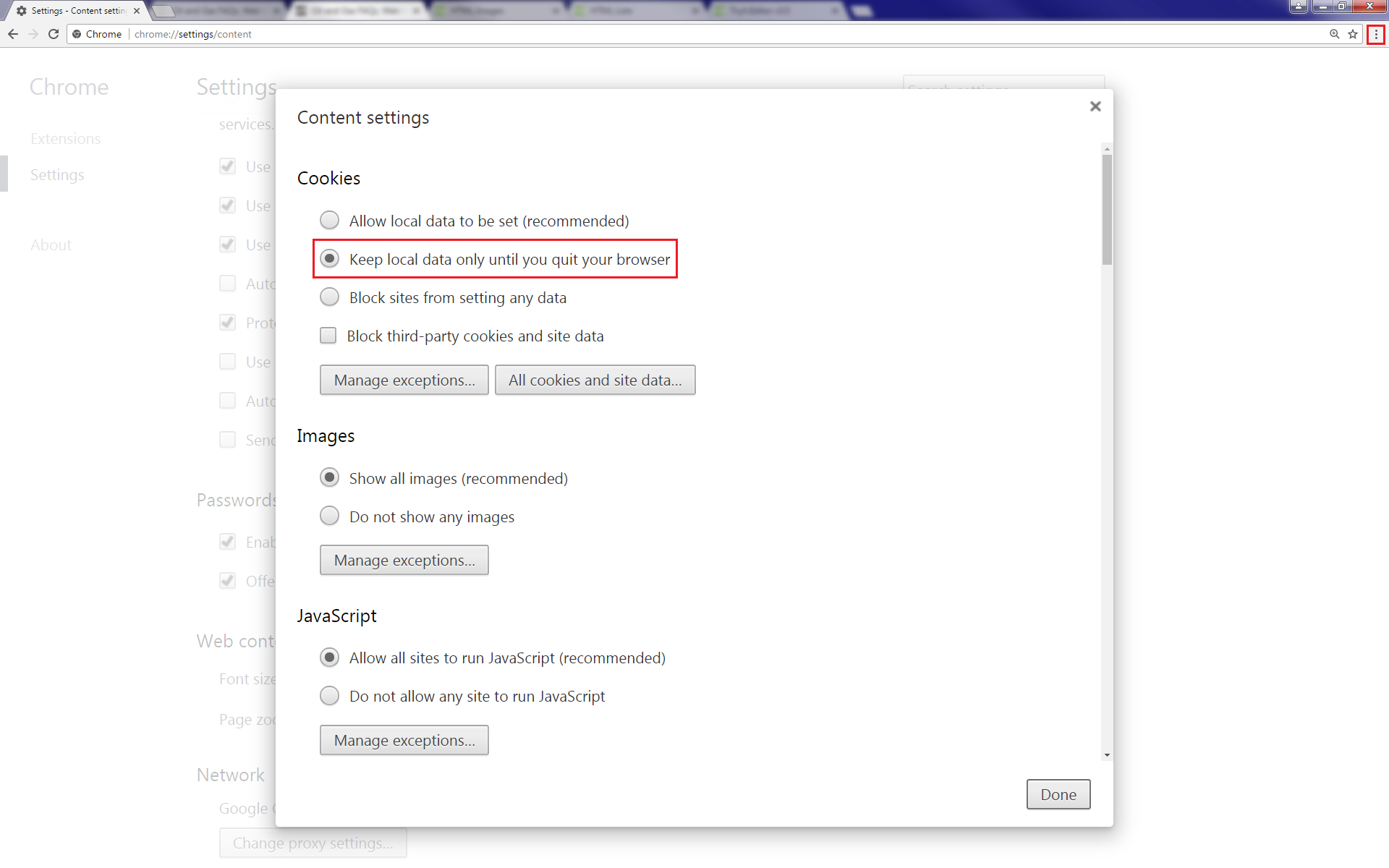
- Click on the Customize and control google Chrome menu (three dots in a vertical line in the top-right of the browser window).
- Select "Settings" from the drop-down. On the "Settings" menu scroll down to the bottom of the page and select "Show advanced settings...".
- MUnder the Privacy section click the Content settings... button. On the "Content settings" menu under the Cookies section make sure the "Keep local data only until you quite your browser option" is selected and then click the Done button.
- Close all open browsers and reopen Chrome to test.
|
 ]
]