[ ]
]
[]

|
Small hills found in some parts of southeastern North Dakota have a superficial resemblance to volcanoes, and the way they formed is somewhat analogous to volcanic processes. The features,
known informally as "veblens," formed as a result of geologic processes known as hydrodynamic blowouts. You probably haven't heard of veblens. Veblens are not the result of molten rock erupting upward from the earth's interior as is the case with volcanoes. In fact, no heat was involved. Rather, veblens formed when groundwater flowed upward from pressurized aquifers, carrying with it large amounts of sand and gravel as it rose. In some places, where the sand-and-gravel laden water exited to the surface through cracks in the glacial ice, the sand piled up on the ice, and when the ice melted, it slumped down to form small, cone-shaped hills. Dr. Kenneth Harris, a former North Dakota Geological Survey geologist now at the Minnesota Geological Survey, first recognized these features in 1984 while mapping the geology along the South Dakota border in southeastern North Dakota. He noticed several small hills and referred to them as "veblens," after the town of Veblen, South Dakota. The veblens in southeastern North Dakota are from 40 to 70 feet high and most of them are about 0.1 to 0.2 mile across. Ken mapped about 50 veblens in southwestern Richland and southeastern Sargent counties, in the Lidgerwood - Geneseo area in 1987 (see photos). 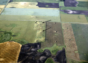 Oblique air view of veblens about three miles southwest of Geneseo, Sargent County, North Dakota. This veblen is in Section 27, T. 130N., R. 53W., and is up to 40 feet high. The view is to the south. 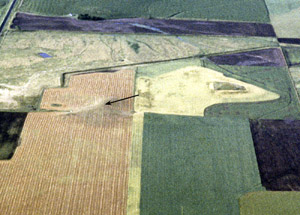 Oblique air view of a veblen about three miles south of Geneseo, Sargent County, North Dakota. The veblen is just to the left of center in photo is about 40 feet high. It is in Section 35, T. 130N., R. 53W. The only other geologic features that might be mistaken for veblens are glacial hills known as kames. However, kames consist of gravel and sand deposited by streams that flowed into holes in the glacial ice, depositing sediment in the holes. When the ice later melted, the materials slumped down, often forming conical-shaped hills. Thus, kames are formed "from above," veblens "from below" (diagram "A" showing difference in the origin of these two kinds of features ). 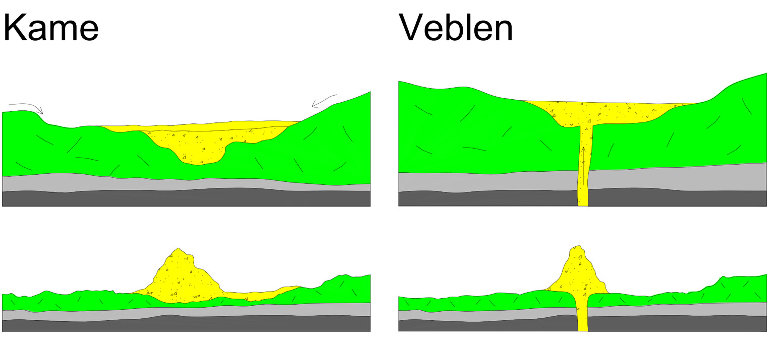 A. Diagrams showing the difference in the way kames and veblens form. The two diagrams on the left show how a kame forms. A kame is formed when sand and gravel are carried by streams on top of or within the ice and delivered to a depression or crevasse in the glacier. When the ice melts, the sand and gravel slump down to their angle of repose, sometimes forming a cone-shaped hill. The two diagrams on the right illustrate the formation of a veblen. Sand and gravel are delivered upward through a hydrodynamic blowout into a low area or crevasse in the glacier ice. When the ice melts, the sand and gravel slump down to their angle of repose, sometimes forming a cone-shaped hill. The difference is in the source of the fluvial materials - the sand and gravel. In kames, the fluvial materials are delivered from above. In veblens, the fluvial materials are delivered through hydrodynamic blowouts, and a core (a “clastic plug”) extends downward to the underground source. In North Dakota, veblens occur in places where groundwater under pressure escapes to the surface, mainly in the eastern part of the state. The best-known artesian aquifer in North Dakota is the Dakota Formation sandstone, which underlies nearly the entire state. The Dakota Formation is of Cretaceous age. However, several other formations beneath the Dakota, mainly Paleozoic units, also contain water and these deeper units may behave in a way similar to the Dakota Formation aquifer. In most of the state, the aquifers are sufficiently covered - sealed - by shale, so that the water they contain cannot escape upward. In the easternmost part of the state though, especially in the Red River Valley where the shale seal is discontinuous and missing in places, salty groundwater is constantly escaping to the surface. Diagram B shows how veblens are thought to have formed. 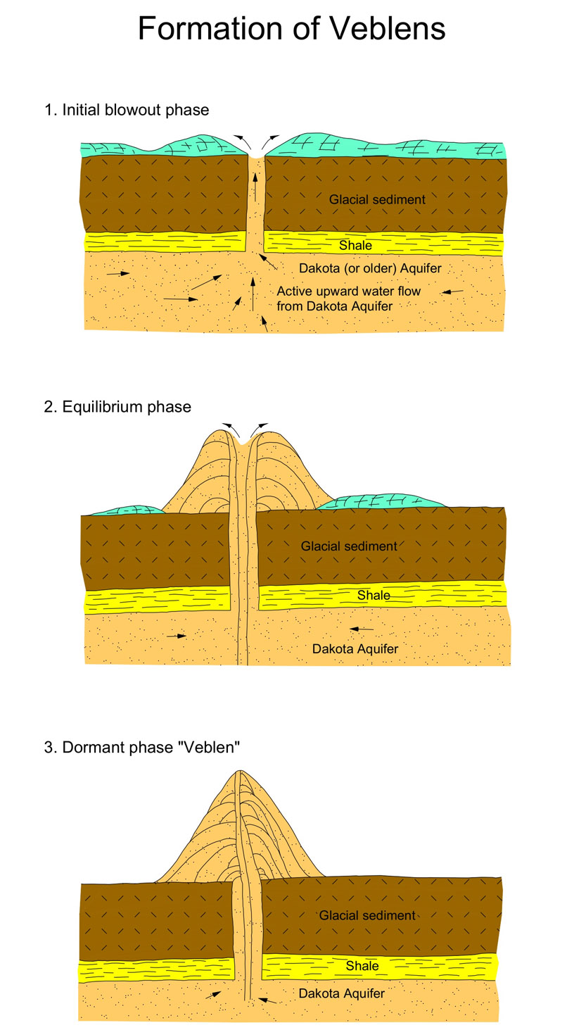 B. Generalized, hypothetical cross sections showing how hydrodynamic blowouts may have formed in southeastern North Dakota. Groundwater transported sand and gravel upward, depositing it above the surface vent, resulting in a veblen or sand volcano. Arrows show flow directions of groundwater. The normal flow directions ("normal" being times like today; times when glaciers didn't cover the northern plains and provinces in the Williston Basin) are generally from southwest to northeast (from the area of the Black Hills to the outcrop areas in the eastern Dakotas and southeastern Manitoba). However, during the several times that the area was extensively glaciated, the direction of groundwater flow was reversed. The glaciers generally laid upon unfrozen sediment and, in fact, there were probably "lakes" of meltwater at the base of the glacier - between the overlying ice and the underlying sediment. In areas where the sediments beneath the glacier ice were permeable (water could move through them), in places where this water could not escape beneath the ice to the edge of the glacier, the tremendous weight of the overlying glacier forced water into the ground, overpowering the previous (pre-glacial) groundwater flow paths. During the thousands of years that glaciers covered the area, water was forced into the ground and regional flow paths were reversed so that groundwater flowed toward the Black Hills and fresh, glacial-derived water was forced into the ground for several hundred miles southwestward (toward the Black Hills). Hydraulic pressures in the buried aquifers built up greatly during that time. Only when the glacier melted, and the weight of the overlying glacial ice disappeared, were the original, preglacial groundwater flow paths re-established. When the glaciers melted, the overlying pressure was removed so that large quantities of water were able to flow upward out of the aquifer. These flows of water resulted in hydrodynamic blowouts (Diagrams C and D). The upward flow of water through the overlying materials was rapid at first and carried sand and other sediment with it. This was probably when the veblens formed. In some places, the blowouts resulted in erosion of the glacial Lake Agassiz sediments forming depressions in which lakes exist today.  C. Generalized cross-section showing how a hydrodynamic blowout can develop. Such blowouts may result in hills of sand (“veblens”), or pools of water. During the initial blowout phase (top diagram), water flowing upward from an artesian aquifer, such as the Dakota Sandstone, under high pressure transported sand and gravel. During later stages of development, the conduit became larger so that the upward-flowing water moved under less pressure and was less able to transport material. 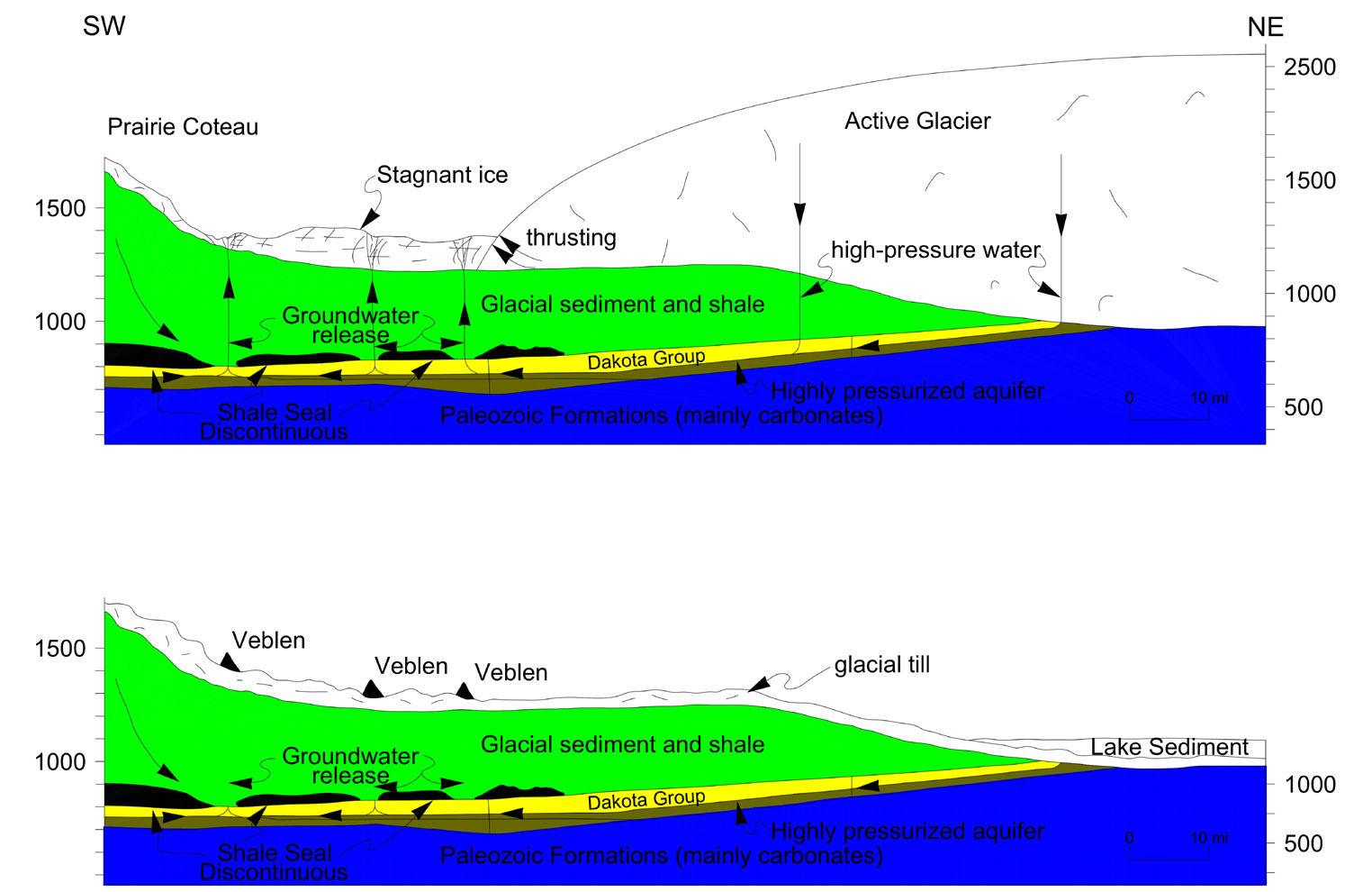 D. Generalized cross-section showing local groundwater flow lines beneath and in front of a glacier. The upper illustration represents hydrologic conditions at the time hydrodymanic blowouts formed between the active glacier (to the northeast) and the Prairie Coteau (to the southwest). The lower illustration represents the current situation, with the glacial ice melted. The sand-filled blowouts in the stagnant ice have collapsed to their angle of repose - to roughly cone-shaped hills (“veblens”). Modern hydrodynamic blowouts can occur in a variety of situations. They may be initiated when a drill hole penetrates a confined, high-pressure aquifer. Despite efforts to contain the resulting flows, such drill holes sometimes flow out of control or they may even "blow" out with considerable force (similar blowouts can happen when oil or gas wells are drilled, and zones of high-pressure fluids - liquids or gases - are encountered). The flows may continue for several months, or even years, resulting in considerable amounts of water and washed material being carried upward to the surface of the ground. ReferencesBluemle, J. P., and Clayton, L., 1984, Large-scale glacial thrusting and related processes in North Dakota: Boreas 13, 279 - 299 p. Bluemle, J. P., 1993, Hydrodynamic blowouts in North Dakota: in Aber, J. S. (ed), Glaciotectonic and Mapping Glacial Deposits: Proceedings of the INQUA Commission on Formation and Properties of Glacial Deposits: Canadian Plains Research Center, Univ. of Regina, 259 - 266 p. Bluemle, J. P., 2000, The face of North Dakota, Third Edition: North Dakota Geological Survey Educational Series 26, 206 p. Christiansen, E. A., Gendzwill, D. J., and Meneley, W. A., 1982, Howe Lake: A hydrodynamic blowout structure: Canadian Journal of Earth Sciences 19, 1122 - 1139 p. Downey, J. S., 1969, in Peterson, D. T., and Reid, J. R. (eds.), Geology of northeastern North Dakota: North Dakota Geological Survey, Miscellaneous Series 39, 30 p. Downey, J. S., Busby, J. F., and Dinwiddie, G. A., 1987, Regional aquifers and petroleum in the Williston basin region of the United States, in Peterson, J. A., et al. (eds), Williston basin: Anatomy of a cratonic oil province: Denver, Colorado, Rocky Mountain Association of Geologists, 299 - 312 p. Grasby, S. E., Osadetz, K. G., Betcher, R., and Render, F., 2000, Reversal of the regional-scale flow system of the Williston Basin in response to Pleistocene glaciation: Geology 7, 635 - 638 p. Harris, K. L., 1987, Surface geology of the Sheyenne River map area: North Dakota Geological Survey, Atlas Series Map 15. Laird, W. M., 1944, The geology and ground water resources of the Emerado quadrangle: North Dakota Geological Survey Bulletin 17, 35 p. Additional article: Sheldon's Outlaw Well |