[ ]
]
[]

Before North America was first glaciated during the Ice Age about two million years ago, all of the rivers in North and South Dakota and eastern Montana drained northeastward into
Canada to Hudson Bay. There was no Missouri River carrying drainage from the northern mid-continent to the Gulf of Mexico (my definition of the Missouri River requires that it flow
to the Gulf of Mexico). Why is the modern situation so different than it was two million years ago?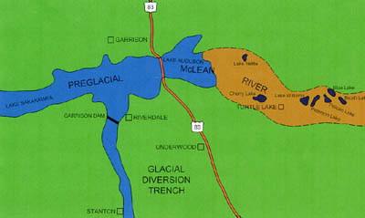 Schematic map showing a portion of the route of the preglacial “McLean River,” which flowed eastward through a broad valley that passed between Garrison and Riverdale, to the Turtle Lake area, and on into Sheridan County. When the McLean River valley was blocked by a glacier, a proglacial lake formed in the valley. When the lake overflowed southward from a point near Riverdale — at the site of the modern Garrison Dam — a narrow diversion trench was cut. The modern Missouri River flows through this diversion trench. 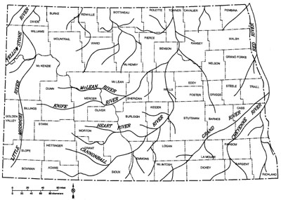 The west-east segments of the Missouri River Valley are wide because they coincide with much older valleys, some of which had already existed for a long time prior to glaciation. Old or mature river valleys tend to be broad with gentle slopes. Younger immature valleys are usually narrower with steeper sides. Map of North Dakota showing the drainage pattern prior to glaciation. All rivers flowed north or northeast into Canada. The Missouri River valley did not exist (except for short segments that correspond to portions of valleys such as the Knife and McLean River valleys — see text). Another west-east trending segment of the modern Missouri River Valley is the one between Stanton and Washburn. This is an eastward continuation of the modern Knife River. Prior to glaciation, the Knife River flowed east past Washburn, turning slightly northeastward there. It joined the McLean River in eastern McLean County near the town of Mercer. The Knife-McLean River continued northeastward to the Devils Lake area, then north along the east side of the Turtle Mountains into Canada (remember, all of this was before North Dakota was glaciated).  View over the Missouri River south of Riverdale, McLean County, North Dakota (Photo by J. Bluemle). 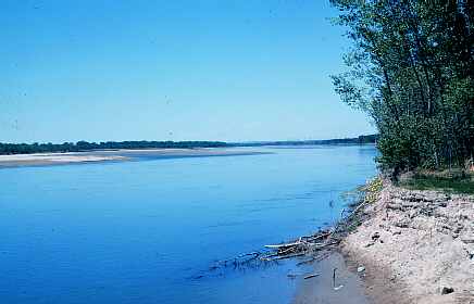 Westward view of the Missouri River, 2 miles west of Washburn, North Dakota (Photo by J. Bluemle). To summarize the situation at Bismarck-Mandan: the Missouri River Valley north of the two cities is much younger (formed during a glacial event, perhaps 25,000 years ago) than is the valley several miles south of the city, where it coincides with - crosses - the old, preglacial northeast-trending Heart-Little Heart valley. I've been discussing several of the wide, east-west segments of the Missouri River Valley. Most of the narrow, north-south segments of the valley formed in places where glaciers diverted rivers southward. North Dakota was glaciated about a dozen times during the Ice Age and most of the glacial activity tended to be concentrated in the eastern and northern parts of the state. However, each time glaciers advanced southward through the Red River Valley and other parts of eastern North Dakota, they also expanded westward and southwestward, causing what had been northeasterly flowing rivers to be diverted along the western margin of the glacier. When the McLean River was blocked by a glacier in the Riverdale area midway through the Ice Age, a large, proglacial lake formed ahead (to the west) of the ice in the valley of the McLean River. This was the "original" Lake Sakakawea - an early ice-dammed lake that predated the Corps of Engineers version of Garrison Dam by a few hundred thousand years. Eventually, the proglacial lake overflowed (there was no spillway) just about where Garrison Dam is today, and the resulting flood quickly carved a narrow trench southward to the Stanton area (kind of an early Garrison Diversion Project - those glaciers moved slowly, but at least they got the job done!). But, at the same time this was happening, the Knife River Valley was also flooded, dammed by glacial ice in the Washburn-Wilton area. The lake in the Knife River Valley, in turn spilled southward into the Burnt Creek-Square Butte Creek drainage, carving a narrow trench from just south of Wilton to Bismarck-Mandan. It's possible these events took place quickly - kind of a domino effect, but we don't really know. 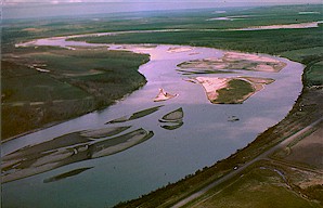 View of the Missouri River, south of Bismarck (Photo by J. Bluemle). 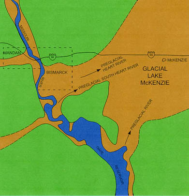 Schematic map showing the Missouri River Valley at Bismarck-Mandan. South of Bismarck, the valley is very wide because it corresponds to the old, northeast-trending preglacial valley of the Heart River. North of Bismarck-Mandan, the valley is narrow with quite steep sides. This portion of the valley was formed when an ice-dammed lake to the north in the preglacial Knife River valley overflowed from a point near Wilton. A similar ice-dammed lake existed in the Heart River Valley east of Bismarck — the glacial Lake McKenzie. 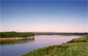 View looking north along the Missouri River, ten miles north of Bismarck. (Photo by J. Bluemle) 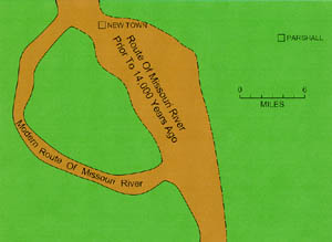 Schematic map showing the old route of the Missouri River at New Town (within the dashed lines) and the more recent route, formed when the glacier diverted the river farther southwest (within the solid lines). This diverted loop of the Missouri River is the youngest portion of its valley through North Dakota. It formed about 14,000 years ago. 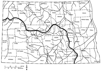 At different times during the Ice Age, various routes were followed by the major river that drained the northern plains (the “Missouri River”) southward. The route shown here is problematical, although entirely possible and as good a guess as any of nearly countless other possible routes. Certainly the “Missouri River” followed routes similar to the one shown here (heavy, dark line) at various times during the Ice Age. To sum up: the modern Missouri River Valley is a "composite" of old, wide pre-glacial valleys and younger, narrower valleys that were cut at various times during the Ice Age. The parts of the Missouri River Valley that extend west-east are generally wider and these are the older segments. The parts that extend north-south are generally narrower and younger. Even though many other earlier versions of the Missouri River existed during the Ice Age in eastern North Dakota, most of them were later buried beneath thick deposits of glacial sediment. The modern Missouri River Valley is simply the latest in a continuing series. After the next glacier has come and gone, the "new" Missouri River will undoubtedly follow a different route than it does today. 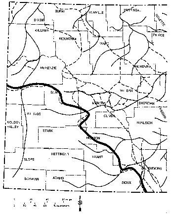 Each time North Dakota was glaciated, diversion trenches formed along the ice margin as it stood in various positions. In most of eastern and northern North Dakota, these diversion trenches, shown by dashed lines, are now buried beneath thick glacial deposits. However some of them in the southeastern part of the state are still prominent features, valleys without rivers. This map illustrates the southwestern most route of an early “Missouri” River (heavy, dark line) and fo02-Jan-2008expression is the modern Killdeer-Shields Channel, which extends from the Killdeer Mountains, southeastward to Sioux and Emmons counties. |