[ ]
]
[]

Eskers are among the more interesting kinds of glacial deposits found in North Dakota. They were deposited by streams and rivers that flowed on top of the glacier, in cracks in the glacier or,
in some cases, in tunnels beneath the ice. Imagine a river flowing in a valley or crack in the glacier. The banks of the river were ice and, in some places, the floor was also ice. These
Ice-Age rivers and streams deposited gravel and sand in their ice valleys, just as a modern stream deposits sediment in its valley. The very important difference is that the banks of the esker
rivers eventually melted away, leaving the gravel deposits standing as ridges, a complete reversal of topography. What had been a valley became a ridge. The landscape has become inverted; it is
"upside down" from what it was when it was forming. 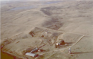 Esker near the Hurdsville Roundhouse, Wells County (photo by J.P. Bluemle). Typically, the gravel found in eskers is coarse and contains layers and lenses of silt and clay. The gravel typically contains fine and coarse materials mixed together so that the quality of the gravel is usually not suitable for construction purposes. One of the reasons for this is that, while the glacier was melting, debris contained in the ice melted out and slid, in the form of mud flows, into the streams, becoming mixed with the stream sediment. Cobbles and boulders also slid off the ice into the streams. These can be seen today, mixed in with the stream sediment and littering the surfaces of the eskers. Easily the most prominent esker in North Dakota, and in fact one of the most outstanding examples in North America, is the Dahlen Esker, which is located midway between Fordville and Dahlen in the northeastern part of the State. It can be seen as a prominent ridge where State Highway 32 crosses the Grand Forks-Walsh County line. Look off to the west from the highway and, if the weather is reasonably dry, you can drive about a mile to the crest of the esker. The short drive off the highway is well worth it. 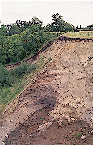 Cut in an esker near Homme Dam, Walsh County (photo by J. P. Bluemle). The Dahlen Esker was deposited by a meltwater stream flowing in an ice-walled channel, most likely a tunnel, near the edge of the glacier. The stream probably flowed from east to west, toward the margin of the glacier. The stream flow direction, although suggested mostly by the position of the glacier margin, may be indicated by a hill of gravel near the northeast end of the esker; this hill may mark the point where water flowed from the surface of the glacier through an opening to a tunnel or ice-walled river channel. 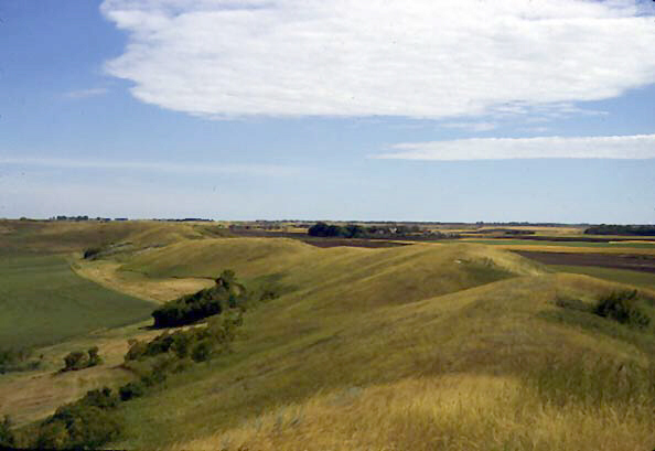 Dahlen Esker, Grand Forks County (photo by J.P. Bluemle). One area where eskers are particularly abundant is in Towner County, east of the Turtle Mountains. Hundreds of small esker segments are found in that area, along with a few larger ones. An especially well-developed esker system extends from north to south through central Towner County. When viewed on air photographs, it can be seen that the eskers in this system, which appear as light-colored lines, are cris-crossed by numerous thin, black lines. These black lines are bison trails, formed over a period of time by herds of animals crossing the ridges. The animals used the same route repeatedly, on their way to water or around lakes or sloughs, resulting in well-defined trails (see North Dakota Note No. 2). Other notable eskers can be found about ten miles south of Tolna in southwestern Nelson County, near Benedict in northeastern McLean County, about ten miles southwest of Carrington in Foster County, east of Dazey in Barnes County, and in northern Sheridan County. 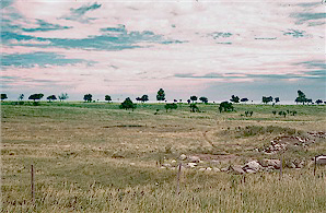 Trees growing on an esker near Lankin, North Dakota (photo by J.P. Bluemle). Eskers, of course, occur in areas that have been glaciated. However, features very similar in appearance to eskers are found in some parts of southwestern North Dakota that have not been glaciated. These ridges, which are informally referred to as "gorhams," may have dimensions similar to typical eskers, about a hundred feet high, 300 to 600 feet wide, and several miles long. However, gorhams are typically less winding than eskers. Gorhams are differential erosion ridges. Like eskers, they are commonly composed of gravel. They formed as channel stream deposits that were originally incised into the nearby bedrock. Rainfall infiltrated into the sandy soil of the gravel channels more easily than into the adjacent clayey soil, resulting in less runoff and less slope-wash erosion on the channel (ridge) deposits. This resulted in topographic inversion of the local landscape, the channels becoming ridges, whereas the less-resistant materials of the uplands between the channels was transformed to lowlands. The stream gravels were left standing as ridges marking the old routes of the streams that had deposited them. Nearly all eskers in North Dakota were formed during the Late Wisconsinan glaciation so they are generally between about 20,000 and 12,000 years old. Gorhams are much older and took much longer to form. They may date to early Pleistocene or Pliocene time, perhaps as old as several million years old. Eskers and gorhams form in entirely different ways, but the outward results can be very similar. 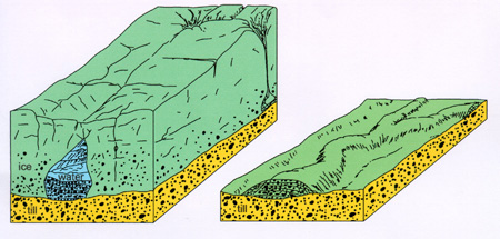 The diagram shows how an esker is formed when a stream of meltwater carrying sediment develops beneath a glacier (or, in some instances, in an open crack in the glacier). Such a stream may meander a little as it winds its way underneath the glacier toward the front of the ice. The sand and gravel is deposited when the meltwater gradually slows and drops its sediment load. When the ice melts away; the fluvial sediment is left as a long, narrow, winding ridge, which marks the course of the former subglacial stream. 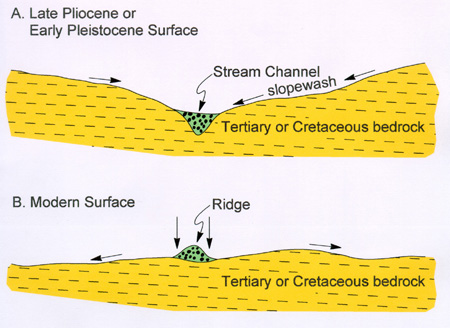 Development of a differential-erosion ridge in southwestern North Dakota. Late Tertiary or Pleistocene stream erosion of the bedrock surface resulted in gravel and sand being deposited in channels (upper diagram, A). Continued erosion (lower diagram, B) was differential, attacking the bedrock surface with runoff and slopewash while infiltrating into, but not eroding, the channel gravel deposits (see discussion in the text). This resulted in inversion of the topography and the formation of the ridges of gravel and sand, which may be up to thirty or forty feet high, a tenth of a mile wide, and a mile or more long. The ridges have been informally referred to as "gorhams." |