Several volcanic ash beds or tuffs are known to be present in western and central North Dakota. These tuffs range in age from 70 to 20 million years and are believed to have originated from volcanoes
in south-central and western Montana and northern Wyoming. Numerous additional volcanic ash beds are likely present in the Pierre and Niobrara formations but most, if not all, of the glass shards have been
altered to bentonitic clay. These tuffs generally are thought to be the result of single or related airfall events that likely deposited a rather thin layer of volcanic dust across a wide area. In turn this
volcanic dust was transported by wind and rain into streams and redeposited in local basins, commonly lakes, as thick tuffs. As a result of this reworking, an inch or less of volcanic dust may result in 20 feet
or more of tuff. The glass grains or shards in tuffs have been used in the manufacture of road base construction, concrete admixtures and aggregates, abrasives, cleansers, polishing compounds, slow release
fertilizers, ceramics, absorptives, and fillers.
Tuffs have been discovered in Emmons, Sioux, Stark, Dunn, Slope, and McKenzie counties. The most well known tuff deposit is the Linton Ash which has been actively promoted for a period of
twenty years but has undergone little development.
The Linton Ash is well exposed in the hills north of the town of Linton in Emmons County. The Linton Ash occurs in the lower part of the Fox Hills Formation and consists of
25 feet of fine grained, moderately indurated tuff. There is approximately 500 million tons of ash in a 4,000 acre area around Linton. (Photo by E. Murphy, NDGS).
The Marmarth Ash, in the foreground, is present in the uppermost part of the Hell Creek Formation northeast of the town of Marmarth in Slope County. The Marmarth
Ash consists of approximately 6 feet of unaltered (white) tuff which is bounded by bentonite (gray). The bentonite was formed by the alteration of the volcanic glass. This
tuff could only be traced through portions of two sections indicating it may only extend over an area of 600 acres. (Photo by E. Murphy, NDGS).
|
|
The Sentinel Butte tuff or blue bed occurs near the middle of the Sentinel Butte Formation in McKenzie County. The Sentinel Butte tuff is best exposed in the North Unit of the Theodore
Roosevelt National Park and extends to the northern edge of McKenzie County, an area of at least 600 square miles. This photograph was taken in northern McKenzie County just south of Lake Sakakawea
and due north of the town of Arnegard. The Sentinel Butte tuff is up to 23 feet thick commonly comprised of an unaltered tuff layer ranging in thickness from 0 to 6 feet which is bounded by bentonite
layers that range up to 12 feet thick. (Photo by E. Murphy, NDGS).
|
|
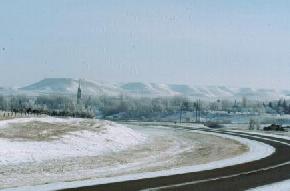
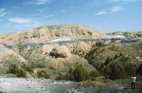
The Arikaree caprock of the Killdeer Mountains consists of tuffaceous sandstone and siltstone that is interbedded with thin layers of freshwater carbonates. Dating techniques performed a tuffaceous
layer 200 feet below the top of South Killdeer Mountain indicated that volcanic ash at that horizon was deposited approximately 25 million years ago. The presence of interbedded carbonates in the tuff
would make mining and processing of this material very difficult. The tuffaceous rocks are present throughout the 4,800 acre area of the Killdeer Mountains. (Photo by E. Murphy, NDGS).
|
|
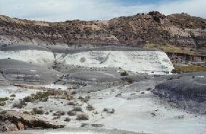
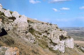
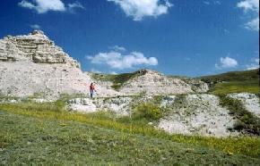
A 2-to 3 foot tuff layer (Antelope Creek Ash) is present in the lower portion of the Brule Formation in the Little Badlands southwest of Dickinson. The man is standing on the top of the Antelope Creek Ash
in this photograph taken in the Little Badlands. This tuff is very fine grained and initial attempts at dating this layer failed. The Antelope Creek Ash may extend over an area of 2000 acres. (Photo by E. Murphy, NDGS).
Selected References for North Dakota Volcanic Ash
Forsman, N.F., 1985, Petrology of the Sentinel Butte Formation (Paleocene), North Dakota: Unpublished Doctoral Thesis, University of North Dakota, 222 p.
Forsman, N.F., 1984, Durability and alteration of some Cretaceous and Paleocene pyroclastic glasses in North Dakota: Journal of Noncrystalline solids, Vol. 67, p. 449-461.
Forsman, N.F., 1992, Tuffs in North Dakota, in Proceedings of the F.D. Holland, Jr., Geological Symposium, Erickson, J.M. and Hoganson, J.W., eds: North Dakota Geological Survey Miscellaneous Series No. 76, p. 267-273.
Larsen, R.A., 1988, Major and trace element characterization and correlation of the Sentinel Butte ash/bentonite (Paleocene): M.S. Thesis, University of North Dakota, 162 p.
Manz, O.E., 1962, Investigation of pozzolanic properties of the Cretaceous volcanic ash deposit near Linton, North Dakota: North Dakota Geological Survey Report of Investigation No. 38, 42 p.
Murphy, E.C., Hoganson, J.W., and Forsman, N.F., 1993, The Chadron, Brule, and Arikaree Formations in North Dakota: North Dakota Geological Survey Report of Investigation No. 96, 144 p.
 ]
]