There are three main types of salt deposits within the Williston Basin of North Dakota: halite, potash, and Glauber salt or mirabolite. Halite (sodium chloride or table salt) and potash occur in
thick deposits in the deep subsurface in the western part of the basin. On the other hand, Glauber salt occurs at or within 70 feet of the surface throughout North Dakota.
Halite beds are found in the Prairie (Devonian), Charles (Mississippian), Opeche (Permian), Spearfish (Permian-Triassic), and Piper (Jurassic) formations. Potash beds are known to occur in the
Prairie Formation (Devonian). Sodium sulfate deposits are known to occur in Holocene lacustrine sediments.
Halite
Halite occurs in as many as 11 beds ranging in age from Devonian to Jurassic and occurring at depths of 3,600 (McHenry County) to 12,600 feet (McKenzie County) in North Dakota.
In the past, salt was produced from solution mines at a site near Williston and a site in Bowman County.
Potash
Potash may be mined from North Dakota in beds of sylvite (potassium chloride) or sylvinite (mixtures of potassium chloride and sodium chloride). Approximately 50 billion tons of potash
occur in the Prairie Formation (Devonian) in North Dakota. These evaporites were deposited in a trough that extends from the Northwest Territories in Canada to northeastern Montana and
northwestern North Dakota. Potash beds occupy an area of 11,000 square miles that extends from the Montana border to central Bottineau County and from the Canadian border to central Dunn
County. This salt interval reaches its maximum thickness of over 500 feet in Burke County. The potash portion of the salt section has a gross thickness of 83 feet.
The main reason that North Dakota's potash deposits have not been utilized is because these same beds are found at much shallower depths which enable the use of both conventional mining as well
as solution mining in southern Saskatchewan. There are currently ten potash mines in Saskatchewan. Kalium operates a large potash plant that processes brines from a series of solution wells near
Belle Plain, Saskatchewan. Potash is primarily used in the manufacture of fertilizer although testing is currently being done to determine the feasibility of a potash based water softening salt.
Sodium Sulfate (Glauber Salt)
Many of the lakes in northwestern North Dakota contain brine, water with a high salt content, throughout much of the year. Sulfate concentrations exceed 100,000 milligram per liter (mg/l) in many of these lakes.
The salt content of these lakes typically is lowest in the spring and increases throughout the year until it reaches a point in the late summer and fall when evaporation and cooling water temperatures cause Glauber
salt to be precipitated. In fact, many of these are playa lakes; that is they routinely go completely dry in the late summer and fall. It is common for 2 to 8 inches of Glauber salt to form on these lake bottoms
in the fall. Due to the high salinity of the water, most of these lakes contain little or no aquatic life, with the exception of brine shrimp.
Scientists believe that sodium sulfate crystals (in the form of mirabolite) began forming in some of the shallow lake bottoms in the northwest portion of the state shortly after the end of glaciation
approximately 12,000 years ago. Many of the lakes in this area contain layers of sodium sulfate crystals that are from a few inches to over 20 feet thick. The thickness of lacustrine sediments beneath
these lakes is quite variable from lake to lake and, at least in a few cases, quite variable within a given lake. Two lakes (Grenora #2 and Miller Lake) contain an average of 15 to 20 feet of lacustrine
sediments (including mud and salt) and also have depressions which contain 50 to 70 feet of clay and salt. These depressions are thought to have been created when large iceblocks trapped in the glacial
sediment slowing melted creating voids. As a result of the variability of thickness and of the thickness and extent of Glauber salt layers, numerous holes must be drilled at each lake in order to accurately
determine the amount of salt in a given deposit. Information obtained by a 1934 Federal Emergency Relief Administration project, a 1952 U.S. Bureau of Mines study, a recent North Dakota Geological Survey
project were used to determine that there is an estimated 46 million tons of Glauber salt beneath fifteen lakes in northwestern North Dakota.
Historically, the main use for Glauber salt has been in the production of Kraft paper. However, in recent years the detergent industry has become the main consumer of this salt in its use as a filler
for powdered laundry detergent. A Canadian company recently began converting sodium sulfate to sodium bicarbonate by adding anhydrous ammonia and carbon dioxide to the salt. A byproduct of this procedure
is ammonium sulfate, a marketable fertilizer.
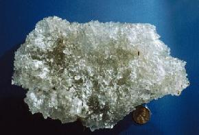
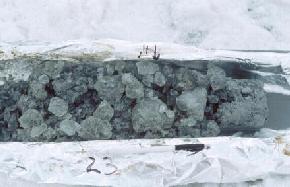
Crystals of mirabolite from salt crust at the base of North Lake, Divide County. Mirabolite (NaSO4.10H2O) is the hydrated mineral form of sodium sulfate.
Mirabolite readily converts to a dehydrated mineral form (thenardite) upon heating. The clear crystals throughout this sample are mirabolite while the white crust on the left side of
the sample are thenardite. (Photo by E. Murphy, NDGS).
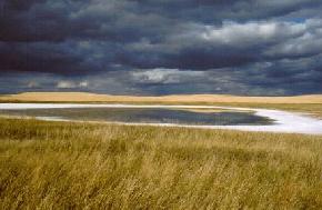
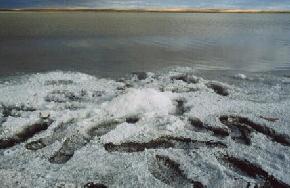
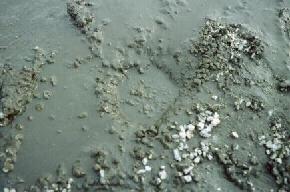
Typically, as water levels decline in the late summer and fall, a ring of salt (largely thenardite) becomes visible along the shores of many of the lakes in the
northwest portion of the state. (Photo by E. Murphy, NDGS).
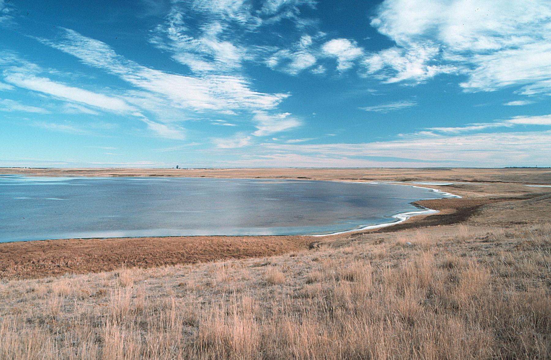
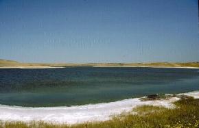
North Lake, Divide County, in late summer. (Photo by E. Murphy, NDGS).
Stanley #2, Mountrail County in late summer. (Photo by E. Murphy, NDGS).
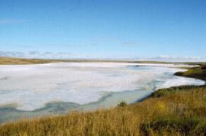
Stink Lake. Eventually, many of these lakes go completely dry in the fall. These playa lakes generally contain a foot or two of water in the spring and experience slowly declining water levels throughout the summer.
(Photo by E. Murphy, NDGS).
Miller Lake, Divide County. As temperatures drop in the fall, the cooling water can no longer hold as high of concentrations of salt and mirabolite crystals sink to the bottom of the lake.
In recent years, Miller Lake has contained from 4 to 8 inches of salt crystals i 06-Feb-2009 s back into solution when runoff enters the lake basin and water temperatures rise. (Photo by E. Murphy, NDGS).
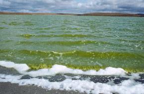
The waters of Horseshoe Lake (Williams County) have been extremely green the last few years due to high concentrations of algae. (Photo by E. Murphy, NDGS).
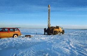
There are only a few ways to obtain sediment samples from beneath these lakes: hand augering in the late fall, drilling from a floating platform (barge) during the summer, or drilling with a truck
mounted rig in the winter when the lake has sufficiently frozen. The North Dakota Geological Survey chose to drill in the winter and had to contend with temperatures that ranged from 30 to -24 degrees Fahrenheit).
(Photo by E. Murphy, NDGS).
Mirabolite crystals obtained from a depth of 23 feet in Miller Lake, Divide County. The amount of silt, clay, and organic debris in the salt layers was extremely variable. Some portions of the salt layers
were very clean while others contained high amounts of detritus. (Photo by E. Murphy, NDGS).
Miller Lake (Divide County) is underlain by 15 to 50 feet of lacustrine sediments. These sediments include layers of Glauber salt, salt-bearing clay, and silt.
The thickest accumulation of lacustrine sediments occurs in the northeast portion of the lake. High concentrations of gas were encountered immediately beneath many of the layers of salt.
Gas bubbling from a 25-foot hole at Miller Lake, Divide County. The gas is likely a combination of methane and hydrogen sulfide. The methane is a result of breakdown of the organic-rich muds
and clays and the hydrogen sulfide from anaerobic activity. Concentrations were sufficiently high to cause several of the holes to be abandoned due to health concerns. (Photo by E. Murphy, NDGS).
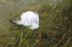
A salt encrusted Ross' goose at Stanley #2, Mountrail County. Quick drops in temperature in the fall sometimes cause high amounts of mirabolite to form
literally overnight. As a result, waterfowl such as this goose can become encrusted with salt, which can be fatal. Although this goose was nursed and fed for a few days it
was not able to recover and died. (Photo by E. Murphy, NDGS).
Selected References for North Dakota Salt
Halite
Anderson, S.B., and Hansen, D.E., 1957, Halite deposits in North Dakota: North Dakota Geological Survey Report of Investigation No. 28, p.
Fischer, D.W., and Anderson, S.B., 1984, Little-known mid-Paleozoic salts of northwestern North Dakota: North Dakota Geological Survey Report of Investigation No. 83, 18 p.
Potash
Anderson, S.B., and Swinehart, R.P., 1979, Potash salts in the Williston Basin, U.S.A.: North Dakota Geological Survey Report of Investigation No. 68, 18 p.
Carlson, C.G., and Anderson, S.B., 1966, Potash in North Dakota: North Dakota Geological Survey Miscellaneous Series No. 26, 12 p.
Glauber Salt
Burr, A.C., McMillan, W.W., and Budge, C.E., 1951, Sodium sulfate, North Dakota resources, nature-development-utilization: North Dakota Research Foundation, 115 p.
Grossman, I.G., 1949, The sodium sulfate deposits of western North Dakota, a progress report: North Dakota Geological Survey Report of Investigation no. 1, 66 p. Lavine, Irvin,
Report of sodium sulfate investigation--Report to the Federal Emergency Relief Administration, Project no. S-F2-48: University of North Dakota, 38 p. Lavine, Irvin, and Feinstein,
Herman, 1935, Natural deposits of sodium sulfate in North Dakota: University of North Dakota School of Mines, 8 p. Murphy, E.C., 1996, The sodium sulfate deposits of northwestern
North Dakota: North Dakota Geological Survey Report of Investigation no. 99, 78 p.
Witkind, I.J., 1952, The localization of sodium sulfate deposits in northeastern Montana and northwestern North Dakota: American Journal of Science, v. 250, p. 667-676.
 ]
]