[ ]
]
[]

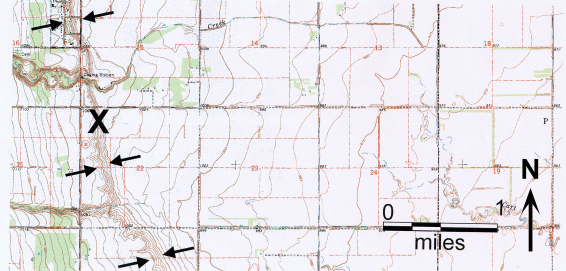
The second X Marks the Spot contest drew widespread interest and responses from our readers. Responses were submitted by 30 individuals.
Twenty-six individuals correctly identified the nearest town site as Mountain, North Dakota, which Prof. Bill Locke of Montana State University points out must be an oxymoron.
Anyone living in the shadows of real mountains would naturally concur.
Unfortunately, less than one half of the respondents correctly identified the landform as a beach ridge, wave-cut lake scarp, or strand line.
The majority erroneously identified the scarp as the Pembina Escarpment. Even some knowledgeable geologists in the state were stumped, including Prof.
Donald Schwert from NDSU, who was so confident of his answer that he responded: "X is the Pembina Escarpment at Mountain.
Now please send an official NDGS embossed leather jacket, size large, tall, to my address below." That comment was worth a day full of chuckles for more than one reason.
The town name, Mountain, most likely is a reference to the Pembina Escarpment, which has over 150 feet of relief and is visible to the west of the town.
The Pembina Escarpment (a.k.a. Manitoba Escarpment across the border) began to form about three to four million years ago from groundwater sapping in the embryonic Red River Valley (Bluemle, 2000, p. 50).
The X marks parts of the Campbell-McCauleyville shoreline. In contrast to the Pembina Escarpment, the Campbell scarp has only 40 to 50 feet of relief, is located east of Mountain, and formed at the end of the last Ice Age,
approximately 12,000 to 9,000 years ago. The Campbell beach is the most continuous and generally best developed beach of glacial Lake Agassiz; it is named for the town of Campbell, Minnesota (Bluemle, 2000, p. 72).
The Campbell beach represents the elevation of glacial Lake Agassiz from approximately 12,200 to 11,000 years before present, around 10,700 years before present, and again from approximately 9900 to 9000 years before present (Arndt, 1977).
Prior to 12,200 years before present, the lake stage was above the Campbell beach and glacial Lake Agassiz drained through a southern outlet into the Minnesota River valley. The Campbell beach is below the elevation of the southern outlet.
The lake drained temporarily from about 11,000 to 10,700 years before present and again from 10,500 to 9900 years before present when an ice-dammed eastern outlet to Lake Superior was opened (Arndt, 1977).
This eastern outlet was periodically blocked by ice causing glacial Lake Agassiz to refill to the Campbell stage a few times in the early Holocene.
Numerous other shorelines of glacial Lake Agassiz have been identified in the Red River Valley. In northeastern North Dakota, these include the Herman, Norcross, Tintah, Campbell-McCauleyville, Blanchard, Hillsboro,
Emerado, Ojata, Gladstone, Burnside, Ossowa, and Stonewall beaches (from highest to lowest). Some of the more prominent shorelines can be traced to southern North Dakota and eastward into western Minnesota.
Prevailing westerly winds caused wave action to be stronger on the eastern shore of glacial Lake Agassiz in Minnesota, where the beaches are generally better developed than along the western shore.
Many respondents commented on the Icelandic origins of Mountain and its annual celebration, August the Deuce. Fiedler remarked, "I am formerly of Cavalier, North Dakota (living in economic exile in Colorado).
Growing up, my mother always implored me not to go to Mountain for 'August the Deuce' as it was known as a wild celebration."
As with the first contest, a large percentage (33%) of respondents are residents of other states. Some of these, such as Ramsey, grew up minutes from Mountain and were quick to supply the correct answers.
Hobbs supplied a quick answer too, as he studied the beaches while a graduate student at UND and married a woman from the Mountain area, giving him reasons to return frequently for August the Deuce and family gatherings.
Ramsey, Black, and Gardner have the distinction of submitting correct responses in both contests to date.
Linda Hagen, our Office Assistant, conducted the drawing for disbursement of our prizes. Kevin Swanson was selected to receive a copy of The Face of North Dakota, and Jerry Saude received the Geologic Map of North Dakota. Thanks to all for participating.
| Tony Alkofer - Park River | Bruce Ramsey - Vienna, VA |
| Ken Gardner - Drayton | Gary Stefanovsky - Bismarck |
| Howard Hobbs - St.Paul, MN | Kevin Swanson - Shoreview, MN |
| William Locke - Bozeman, MT | Barrett Williams - Tucker, GA |
| Stan Pence - Vermillion, SD |
| Pat Brenden - Dunseith | Blair Meier - Hazen |
| Erling Brostuen - Golden, CO | George Ott - Dickinson |
| Steve Fiedler - Aurora, CO | Chris Padilla - Menoken |
| Mike Knudson - Bismarck | Gina Padilla - Bismarck |
| Bennett Kubischta - Bismarck | Kevin Preston - Denver, CO |
| Bill Lardy - Bismarck | Dennis Roden - Fargo |
| Marc Kurz - Grand Forks | Donald Schwert - Fargo |
| James Lindbeck - St. Paul, MN | Wes Peck - Grand Forks |
| Joe Martinetti - Bismarck | Dwain Zodrow - Minot |
| Paul Meisel - Sawyer |