[ ]
]
[]

|
[For this Note, I adapted much of the content of an article by Lee Clayton: Bison trails and their geologic significance, Geology, September, 1975 JPB] An unusual kind of landform found in several places in North Dakota was created by once huge herds of bison. The bison trampled shallow grooves across the prairie, forming trails that appear as lines on air photos. These "bison trails" were first recognized in North Dakota in the 1960s by former University of North Dakota geologist, Lee Clayton. The trails are shallow grooves or trenches, generally a few feet deep, several feet wide, and several hundred feet long. Where they cross narrow depressions, the trails sometimes change to low ridges. The ridges probably formed as sediment was tracked downslope by thousands of hooves. Bison trails are common throughout the grasslands of the northern plains, and, in fact, many have been misinterpreted as bedrock joints or glacial features. Bison trails are straight or gently curved, and they show up on aerial photographs as dark lines. The trails tend to be parallel to high-relief features such as bluffs and steep slopes, and otherwise they typically trend northwest to southeast, parallel to the prevailing wind directions. The trails were probably formed when large numbers of bison converged on water holes or were funneled along a particular path by the constraints of topography. The trails are best preserved where they cross areas of sandy soil, such as gravel outwash plains, perhaps because such soils are more permeable, allowing precipitation to infiltrate the soil rather than run off, eroding the slope and trails. Even so, I have seen similar trails that cross areas of glacial till. |
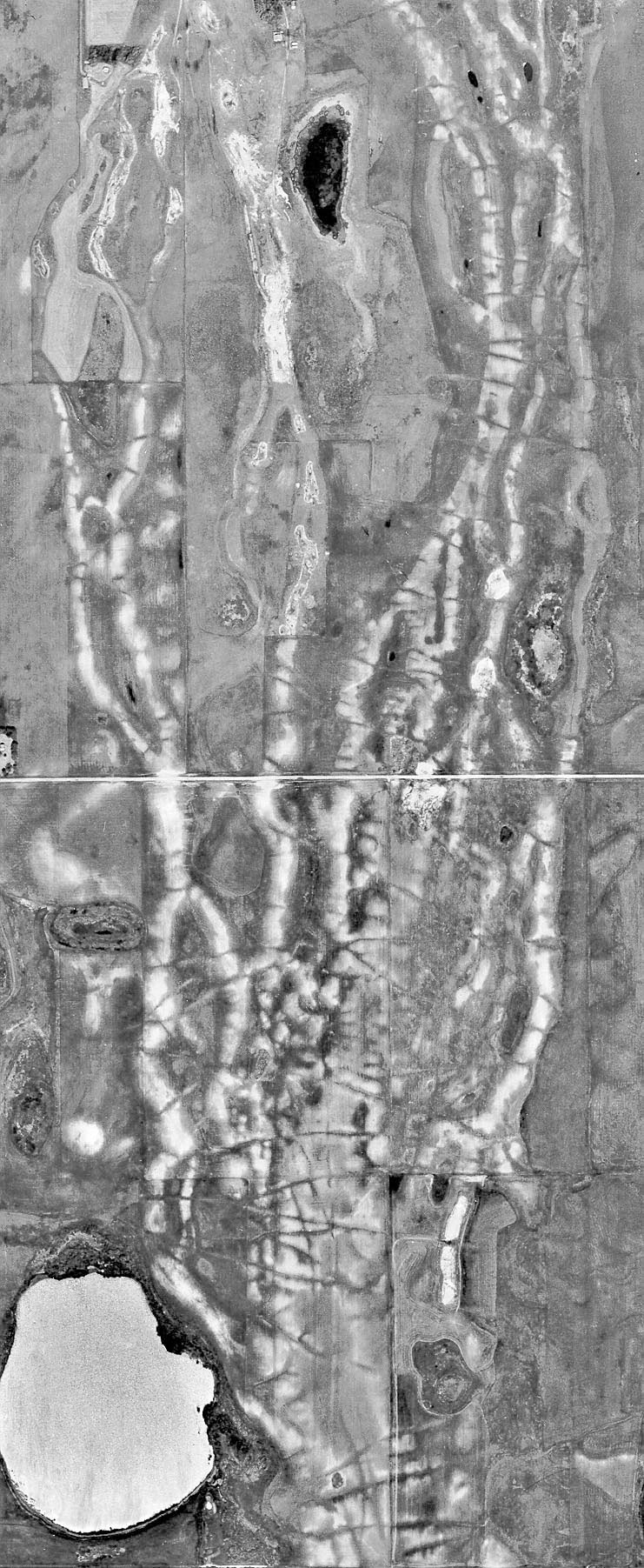 Bison Trails in the Denbigh Bog area in the old channel of the Souris River, about eight miles southeast of Denbigh in McHenry County. The arrow points to the bison trails along the eastern edge of the bog area. The trails oriented mainly north-south, apparently a result of bison tending to walk around the edge of the bog. (Click to enlarge) 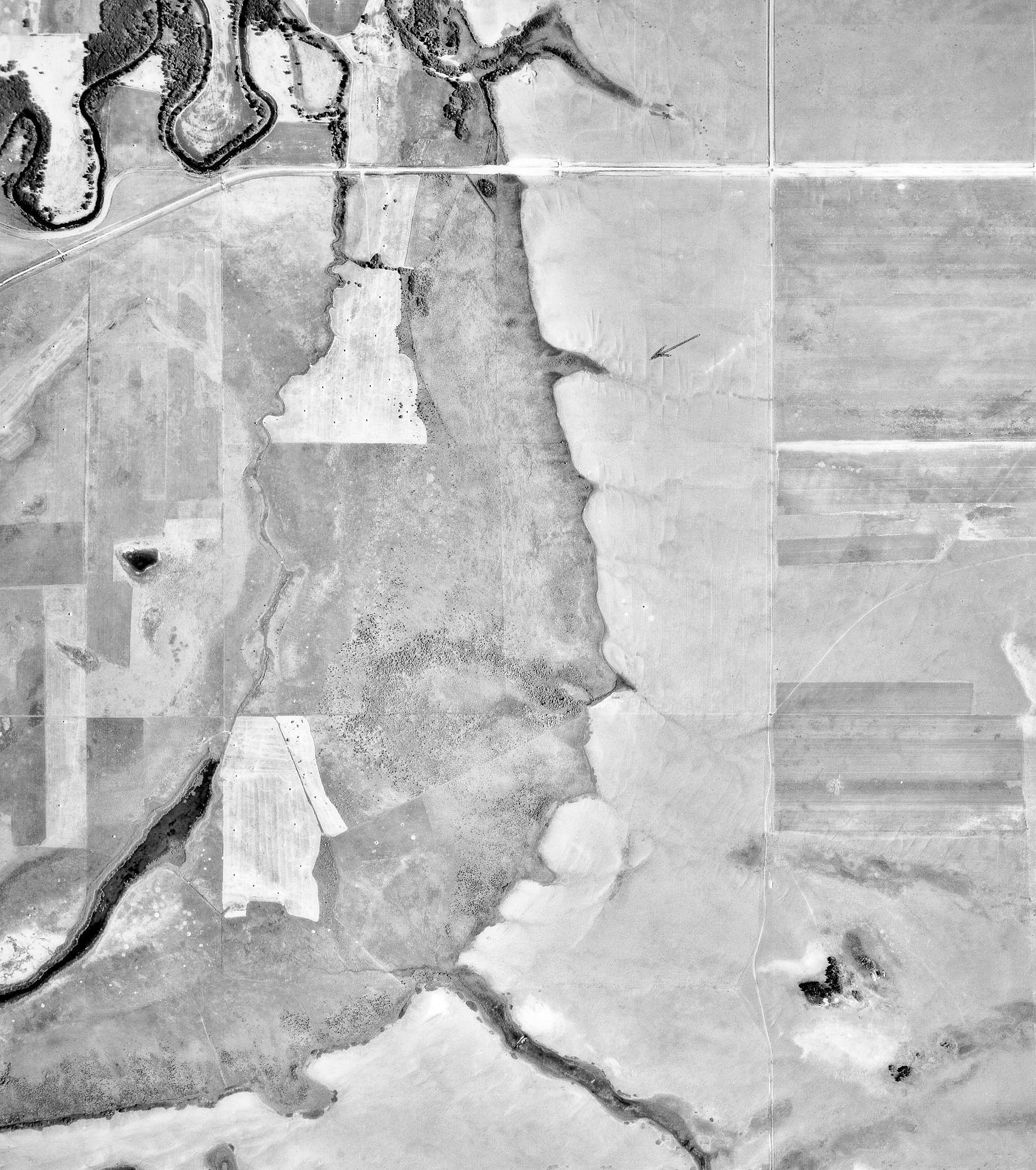 Bison Trails in the Denbigh Bog area in the old channel of the Souris River, about eight miles southeast of Denbigh in McHenry County. The arrow points to the bison trails along the eastern edge of the bog area. The trails oriented mainly north-south, apparently a result of bison tending to walk around the edge of the bog. (Click to enlarge) |
|
In areas of low relief, as in parts
of the Red River Valley, the grooves tend to lie parallel to the prevailing
wind directions, which throughout much of North Dakota was from the northwest
(in winter) and southeast (in summer). In areas of medium to high relief,
the orientation of the grooves is controlled by the local topography the
grooves tend to cross medium-relief features such as eskers, beach ridges
and small valleys. The grooves tend to be parallel to higher relief bluffs
and steep slopes. The features appear to be restricted to grassland areas of the interior of North America. They occur throughout North Dakota, to the forest edge in western Minnesota, in much of eastern Montana and Wyoming, in most of South Dakota, and in southern Manitoba, Saskatchewan, and Alberta. The trench-like features had earlier been interpreted as representing bedrock joints and faults. They have also been interpreted as glacial disintegration trenches a kind of long, narrow depression resulting from the melting of an ice-cored crevasse filling. The ridged portions of the features have been interpreted as having formed when an ice-cored crevasse fill transected an ice-cored esker. The disintegration-trench hypothesis became untenable, however, when the trenches were found in southwestern North Dakota, beyond the limit of glaciation. Furthermore, the ridged portion of the features consists of thick topsoil, not fluvial sand and gravel as would be required were they disintegration trenches. A bison-trail origin seems to best explain the features. 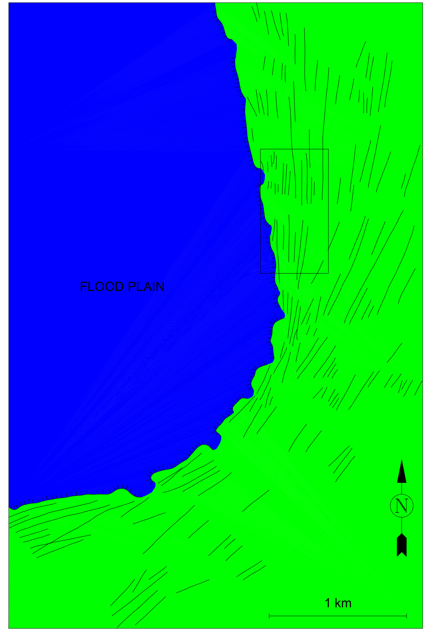 Bison trails around a southeast bend of Souris River flood plain in secs. 25 and 36. T. 155 N., R. 77 W., McHenry County, North Dakota. Hachured line marks the bluff at edge of flood plain. (Click to enlarge) |
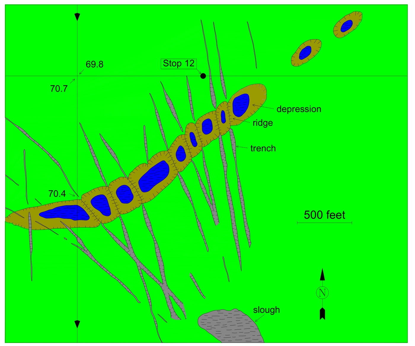
Bison trails changing from trenches to ridges where trails cross a shallow depression in a pitted proglacial fluvial plain in northwest corner of sec. 35. T. 140 N., R. 71 W., Kidder County. North Dakota. From Clayton and Freers (1957. Fig. R-21), who mistakenly called them disintegration trenches. (Click to enlarge) |
|
Observation of cattle trails on steep slopes
has suggested an explanation for the ridged portion of the features. Clumps
of dirt are kicked along the trail by the walking cattle, and globs of
mud stick to their hooves. On a sloping trail, the clumps tend to be worked
downhill. This results in transport of material down the path and produces
a ridge at the base of the slope in continuity with the trench. Did bison actually make the trails? Many nineteenth-century travelers commented on the abundance of bison trails on the Great Plains. In 1846, Francis Parkman noted bison trails near the Platte River, as did General J. F. Rusling. According to Alexander Henry the Younger, bison trails were abundant in northeastern North Dakota. Why should bison trails be restricted to highly permeable soil? On slightly permeable soil, most of the precipitation runs off, eroding the hillslopes and destroying trails. On highly permeable soil, most of the precipitation infiltrates, resulting in only slight slope-wash erosion. For this reason, bison trails have been preserved mainly in areas of permeable, coarse soil. 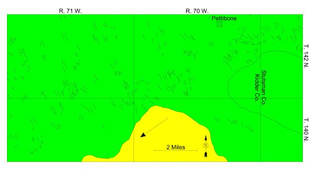 Orientation of bison trails on a pitted proglacial fluvial plain in Kidder County, North Dakota. From Clayton (1967, Fig. a-6). who mistakenly called them disintegration trenches formed from glacial crevasses; large arrow shows ice-movement direction, indicating that pattern is appropriate for glacial crevasses in area of extending flow (Clayton, 1967, p. 39). |
|
Where were the bison going? Why do the trails tend to be
orientednorthwest-southeast, parallel to prevailing wind? Perhaps they
were watering trails (trails made by range cattle generally lead to water).
The bison may have located water by the downwind odor of water or vegetation
growing next to the water. Or, perhaps, the reaction of the bison to the
wind itself, rather than the odor, was the cause. Perhaps seasonal migration
routes controlled their direction. Bison trails are of interest to geologists for two reasons: (1) they may be confused with geologic features, and (2) they may have influenced drainage patterns. Bison trails can be distinguished from joints and faults in that ridges tend to represent trails where they cross depressions. Trails can be distinguished from normal stream-eroded gullies by the tendency of trails to cross over hills and through depressions. Small stream valleys throughout much of the Great Plains are aligned parallel to the prevailing wind direction. A possible reason is the initiation of gullies by wind or bison trails. Small gullies are commonly initiated where runoff water (and wind erosion) has been concentrated in cattle trails, so it seems probable that a pattern of bison trails like that would result in gullies and small valleys oriented parallel to the prevailing wind. Obviously, many trails in North Dakota have been enlarged by gullying. However, the magnitude of this influence is difficult to evaluate because bison trails are preserved mainly in areas of permeable soils where erosion has been slight. In areas of less-permeable soils, where gullying has been extensive, all trace of bison trails has presumably been eroded away during the past century (since the demise of the bison). References: Beaty, C. B., 1975, Coulee alignment and the wind in southern Alberta, Canada: Geological Society of American Bulletin, v. 86, p. 119 - 128. Bluemle, J. P., 2000, The face of North Dakota, Third Edition: North Dakota Geological Survey Educational Series 26, 205 p. Branch, E. D., 1962, The hunting of the buffalo: Lincoln, University of Nebraska Press, 240 p. Clayton, Lee, 1970a, Olfactory factors in landscape evolution: North Dakota Academy of Science Proceedings, v. 24, p. 4 Clayton, Lee, 1970b, Bison trails and their geologic significance: Geological Society of America Abstracts with Programs, v. 2, p. 381. Clayton, Lee, 1975, Bison trails and their geologic significance: Geology, p. 498 - 500. Coues, Elliott, ed., 1965, The manuscript journals of Alexander Henry...: Minneapolis, Ross and Haines, 1027 p. Mollard, J. D., 1957, Aerial mosaics reveal fracture patters on surface materials in southern Saskatchewan and Manitoba: Oil in Canada, August 5, p. 26 - 48. Zakrzewska, Barbara, 1965, Valley grooves in northwestern Kansas: Great Plains Journal, v. 5, no. 1, p. 12 - 25. |