Three-fourths of North Dakota is covered by glacial sediments. These glacial deposits contain sand and gravel as either outwash or as isolated lenses of sand and gravel within till. Beach ridges
and deltas that formed along glacial lakes Agassiz and Souris are also important sources of sand and gravel. Pliocene to Holocene age sand and gravel deposits also occur as terrace deposits, and less
commonly as pediments, in the western part of the state. Sand and gravel is the third largest mineral industry after oil and gas and lignite.
Grain size and the quality of sand and gravel are limiting factors which determine whether or not a sand and gravel deposit is developed. The quality of the gravel can be highly variable within a given
deposit. The various uses of sand and gravel, such as fill drainage, well screen, concrete, etc., have variable tolerances for the quality of sand and gravel. Usually the percentage of shale in sand and
gravel is the limiting factor for its usefulness. This is especially true for concrete where shale pebbles tend to "pop out" or be "plucked" by the actions of freeze-thaw. In addition, both volcanic and carbonate
pebbles may chemically react with the pavement causing zones of weakness, etc. Transportation of sand and gravel is expensive and often makes up the major share of the cost per ton. In areas where good quality sand
and gravel is not available, it may be more economical, for some purposes, to crush rocks (sandstones) in the area.
Clinker, commonly referred to as scoria, consists of clay, silt, and sandstone baked or fused by the heat generated from the burning of underlying lignite. Due to the scarcity of gravel in southwestern
North Dakota, clinker is commonly used as road metal.
Sand and gravel deposits in North Dakota
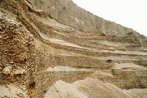
Twenty feet of glaciofluvial sand and gravel is present beneath six feet of till at a pit in Williams County. Lenses of well sorted sand are present between layers of moderate to coarse gravel.
(Photo by E. Murphy, NDGS).
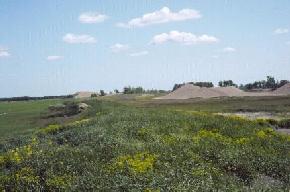
A sand and gravel pit in a spit deposit in Traill County. The beach deposits along the western edge of glacial Lake Agassiz are a source of sand and gravel in eastern North Dakota.
(Photo by D.P. Schwert, NDSU).
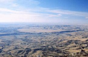
A large terrace is present above the Little Missouri River just east of Bullion Butte in Billings County. The terrace is present near the center of this oblique aerial photograph and is surrounded by
badland topography. The sand and gravel capped terrace stands approximately 200 feet above the Little Missouri River and occupies and area of about 3 square miles.
(Photo by E. Murphy, NDGS).
Several white piles of crushed carbonate rock stand along the southern end of North Killdeer Mountain, Dunn County. The carbonate and siltstone was obtained from the adjacent caprock.
(Photo by E. Murphy, NDGS).
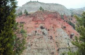
Clinker, the reddish-orange caprock of the hill in the foreground is often mined for use as road metal and decorative stone in the southwestern part of the state.
(Photo by E. Murphy, NDGS).
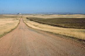
A clinker-covered road leading east to Lone Butte in McKenzie County. The Killdeer Mountains are visible on the horizon.
(Photo by E. Murphy, NDGS).
Selected References for North Dakota Sand and Gravel
North Dakota County Bulletins No. 36-80, Parts 1-3: North Dakota Geological Survey.
Moran, S.R., 1973, Sand and gravel; in Mineral and water resources of North Dakota: North Dakota Geological Survey Bulletin 63, p. 119-122.
 ]
]