The clays of North Dakota can be grouped into three general categories: bedrock clays, glacial clays, and lacustrine clays. Since three fourths of North Dakota is covered by glacial sediments,
glacial clays are the most abundant at or near the surface. But the glacial clays have not been utilized very much over the years except for the early part of the twenty century when they were used in the
manufacture of brick. It is the bedrock clays, especially the kaolinitic-rich clays in the Golden Valley Formation that have proven to be the most useful.
North Dakota clays have been used for a variety of purposes including brick making, pottery, sewer pipe, drain tile, lightweight aggregate, soaps and cleansers, kitty litter, floor adsorption material,
and as a source of alumina. Geologists over the years have also investigated clay deposits for their potential as bleaching clays, to produce electrical insulators, re-refining used lubrication oils, and as cement rock.
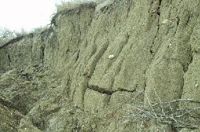
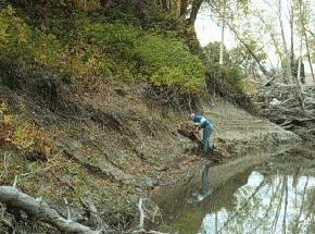
Till, glacially derived sediment consisting of a mixture of sand, silt, clay, and cobbles or boulders, is present at the surface of approximately 60 per cent of North Dakota. This photograph was taken just east of
the Williston water treatment plant. A few brick plants utilized till to produce their bricks in the early 1900's, but till can be extremely variable and is often not a reliable source of clay for most manufacturing purposes.
(Photo by E. Murphy, NDGS).
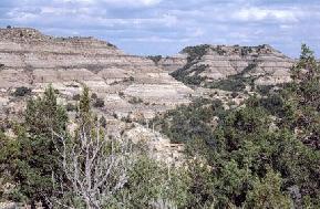
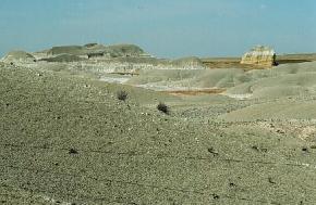
The Fort Union strata, pictured here in northern Billings County, consist of alternating beds of sand, silt, clay, and lignite. Over the years, clays in this group have been utilized in
the manufacture of bricks, light-weight aggregate, pottery, sewer pipe, and cleansers. (Photo by E. Murphy, NDGS).
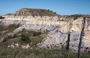
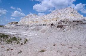
The kaolinite rich clays of the Bear Den Member of the Golden Valley Formation, pictured here in southern Dunn County, have been utilized for brick making since 1904. The bright
colors (often shades of purple, yellow, white, and orange) of the Bear Den Member make it easy to recognize to distinguish in the field from the surrounding somber brown and grey colored rocks. (Photo by E. Murphy, NDGS).
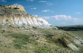
Throughout much of Dunn and Stark counties the 20 to 30 foot thick Bear Den Member is predominantly white in color. This white color can be seen here in this
outcrop north of Grassy Butte in McKenzie County. (Photo by E. Murphy, NDGS).
The Rhame Bed, shown here near Deep Creek in northern Slope County, is another brightly colored kaolinitic bed. The 20 to 30 foot thick Rhame bed is present approximately 1200 feet below the Bear Den Member.
Both the Rhame Bed and the Bear Den Member are thought to have resulted from extended or intense periods of weathering. (Photo by E. Murphy, NDGS).
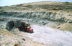
This is one of the clay pits for the Hebron Brick Company in northwestern Morton County. The bricks are produced from a mixture of white and gray clay from the Bear Den Member,
sandstone from the overlying Camels Butte Member, and recycled bricks. The Hebron Brick Company presently mines approximately 40,000 tons of clay per year to produce 20 million bricks. (Photo by E. Murphy, NDGS).
A 30 foot thick layer of swelling clay in the South Heart Member of the Chadron Formation in the Little Badlands south of South Heart, Stark County. This, and other beds of swelling clay in North Dakota,
have often been referred to as bentonites. The South Heart Member was mined in the early 1930s and marketed as Dakonite Soap by the Dakota Colloidal Products Company. (Photo by E. Murphy, NDGS).
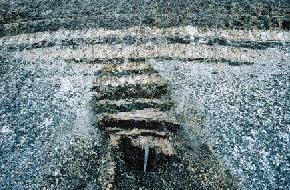
A fuller's earth deposit is exposed near the base of the Pierre Formation in the Pembina River Valley northwest of Walhalla in Cavalier County. Fuller's earth is a fine earthy material that has the
ability to bleach or absorb coloring matter from oils and fats. This deposit was discovered in the 1930s and was found to extend over portions of eastern Cavalier and western Pembina counties. The deposit
consists of a 4 to 8 foot bed of interbedded yellow bleaching clay and gray nonbleaching clay. This deposit was determined to contain a bleaching value of 35 to 40%. (Photo by E. Murphy, NDGS).
Outcrop of the Sherack Formation (Pleistocene) along the Red River Valley in north Fargo, Cass County. Recent studies on the Minnesota side of the Red River Valley indicate that bloating clays in
the Sherack and underlying Brenna Formation are suitable for lightweight aggregate. (Photo by D.P. Schwert, NDSU).
Selected References for North Dakota Cement Rock
Babcock, E.J., 1906, The uses and value of North Dakota clays, in the Fourth Biennial Report of the North Dakota Geological Survey, p. 191-244.
Budge, W.E., 1932, Report of surface of Tertiary clays in southwestern North Dakota: University of North Dakota College of Engineering and Mines and Mining Experiments, p. 21-38.
Budge, W.E., 1936, The bentonites of North Dakota: University of North Dakota School of Mines, 17 p.
Clapp, C.H. and Babcock, E.J., 1906, Clay and its properties with special reference to North Dakota clays, in the Fourth Biennial Report of the North Dakota Geological Survey, p. 9-62.
Clapp, C.H. and Babcock, E.J., 1906, Economic geology of North Dakota clays, in the Fourth Biennial Report of the North Dakota Geological Survey, p. 95-190.
Clark, F.F., 1948, Southwestern North Dakota clay deposits Stark, Slope, and Billings counties, North Dakota: United States Bureau of Mines Report of Investigations No. 4219, 32 p.
Hansen, Miller, 1959, Clays of North Dakota as a potential source of alumina: North Dakota Geological Survey Report of Investigation No. 33, 15 p.
Manz, O.E., 1953, Investigation of some North Dakota clays and shales: North Dakota Geological Survey Report of Investigation No. 13, 36 p.
Manz, O.E., 1954, Investigation of lightweight aggregate possibilities of some North Dakota clays and shales: North Dakota Geological Survey Report of Investigation No. 17, 48 p.
Manz, O.E., 1956, Investigation of Lake Agassiz clay deposits: North Dakota Geological Survey Report of Investigation No. 27, 34 p.
Manz, O.E., 1973, Clay and lightweight aggregate in Mineral and Water Resources of North Dakota: North Dakota Geological Survey Bulletin 63, p. 122-129.
Murphy, E.C., 1995, North Dakota clays, a historical review of clay utilization in North Dakota: North Dakota Geological Survey Miscellaneous Series No. 79, 18 p.
Clay Maps
 ]
]