Several attempts have been made in North Dakota, starting in the early 1890s, to produce natural cement. From 1899 to 1909, a natural cement plant operated west of the town of Concrete
in eastern Cavalier County. The plant baked high lime shales from the Niobrara Formation in kilns and ground and packaged the resulting natural cement. This natural cement had a hard time
competing with the superior grades of portland cement and the plant closed.
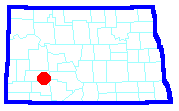
The rocks in several other areas in both western and eastern North Dakota have been investigated for their potential use in making natural cement. Ten carbonate-capped buttes in eastern Stark and
Hettinger counties were studied to determine their suitability in the manufacturing of natural cement. In northeastern North Dakota, "high lime zones" within the Niobrara Formation in Walsh and Grand
Forks counties were investigated, as were Paleozoic carbonates at depths of a few hundred feet below the Red River Valley.
Other than the short lived plant at Concrete, the carbonates in North Dakota have not been utilized in the manufacturing of natural cement.
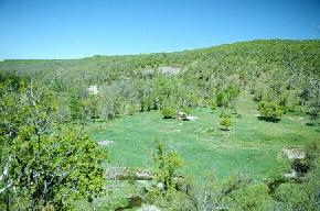
The clearing in the foreground is the site of the old Portland Cement Company plant near Concrete in eastern Cavalier County. Shales from the Niobrara and Pierre formations are exposed along the
hillside in the background. The remains of the kilns used to bake the high lime shales are present near the center of the photograph. (Photo by E. Murphy, NDGS).
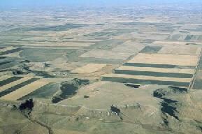
Aerial photograph of White Butte in northern Hettinger County. White Butte is typical of the twenty or so flat-topped, white rimmed buttes in this area. These buttes are capped by 1 to 10
foot thick beds of freshwater carbonates that occur in the South Heart Member of the Chadron Formation. (Photo by E. Murphy, NDGS).
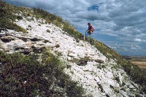
The freshwater carbonate caprock of South Lime Hills in southeastern Stark County. The carbonate caprock in this area was investigated in the 1940s and 50s for utilization
in the production of natural cement. (Photo by E. Murphy, NDGS).
Selected References for North Dakota Cement Rock
Anderson, S.B. and Haraldson, H.C., 1968, Cement-rock possibilities in Paleozoic rocks: North Dakota Geological Survey Report of Investigation No. 48, 62 p.
Carlson, C.G., The Niobrara Formation of eastern North Dakota: its possibilities for use as a cement rock: North Dakota Geological Survey Report of Investigation No. 41, 56 p.
Hansen, Miller, 1953, Geologic report on limestone deposits in Stark County and Hettinger County, North Dakota: North Dakota Geological Survey Report of Investigation No. 8, 33 p.
Murphy, E.C., Hoganson, J.W., and Forsman, N.F., 1993, The Chadron, Brule, and Arikaree Formations in North Dakota: North Dakota Geological Survey Report of Investigation No. 96, 144 p.
 ]
]