[ ]
]
[]

Ten out of sixteen respondents correctly identified the features in competition #15 as bison trails but the reasons why they are of interest to geologists stymied all but four. The answers are:
1.Bison trails may be (and have been) confused with geologic features such as joints, faults and glacial disintegration trenches
2.They may have influenced the modern drainage pattern of the Great Plains
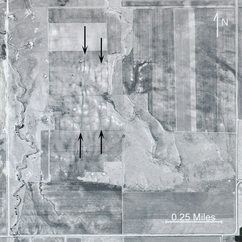
The bison trails shown in the aerial photograph for competition #15 (fig. 1) are a few miles northwest of Stanton in Mercer County. At a little under half a mile in length they represent a mere fragment of
the vast network of intersecting trenches and ridges created by the movements of the great bison herds that once roamed the grasslands of the Great Plains. Previously interpreted as joints and faults
(e.g. Mollard, 1957; Zakrzewska, 1965; Erickson, 1970) and glacial disintegration structures (Clayton, 1962; Clayton and Freers, 1967), the trenches were first identified as bison trails by geologist
Lee Clayton in 1975. This new hypothesis explained several things about these features that the earlier interpretations could not, such as why they form ridges where they cross depressions and why they tend
to be restricted to areas of permeable soil. It also accounts for their occurrence in southwestern North Dakota, far beyond the limit of glaciation. Why ridges and why only permeable soil? You are encouraged
to read Clayton’s article to find out.
Another noteworthy aspect of bison trails is their orientation relative to the landscape. Except in areas of medium- to high-relief, where they generally cut perpendicularly across minor (to bison, at least)
obstacles such as eskers and small valleys, or run parallel to high bluffs, steep slopes, and other topographic constraints, the trails are aligned parallel to the direction of the prevailing wind, which in
North Dakota means northwest to southeast. Many small streams throughout the state are oriented the same way and may owe their origin to bison trails. Surface runoff commonly accumulates in cattle trails,
leading to further erosion and the eventual formation of gullies and small valleys and it’s likely that the same may be said about bison trails.
But why the northwest-southeast orientation? It is something that remains open to conjecture and readers were invited to share their own thoughts on the subject.
Clayton suggested that they were watering trails, as did several of the competition respondents. Modern cattle trails usually lead to water and by facing into the wind the bison would have located it by smell.
In his autobiography Buffalo for the Broken Heart (2001) author and rancher Dan O’Brien wrote, “Cattle may be fine for fertile farms that have been tamed for centuries, but on the Great Plains they always seem
slightly lost, and clumsy, like someone picking their way through a pasture wearing stiletto heels.” In other words, unlike their native relatives, cows are generally more accustomed to a gentler lifestyle, and whereas
they will seek shelter from bad weather bison are quite happy to stare a blizzard in the face or lie down on an exposed hilltop and gaze into the full fury of a northwesterly gale as if relishing it. It is another
possible explanation for why so many bison trails parallel the direction of the prevailing wind, and it segues nicely to the subject of migration.
Since bison clearly are not bothered by high winds, and presumably they blew across North Dakota just as strongly in the past as they do today, did the prevailing wind direction influence
their migratory routes in any way as several readers suggested? It’s quite possible because it makes sense from a practical standpoint. Walking into the wind would have done more than just
lead the animals to food and water. They would have been able to catch the scent of predators or other possible danger ahead and a good, stiff breeze in their faces might also have provided
relief from the swarms of flies and mosquitoes that no doubt plagued them in the summer months. And despite their indifference, what possible advantage would a bison gain by positioning itself
broadside to near hurricane-force winds? Keeping a low profile would surely have made travel more comfortable.
A 180° about-face would have been equally effective during the bug-free season as the bison migrated southeastwards to find grazing. Moreover, like many migratory species, they were probably creatures of habit and
followed the same route to and from their seasonal destinations.
One last thought, which should offer at least some consolation to anyone who mistook the bison trails for something of glacial origin. Figure 2 shows the orientation of a number of bison trails on a pitted
proglacial fluvial plain in eastern Kidder County. They were originally mistaken for disintegration trenches formed by the melting of ice-cored crevasse fill (Clayton, 1967). The arrow indicates the direction
of ice movement, which is roughly perpendicular to the lineate pattern – a characteristic configuration of transverse crevasses – so the misinterpretation is understandable. But even though these features are now
formally recognized as bison trails, is it just coincidental that they parallel the ice-front, or was the retreating glacier another influence on the migratory habits of these ice-age survivors?
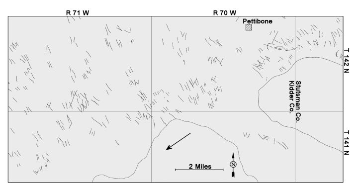
Figure 2. These bison trails in Kidder County were originally thought to be glacial disintegration trenches. Their orientation perpendicular to the direction of ice flow (large arrow)
led to this erroneous conclusion (Clayton, 1962, 1967).
Administrative Assistant Donna Bauer drew Adrian Benz and Terry Jorgenson from the remainder as the competition winners. Both will receive a copy of Dinosaurs, Sharks, and Woolly Mammoths.
Congratulations to the winners, honorable mentions to the other eight listed below whose comments are included in the narrative that follows, and thanks to everyone who participated in the competition.
| Adrian Benz - Hazelton | Gary Brekke - Fargo |
| Michael Gunderson - Ten Mile, TN | Terry Jorgenson - Eden Prairie, MN |
| Bill Kirk - Beulah | Kevin Kopplin - Grand Forks |
| John Mrozla - Harwood | Ramsey Family* - Crystal |
| Jon Reiten - Billings, MT | Gary Stefanovsky - Bismarck |
| *Ramsey family submitted one response as part of a collective effort. | |