 |
Ed Murphy North Dakota Geological Survey 600 East Boulevard Avenue Bismarck, N.D. 58505-0840 U.S.A. |
Western North Dakota contains an estimated
351 billion tons of lignite, the single largest deposit of lignite known
in the world. North Dakota also contains an estimated 25 billion tons of
economically mineable coal, enough to last for over 800 years at the present
rate of 32 million tons per year. The recorded history of lignite mining
goes back to 1873 when small mines sprung up along the main routes of transportation
in western North Dakota. At least 73 mines were operating in the state by
1900. Many of these were small, seasonal mines that removed coal from the
face of the outcrop. They were called wagon mines because area farmers and
ranchers would often bring their own wagons to the site to be filled with
coal. Still, other mines were large operations employing hundreds of men
with underground workings extending for thousands of feet. |
|
 |
 |
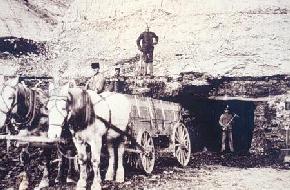
| This photograph of the Bob Miller mine near Williston was taken in 1902 or 1903. (Photo courtesy of the State Historical Society of North Dakota). | |
By the early 1920s,
there were approximately 250 mines operating in the state, with an equal
number of underground and surface strip mines. The advent of the steam shovel
increased the profitability of the surface mines and the last underground
mine ceased operation in 1966. Underground mines have caused problems in
many areas where the collapse of the mine tunnels have created sinkholes
at the surface. The North Dakota Public Service Commission has spent a considerable
amount of time and money attempting to rectify this sinkhole problem by
digging out the old mine workings where they are close to the surface and
by pumping grout into the deeper workings in an attempt to stabilize them.
A portion of the current severance tax on coal goes to a fund to support
the reclamation of these old mines. In several areas of the state (Dickinson,
Minot, and Beulah), these underground workings are present beneath highways
or county roads and have been grouted in order to stabilize the road. It
is interesting to note that as early as the 1920s, geologists for the North
Dakota Geological Survey were noting collapse features of underground mines
and warning that these underground workings were going to be posing an increasing
problem for the future. |
|
 |
 |
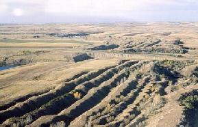
Aerial photograph
of spoils northeast of Beulah. Prior to 1969, the state of North Dakota
did not require reclamation of surface mines. As a result, approximately
6500 acres of spoil piles and surface cuts dot the countryside of western
North Dakota. (Photo by E. Murphy, NDGS). |
|
 |
 |
The amount
of vegetation on the spoil surfaces varies considerably from mine to mine
and often within a given mine. It is more difficult for vegetation to establish
itself on spoils that consist largely of clayey till or claystone. The steep,
long slopes of spoils that were created in the 1960s with the large draglines
are also commonly only sparsely vegetated. (Photo by E. Murphy,
NDGS). |
|
 |
 |
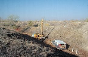
The North Dakota
Geological Survey obtaining sediment cores from spoils in the Noonan mine.
The spoils in this part of the mine were created in the mid-to late 1940s.
There has been some interest expressed in leveling the old spoil piles that
occur throughout western North Dakota, especially some of the larger mines.
A study of the groundwater conditions and the natural salts within the spoil
piles in the early 1980s recommended that they be left as they are because
leveling of these areas would adversely impact the quality of the underlying
groundwater. In addition, these mines provide cover, albeit sometimes sparse,
for wildlife. In fact, portions of several of these old mines are managed
by the North Dakota Game and Fish Department. (Photo by E. Murphy, NDGS). |
|
All of the economic or mineable coal in
North Dakota is found within the lower Fort Union Group in western and central
North Dakota and is Paleocene in age. That is to say that the peat from
which this lignite formed was deposited in swamps 55 to 65 million years
ago. Judging from the number and the lateral extent of some of these beds,
swamps covered a large portion of the western half of North Dakota during
this time period. We are not able to determine what was occurring in the
eastern part of the state at this time because rocks of this age are missing. |
|
 |
 |
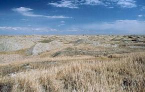
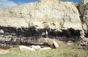
The top 15 feet
of the Harmon coal is exposed along East River Road north of Amidon, Slope
County. The Harmon and Hansen beds are stacked together in this area and
consist of about 40 feet of coal. The Harmon bed extends over an area of
at least 5,500 square miles in Bowman, Adams, Slope, and Golden Valley counties
and has been mined in eastern Bowman County since 1925. (Photo by E. Murphy, NDGS). |
|
 |
 |
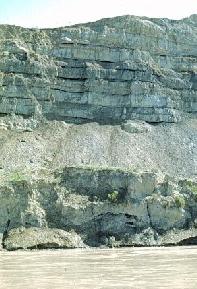
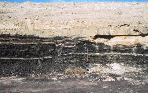
Seven thin coals
are present within a 30 foot interval of the Bullion Creek Formation exposed
along the Little Missouri River in northern Billings County. The repetitive,
thin coals indicate that changing environmental conditions such as fluctuating
water depths or clastic input was causing peat deposition to increase and
decrease across this interval. (Photo by E. Murphy, NDGS). |
|
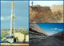
Currently, there
are six operations mining 32 million tons of coal annually in western North
Dakota. Four operations (the Freedom Mine north of Beulah, the Knife River
mine south of Beulah, the BNI mine at Center, and the Falkirk mine north
of Washburn) are mining coal to feed steam boilers for electric generating
plants in North Dakota. Two smaller operations (GeoResource's mine at Williston
and the American Colloid mine at Haynes) are mining Leonardite (oxidized
lignite) to be used in soil stabilization and as drilling fluid additives. |
|
 |
 |
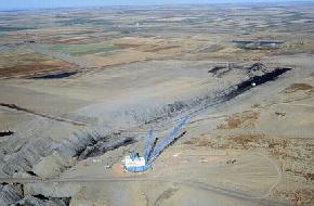
The Freedom Mine
is the currently the largest mine in the state mining approximately 16 million
tons of coal annually, equalling the total of all of the other mines combined.
About one third of the coal mined at the Freedom Mine is supplied to the
Great Plains Synfuels Plant for coal gasification. (Photo by E. Murphy, NDGS). |
|
 |
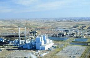 |
The Antelope Valley
electric generating plant is in the foreground and the Dakota Gasification
Company's (DGC) plant is in the background. The DGC plant currently has
the capability to produce 170 million standard cubic feet of gas per day
along with several marketable byproducts. (Photo by E. Murphy, NDGS). |
|
 |
 |
The GeoResource
operation just east of Williston is mining 6 to 15 feet of leonardite. The
leonardite is overlain by till on the left side of the photo and by both
outwash and till on the right side of the photograph. (Photo by E. Murphy, NDGS). |
|
Selected
References for North Dakota Coal |
|
Babcock, E. J., 1901, Report of the North Dakota Geological Survey; coal: North Dakota Geological Survey First Biennial Report, 103 p |
|
Brant, R.A., 1953, Lignite resources
of North Dakota: United States Geological Survey Circular 226, 78 p. |
|
Groenewold, G.H., Hemish, L.A., Cherry,
J.A., Rehm, B.W., Meyer, G.N., and Winczewski, L.M., 1979, The geology and
geohydrology of the Knife River Basin and adjacent areas of west-central
North Dakota: North Dakota Geological Survey Report of Investigation No.
64, 402 p. |
|
Leonard, A.G., Babcock, E.J., and Dove,
L.P., 1925, The lignite deposits of North Dakota: North Dakota Geological
Survey Bulletin No. 4, 240 p. |
|
Moran, S.R., Cherry, J.A., Fritz, Peter,
Peterson, W.M., Somerville, M.H., Stancel, S.A., Ulmer, J.H., 1978, Geology,
groundwater hydrology, and hydrogeochemistry of a proposed surface mine
and lignite gasification plant site near Dunn Center, North Dakota: North
Dakota Geological Survey Report of Investigation No. 61, 263 p. |
|
Oihus, C.A., 1983, A history of coal
mining in North Dakota 1873-1982: North Dakota Geological Survey Educational
Series No. 15, 100 p. |
|
Pollard, B.C., Smith, J.B., and Knox,
C.C., 1972, Strippable lignite reserves of North Dakota: United States Bureau
of Mines Information Circular 8537, 37 p. |
|