
|
NORTH DAKOTA NOTES NO. 12 |
![]()
North Dakota's Badlands
Rugged badlands carved from rocks ranging in age from Late Cretaceous through Eocene occur along the Little Missouri River in western North Dakota, USA.
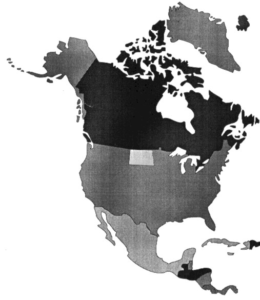
North Dakota, in the exact center of the North American continent (Fig. 1), is often considered to be the epitome of the Great Plains prairie environment - sparsely populated, flat to gently rolling plains, with flat-lying Cretaceous and Tertiary sedimentary formations and continental glacial topography. The area is sometimes characterized as cold and "boring" by people who haven't been here. Cold? Yes, the winters are among the coldest in the United States - 40oC is not uncommon. Boring? Absolutely not! North Dakota has a great diversity of unusual and outstanding glacial features that have attracted the attention of geologists from all over the world. It has an array of vertebrate fossil remains. The Cretaceous-Tertiary boundary, which marks the time the dinosaurs and many other life forms became extinct, is widely exposed in the state, and has been studied in detail.
 Figure
1. North Dakota is located in the exact center of North America.
Figure
1. North Dakota is located in the exact center of North America.
However, if you ask the average North Dakota resident what he or she knows about the state's geology, most will first mention the badlands. That's true too of visitors, many of whom come to North Dakota to see the scenic lands along the Little Missouri River. The badlands are easily North Dakota's best-known geologic feature.
The badlands are a hilly landscape, but on approaching them, you look down on the hills from above, not up at them. From the rim of the "breaks," as the descent into the badlands is called, you see a strip of sparsely wooded ridges, bluffs, buttes, and pinnacles. Behind, a rolling plain, broken only by an occasional butte, stretches away to the horizon.
The Sioux Indians, one of the tribes that inhabited the area when European settlers arrived, referred to the badlands as "makosika" ("land bad"). Early French explorers translated this and added to it, referring to "les mauvais terrers a' traverser" ("bad land to travel across").
Areas of badlands topography are found in several places on the plains of the north-central US and the adjacent prairie provinces of Canada where erosion can be intense. The largest and best-known badlands in the United States are the extensive exposures of Oligocene-age beds along the White River in western South Dakota. In North Dakota, layers of sedimentary rock equivalent to those in South Dakota are found near Dickinson, where badlands are carved from the Oligocene Brule and Chadron Formations. In both states these beds are notable for their abundant mammal fossils. Other areas of badlands topography include exposures of the Eocene Golden Valley Formation, also near Dickinson, and exposures of the Cretaceous Hell Creek Formation.
Paleontology
The Hell Creek beds contain dinosaur remains that have been extensively collected. The Hell Creek Formation, exposed in the southern portion of the Little Missouri badlands, was deposited at the end of the Cretaceous and contains remains of the last species of dinosaurs that existed on Earth. North Dakota Geological Survey geologists studying the Hell Creek have identified fossils of 14 species of dinosaurs, including Triceratops, duck-billed dinosaurs (hadrosaurs), Tyrannosaurus rex, pachycephalosaurs, the small raptor-like predators called dromaeosaurs and several others. Triceratops seems to be the most common of the dinosaurs in North Dakota. Fish, turtles, crocodiles, alligators, champsosaurs, lizards, amphibians, birds, and small mammals are other vertebrates represented by fossils associated with the dinosaur remains. Freshwater snails, mussels, pill clams and insects are also found in the Hell Creek Formation. Many species of exotic plants represented by leaf fossils, seeds, and pollen are found, including broad-leafed trees, cycads, palm trees, and ground ferns. These plants and animals inhabited a vast subtropical, coastal plain delta that covered western North Dakota during latest Cretaceous time.
The slightly younger Paleocene biota are represented by fossils in the more widespread Bullion Creek and Sentinel Butte formations. They inhabited a tropical to subtropical, swampy lowland area with meandering rivers and streams.
By the beginning of the Paleocene, the last of the dinosaurs had become extinct as well as about 75% of the Cretaceous flora. In North Dakota, after this extinction event, the dominant predators in the ubiquitous lakes, ponds, swamps, rivers, and streams were crocodilians (crocodiles, alligators, and the crocodile-like champsosaurs). Several kinds of turtles (including snapping turtles and soft-shelled turtles) and several kinds of fish (including gars) inhabited these aquatic habitats and were prey for the crocodilians. Several varieties of freshwater snails and clams also existed in these habitats. Birds and mammals, including lemur-like creatures, were also becoming more abundant, but their fossils are rare in North Dakota's badlands.
Little Missouri Badlands
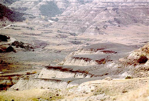
The most widespread and spectacular badlands in North Dakota border the Little Missouri River (Figs. 2 and 8), northward from the headwaters area in Wyoming, where they are developed in rocks as old as Cretaceous, to the point where the river flows into the Missouri River. Some exposures in the northern part of the Little Missouri Badlands are eroded from beds as young as Eocene age, but most of the area of the badlands along the Little Missouri River is carved from the Bullion Creek and Sentinel Butte formations, both of Paleocene age.
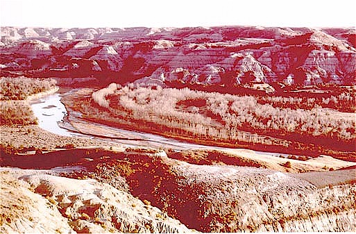 Figure
2. View east-southeast over the Little Missouri River, North Unit, Theodore
Roosevelt National Park. Note the narrow, arcuate bands of cottonwoods that
parallel the river channel. Each band marks the location of a natural level
deposit.
Figure
2. View east-southeast over the Little Missouri River, North Unit, Theodore
Roosevelt National Park. Note the narrow, arcuate bands of cottonwoods that
parallel the river channel. Each band marks the location of a natural level
deposit.
The sedimentary layers exposed in the Little Missouri Badlands are mainly continental sediments that were deposited by rivers and streams flowing east to the Dakotas from the Rocky Mountains in Montana and Wyoming at the time of the Laramide orogeny. They consist of layers of poorly lithified siltstone, claystone, sandstone, and lignite coal that were deposited in a coastal plain environment. River, floodplain, and swamp deposits predominate. Bluish gray layers of weathered volcanic ash form excellent marker beds in places and brownish gray layers of sand containing thin, orange, iron-rich bands also form prominent markers. Black veins of lignite coal are common and reddish bands of clinker (materials that were baked when buried lignite veins burned) add color to the area.
Lignite
As trees and other plants died and settled into the Paleocene swamps, they began to decay due to the action of bacteria in the anaerobic environment. When the streams changed course, they buried the partially decomposed vegetation (peat) beneath layers of silt and clay. With time, the weight of the overlying sediment helped to compress and transform the peat to lignite coal. A one-metre-thick bed of lignite might have resulted from a 10-m layer of peat and some of the lignite layers are more than 10 m thick.
Petrified Wood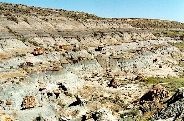
Figure 3. View of the two petrified wood beds on the Petrified Forest Plateau, South Unit, Theodore Roosevelt National Park.
Two zones of petrified wood are widespread in the southern part of the badlands area (Fig. 3). Petrified stumps reach up to 2 m high and typically over a metre in diameter at breast height (Fig. 4). Most of the stumps have fluted bases and, where in place, they rest on thin lignite coal beds or carbonaceous shale. The trunks are commonly somewhat flattened, compressed by the weight of the overlying sediments. Leaf fossils are abundant, but roots are not found.
The petrified wood
found in the North Dakota badlands is mostly light brown or cream colored in
contrast to the more highly colored varieties found in some areas of the southwestern
United States. Preservation of the wood is commonly poor, ranging from silicified
to "coalified" wood that tends to disintegrate when it is exposed
to weathering.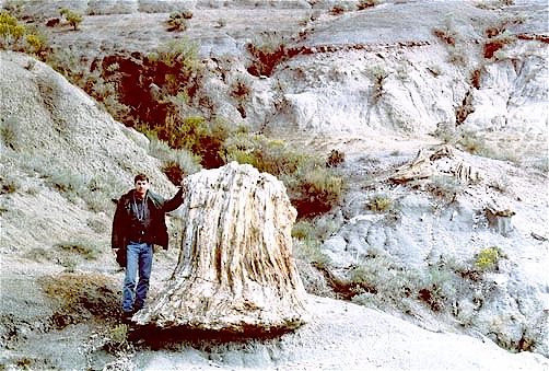
Figure 4. Large, upright petrified stump on the Petrified Forest Plateau, South Unit, Theodore Roosevelt National Park
Few studies have been done on the petrified wood, but because of the abundance of leaves associated with most of the stumps, it is inferred that many are the remains of the Dawn Redwood, Metasequoia. Sycamore, palm, and other exotic plants grew in North Dakota in the dense, subtropical forests.
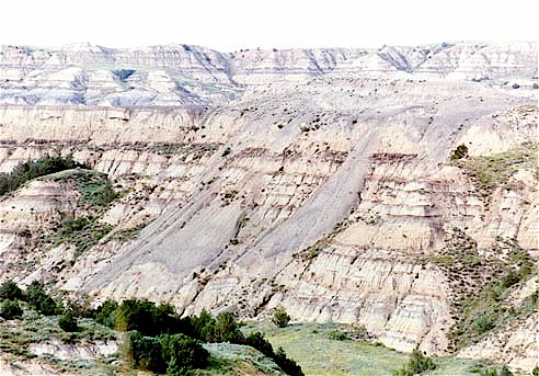
Bentonite Beds
 Figure
5. View west at bench-forming Sentinel Butte bentonite, North Unit, Theodore
Roosevelt National Park.
Figure
5. View west at bench-forming Sentinel Butte bentonite, North Unit, Theodore
Roosevelt National Park.
During the Laramide, volcanoes erupting to the west spewed ash that was carried by the wind to western North Dakota where it washed into wet areas - lakes and lagoons. With the passage of time the ash was transformed to bluish, bentonite clay layers that can be seen today in the badlands areas (Figs. 5 and 6). Bentonite is composed principally of the clay mineral montmorillonite, which if it contains sodium as an exchangeable ion, can swell conspicuously when wet; calcium bentonites are only slightly swelling or non-swelling. The Sentinel Butte bentonite is an iron- and sodium-rich montmorillonite, one of three major Paleocene-age bentonites in North Dakota shown to have been derived from volcanic ash. The bentonites in the badlands can absorb up to several times their weight in water and they are extremely slick and mobile when wet. They form a characteristic popcorn-like surface when dry (Fig. 7).
 Figure
6. When saturated, the Sentinel Butte bentonite slumps and flows downhill.
Figure
6. When saturated, the Sentinel Butte bentonite slumps and flows downhill.
Formation of the Badlands
Although the layers of sedimentary rock exposed in the Little Missouri Badlands range from Cretaceous through Eocene age, the badlands themselves - the hills and valleys - are not nearly that old. The Little Missouri River began to carve the badlands about 600,000 years ago, when a glacier diverted it from its northward course (Fig. 8). Prior to glaciation, the river had flowed northward to a confluence with the early Yellowstone River and thence northeastward into Canada and on to Hudson Bay.
After the glacier diverted
the Little Missouri River eastward, it flowed over a shorter, steeper route
than before. As a result, a vigorous cycle of erosion and downcutting began,
initiating badlands development. Thus, the badlands are ultimately a product
of glacier processes. Without glaciation, the Little Missouri Badlands would
not have formed.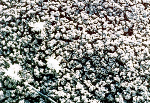
Figure 7. Typical "popcorn" covered surface of the Sentinel Butte Formation bentonite. Note mechanical pencil for scale.
About the only conspicuous evidence of glaciation remaining in the Little Missouri Badlands is the occurrence of glacial erratics in the northern part of the area. Patches of sand and gravel of glacial origin are also found on some buttes, overlying Sentinel Butte Formation beds. In addition to the areas of sand and gravel, a thin, widespread mantle of loess is present in upland areas, adjacent to eroded, badlands slopes and, in a few places, thin deposits of glacial till are found.
Erosion Rates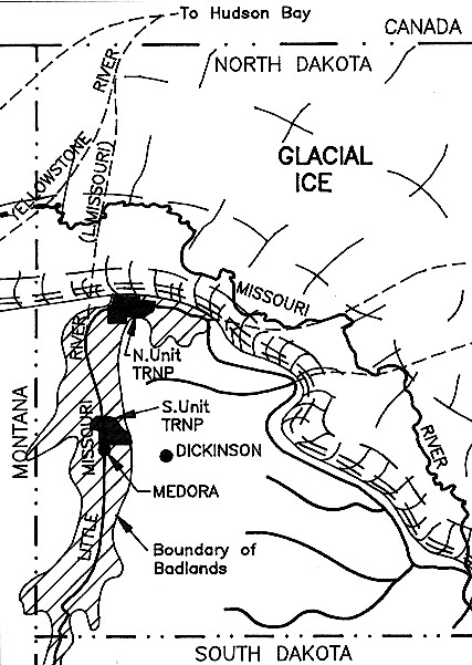
Figure 8. Diversion of the Little Missouri River by the glacier. Ice blocked the northward route of the Little Missouri River into Canada (dashed lines show preglacial routes of several rivers, including the Little Missouri River). The river was forced to flow eastward over a shorter, steeper route initiating downcutting and badlands formation. The route of the modern Missouri River was finally established much later, during Wisconsinan time. Lined pattern is extent of badlands topography.
A great amount of sediment has been eroded and carried away by the Little Missouri River since the Little Missouri Badlands began to form. In the southern part of the area, near the river's headwaters in northeastern Wyoming, the river has cut down about 25 m below the level at which it was flowing when the glaciers diverted it. Near Medora, the valley floor is 80 m lower than the pre-diversion level. Still farther north, near the confluence of the Missouri and Little Missouri Rivers, the east-trending portion of the river flows in a valley that has been incised to a depth of more than 200 m since glaciers diverted the river.
It can be calculated that the average rates of erosion are (approximately): Missouri-Little Missouri confluence area, 3 cm/100 years; Medora area, 1 cm/100 years; Headwaters area, 4 mm/100 years. Although these rates of erosion seem tiny, over time they have removed a huge amount of sediment. Approximately 200 km3 of sediment have been eroded and carried away by the Little Missouri River since the formation of the badlands began 600,000 years ago. Much of that sediment is now in the Gulf of Mexico.
The erosion rates just noted are averages. Erosion of the Little Missouri Badlands has actually taken place at highly irregular rates. During the past few hundred years, the badlands have undergone four separate periods of erosion and three periods of deposition. New gullies have been cut to their present depths since about 1936. Erosion is most intense during periods of drought when the vegetative cover is too sparse to protect the soil.
 Figure
9. Basal Sentinel Butte sandstone. Castellate and rill weathering, as well as
a variety of concretions, characterize this unit.
Figure
9. Basal Sentinel Butte sandstone. Castellate and rill weathering, as well as
a variety of concretions, characterize this unit.
Badlands are eroded mainly by slopewash (Fig. 9), not directly by streams and rivers. In places where vegetation is thin, the soil and rock materials are easily weathered, forming a loose surface that slips and slides down slope easily - by slumping and sliding during showers or when the snow cover melts.
Badlands Landforms
The individual shapes and configurations of the hills, buttes, valleys and other landforms in the badlands are not entirely happenstance. Differences in hardness of the materials cause differences in resistance to erosion. Variations in permeability have a similar effect; rain and melted snow tend to soak into the more open and permeable sands, causing little or no erosion, but when water flows over the surface of the tighter, less permeable sediments, such as clay, it erodes the materials over which it is flowing. The presence and kind of vegetation can also be important factors governing the rate of erosion.
 Figure
10. Oval and log-like sandstone concretions in the basal Sentinel Butte sand
at the Petrified Forest Plateau. Petrified stumps in the foreground and on the
ridge in the distance have been let down from erosion of the overlying petrified
wood beds. South Unit, Theodore Roosevelt National Park.
Figure
10. Oval and log-like sandstone concretions in the basal Sentinel Butte sand
at the Petrified Forest Plateau. Petrified stumps in the foreground and on the
ridge in the distance have been let down from erosion of the overlying petrified
wood beds. South Unit, Theodore Roosevelt National Park.
The shapes and configurations
of badlands landforms are also affected by the presence of nodules and concretions,
hard and resistant pods and lenses encased in more easily eroded materials (Fig.
10). The irregular placement of these less-easily-eroded materials sometimes
causes small, rock-capped pillars (known as "hoodoos") to form (Fig.
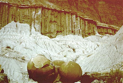
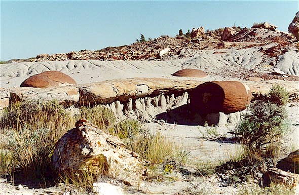
11). Some concretions and nodules are spherical ("cannonballs"), some
are long and tubular, and others have irregular shapes. In places, the land
surface in the badlands is covered by nodules of siderite (iron carbonate or
"ironstone"). As these nodules weather out of the surrounding materials,
they may form an erosion-resistant armor.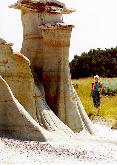
Figure 11. Some of the most spectacular hoodoos are found in the basal sandstone of the Sentinel Butte Formation.
Among the more conspicuous of the various types of larger concretions are the "logs," elongate sand bodies, which at first glance might be mistaken for tree trunks that have been transformed to petrified wood. These logs, however, are sandstone bodies that have been cemented, most commonly by calcium carbonate. The log-like concretions formed when mineral-rich groundwater seeped through porous and permeable zones in the buried sediments, depositing the minerals it contained in the sediment pores and cementing the sediments into concretions.
Erosional piping is common in places, especially in the Hell Creek Formation, but also in the Bullion Creek and Sentinel Butte Formations. The average depth of vertical pipes is about 3-4 m, but they can be as deep as 10 m in the Hell Creek. The pipes may be partially concealed and they can make hiking treacherous. Remains of animals, such as deer, are commonly found at the bottoms of pipes.
Clinker
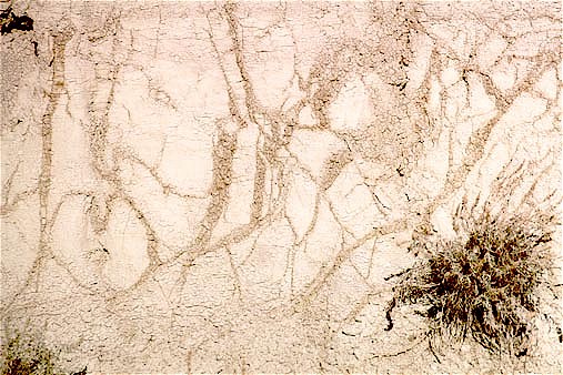 Figure
12. Close-up of Sentinel Butte ash, showing joints along which ash has been
altered to bentonite
Figure
12. Close-up of Sentinel Butte ash, showing joints along which ash has been
altered to bentonite
Layers of colorful clinker are widespread throughout the Little Missouri Badlands. The most extensive of these is the HT Butte clinker, which marks the contact between the Bullion Creek and Sentinel Butte Formations in places where the HT Butte lignite bed has burned. The HT Butte clinker, which is as thick as 15 m in some exposures, caps many small isolated hills and ridges. A thin layer of white ash, mostly potash, lime, and other inorganic incombustible minerals, is typically found at the base of clinker beds (Fig. 12). The clinker formed by repeated, comparatively small, discrete burns, the latest of which was from 1951-1977.
Clinker is a collective term for a variety of rock types produced by the burning of coal beds. It ranges from only slightly baked sediments, in which original sedimentary textures and structures (even fossil leaves) are preserved, to a glassy slag (Fig. 13). In between is a range of progressively altered baked sediments: a vesicular, frothy, brecciated mass reminiscent of volcanic scoria or even a very hard, fine grained, conchoidally fractured rock known as porcellanite. Clinker is most commonly reddish in color, but it varies from black to the palest pink depending on the composition, texture, and other characteristics of the original sediment and degree of oxidation or reduction achieved during burning.
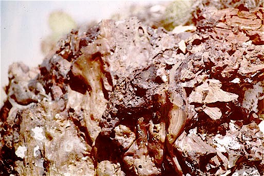
Figure 13. Partly melted, fused mass of vesicular HT Butte clinker.
Exposed lignite seams may catch fire when they are struck by lightning, when prairie fires burn over them, or they may ignite spontaneously. Clinker beds are especially striking after a shower, which intensifies their typical reddish coloration.
Conclusion
The geology of the North Dakota badlands is only part of the whole story - the climate, animals and birds, plants, insects - all of these need to be dealt with before the total badlands environment can be understood and appreciated.
I think the North Dakota badlands are especially beautiful because of the wooded areas that occur in many of the draws and north-facing slopes. The badlands along the Little Missouri River at the confluence of the Little Missouri and Missouri rivers are especially scenic because of the heavy vegetation in that area. Evergreens, such as the Rocky Mountain juniper, ponderosa, and creeping red cedar, are interspersed with trembling aspen, cottonwood, and poplar. Limber pines are found in the badlands in a few places in the southwest corner of the state. During times that veins of coal are burning, fumes alter the growth habits of the juniper trees, causing them to grow in tall, columnar shapes for many years. After the fires go out the trees revert to the typical, somewhat bush-like, juniper shape, common elsewhere in the badlands.
I've hiked and camped in the Little Missouri Badlands many times and, oddly enough, I think I enjoy them most at night when it's sometimes hard to accept that the stark, intricately eroded pinnacles are real. From a distance in the moonlight they appear like ruins of an ancient city rather than simple structures of sand and clay. Evening rains accentuate the colors almost beyond belief - the clinker beds take on intense and unique shades of red and orange - and the fresh smells of wet sage and cedar make one savor every breath. Coupled with the howling of coyotes, the overall effect is enchanting.
Photographs by Bob Biek
![]()
Suggestions for Additional Reading
Bell, G. L., and Petter, C. K., Jr., 1956, Buck Hill burning lignite bed, Theodore Roosevelt Memorial National Park, North Dakota: North Dakota Academy of Science Proceedings, v. 10, p. 25.
Bluemle, J. P., 1991, The face of North Dakota, revised edition: North Dakota Geological Survey Educational Series 21, 177 p.
Cherven, V. B., 1978, Fluvial and deltaic facies in the Sentinel Butte Formation, central Williston Basin: Journal of Sedimentary Petrology, v. 48, no. 1, p. 159-170.
Fastovsky, D. E. and McSweeney, Kevin, 1991, Paleocene paleosols of the petrified forests of Theodore Roosevelt National Park, North Dakota: a natural experiment in compound pedogenesis: Palaois, v. 6, p. 67-80.
Forsman, N. F., 1992, Tuffs in North Dakota, in J. M. Erickson and J. W. Hoganson, eds., Proceedings of the F. D. Holland, Jr., Geological Symposium: North Dakota Geological Survey Miscellaneous Series 76, p. 267-272.
Murphy, E. C., Bluemle, J. P., and Kaye, B. M., 1993, Auto Tour Guide to the North and South Units, Theodore Roosevelt National Park, North Dakota Geological Survey Educational Series 22, 30 p.
Royse, C. F., Jr., 1970, A sedimentologic analysis of the Tongue River-Sentinel Butte interval (Paleocene) of the Williston Basin, western North Dakota: Sedimentary Geology, v. 4, p. 19-80.
![]()
| ND Notes Main Page |