![]()
 |
NORTH
DAKOTA NOTES NO. 10 |
Drumlins in North DakotaBy John P. Bluemle
|
||||
| Drumlins are small hills, elongated in
the direction that the glacier was flowing. They are abundant in
Ireland, so it is appropriate that the name "drumlin"
is derived from an Irish Gaelic word, "druim,"
meaning "back" or "ridge." I've always
thought of classical drumlins, like the ones I’ve seen in
Ireland, as kind of like inverted spoons, but there they are
commonly referred to as "basket of eggs" topography.
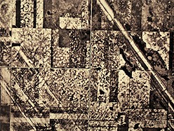
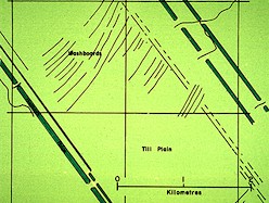
A typical "classical" drumlin is about 100 feet high and maybe 500 feet long by 200 feet wide. They are commonly about two or three times as long as they are wide. A drumlin usually has a blunt nose pointing in the direction from which the ice approached and a gentler slope tapering in the other direction. Several years ago when I was in Ireland, I spent some time working with an Irish geologist, studying drumlins north of Belfast. The drumlins he showed me typically have a base of gravel and sand — material that was obviously deposited by running water — along with a cap of glacial sediment that must have been plastered on by the moving ice, which also shaped the features. Drumlins like I just described are also common in the eastern United States, as far west as Wisconsin. I had a chance a few years ago to look at some drumlins near Boston, where they are abundant. The drumlins near Boston look just like those I saw in Ireland. So what has all of this to do with North Dakota? Well, we boast an array of features in north-central North Dakota that are similar in many ways to classical drumlins, but which are also really very different. We do call our North Dakota features drumlins, but I don't know if they formed in the same way as the Irish or Boston drumlins. Actually though, no one in Ireland has ever really explained how their drumlins formed either, although it's a topic they are very willing to argue about! It's a debate that's been going on for about a hundred years. Our features, which are best developed in McHenry County, in the area between Minot and Harvey, grade from drumlin-like hills with dimensions similar to the hills found in central Ireland, to features that are much more elongate. Much more. Because I've always been interested in drumlins, I did a study in 1987 with two University of North Dakota geology students on some of the extremely elongate drumlins in an area extending from near Verendrye to Balfour in McHenry County. About 200 of the ridges occur in the area, most of them with length-width ratios between 30:1 and 50:1. The most spectacular of the ridges is known as Hogback Ridge. Hogback Ridge is 17 miles long, about 375 feet wide, and 25 to 40 feet high along most of its length. Thus, instead of the 3:1 dimension typical of Irish or eastern U.S. drumlins, Hogback Ridge has a 240:1 length:width ratio (Figs. 1 through 4).
Hogback Ridge, along with all of the other drumlin ridges in McHenry County, trends from northwest to southeast, indicating the direction of glacier movement through the region. All of the drumlin ridges in the area are exceptionally straight, so straight in fact, that they might at first be mistaken for artificial features. Hogback Ridge resembles a large railroad or highway grade and, in fact, a segment of it was once used as a road. The ridge is bordered, on one or both sides, by long, narrow, pond-filled depressions.
In our study of Hogback Ridge, we made several backhoe excavations across the feature, both parallel and transverse to the length. We studied the internal sedimentary structures of the ridge and tried to determine how the feature formed. I'll summarize some of our conclusions. We decided that Hogback Ridge formed quickly, probably over the period of a year or two, and that it was shaped by a very rapidly flowing glacier. The glacier was very thin, and at the point where it crossed what is now the Souris River Valley near Verendrye, it picked up — thrust — a large block of material a short distance (see the "North Dakota Notes" article about ice-thrusting). After it had thrust this material, the glacier continued to flow over the block, which was probably about 40 or 50 feet high, and as it did so, a cavity formed at the base of the ice (Fig. 5). If the glacier had been thicker, the cavity would have quickly closed because glacial ice is plastic, but that didn't happen this time because the ice was too thin. The glacier was flowing over unfrozen ground, a kind of soupy mixture of glacial sediment plus sediment that had been deposited a short time earlier in a lake. As the cavity in the glacier advanced southeastward along with the rapidly moving ice, the weight of the ice on either side of the cavity forced the soupy material toward the cavity. As a result, material accumulated in the moving cavity as it moved, resulting in a long, straight ridge. So, we think we know how the Hogback Ridge formed. But why do we have a Hogback Ridge in North Dakota, a basket of eggs in Ireland, and inverted spoons in the eastern United States? Why not exactly the same kinds of features in all three places? Really, I can't answer that, but I can speculate (and often do). I think the difference is due to differences in the composition of the materials over which the glacier was flowing in the various places. In the eastern U.S. and in Ireland, the materials the glacier was moving over were sandy. In North Dakota, the predominant substrate beneath the ice was rich in clay. The clay flows much more easily than the sand, allowing much longer ridges to form. So even though the forces exerted by the glacier that caused drumlins to form are probably similar in both instances, the result was quite different because of the kind of materials the ice was flowing over. In all cases (North Dakota, Massachusetts, Ireland) it is necessary that the glacier have a thawed bed and that the melt water beneath the ice be able to escape. In Ireland, the water flowed out from beneath the glacier in a certain area — the area of the drumlin — depositing gravel and sand. As the water flowed out, it left behind a kind of "filter cake," plastered on top of the gravel, resulting in a classical drumlin. In North Dakota, the escaping water was tied more closely to the clay, making it possible for the weight of the ice to "squeeze" the materials into the ridge shape. The process was similar, if not identical, but the results were quite different. References: Bluemle, J. P., Lord, M. L., and Hunke, N. T., 1993, Exceptionally long, narrow drumlins formed in subglacial cavities, North Dakota: Boreas, v. 22, no. 1, p. 15-24, Oslo, Norway. |
 Figure
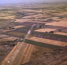
3. Oblique air view of the Hogback Ridge, McHenry County.
Figure
3. Oblique air view of the Hogback Ridge, McHenry County.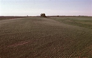 Figure
4. View of Hogback Ridge from the ground. In order to visualize the
shape and scale of the ridge, it’s necessary to see it from the
air.
Figure
4. View of Hogback Ridge from the ground. In order to visualize the
shape and scale of the ridge, it’s necessary to see it from the
air.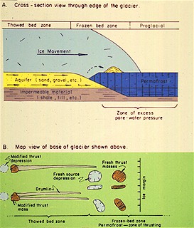 Figure
5. Diagram showing how drumlins form downglacier from ice-thrust hills.
Figure
5. Diagram showing how drumlins form downglacier from ice-thrust hills.