[ ]
]
[]
 |
GOLD IN NORTH DAKOTA by John P. Bluemle |
Gold in North Dakota? We get a lot of calls at the North Dakota Geological Survey from people, mainly from the eastern U.S., who want to come "out west" on vacation and prospect for gold. Many of them call us by mistake - they apparently confuse us with South Dakota, where gold is a major resource in the Black Hills.
Even so, the fact that small amounts of gold have been found in North Dakota has helped to maintain at least some interest in prospecting for it here. I'll describe three gold-mining ventures I am aware of and speculate a little on the possibility of finding economic deposits of gold in the state.
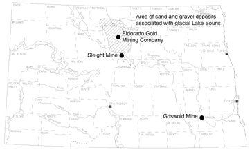
Map of North Dakota showing the locations of three “gold mines” that operated in the late 19th and early 20th centuries. The hatched area, mainly in McHenry County, is the sand and silt of glacial Lake Souris; small amounts of gold occur throughout this area (the Eldorado Gold Mining Company). The Sleight Mine tapped gold that had been deposited by water flowing southeastward out of glacial Lake Souris. The Griswold Mine, in Ransom County in southeastern North Dakota, exploited a cemented stream deposit of preglacial age. The gold was probably ultimately derived from the Black Hills of South Dakota.
.Ransom County - The Griswold Mine
The earliest "gold rush" in North Dakota that I know of took place in the southeastern part of the state, about 1884, when gold was discovered in the Sheyenne River valley about six miles north of Fort Ransom. The location of the mining operation, the "Griswold Mine," was in Sections 1 and 12, Township 136 North, Range 50 West.
The gold-bearing deposit there is probably a cemented placer, consisting of gravel that was deposited by a preglacial stream or river. The river flowed northeastward over the preglacial surface in Pliocene or early Pleistocene time, maybe two or three million years ago. It probably had its origin in the Black Hills, which was the likely source area for the gold.
When glaciers advanced over the area during the Ice Age, they completely covered the gold-bearing stream deposits with thick layers of glacial sediment. However, the modern Sheyenne River has eroded downward in the area, removing the covering of glacial sediment, and at the point where the Sheyenne River valley crosses the old preglacial river, the gold-bearing gravel has been exposed. The gravel is cemented by minerals deposited by groundwater that long ago seeped through the gravel, resulting in a concrete-like conglomerate. Springs occur where the cemented gravel is exposed along the wall of the Sheyenne River valley.
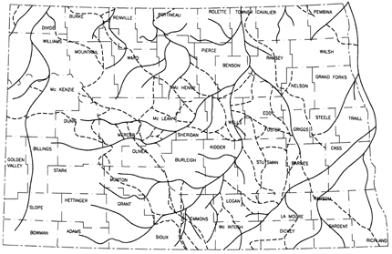
Stream gravels similar to the ones found near Fort Ransom are found along the Oahe Reservoir in Emmons County and in a few places in northwestern South Dakota, in areas that were not glaciated. The gravel deposits in South Dakota commonly occur as caprock layers on buttes and ridges. All of these gravel deposits were probably deposited by the same river or system of rivers that flowed from the Black Hills and crossed the Fort Ransom area before the area was glaciated (see map showing preglacial river system).
The Ransom County gold operation was known as the Griswold Mine. It apparently lasted about two years, but the material being processed did not contain sufficient gold to make the operation profitable. According to an engineering report published in 1936, the gravels there assayed between $5 and $11 per cubic yard, but I am unsure whether the assay referred to was done at the time the mine was in operation or whether it was done as part of the 1936 study.
Map of North Dakota showing the preglacial river system. A preglacial stream flowing northeastward from the Black Hills crossed Ransom County depositing small amounts of gold. After glaciers buried the stream deposit beneath thick glacial sediments, the gold-bearing stream deposit was excavated by the Sheyenne River late in the Ice Age. Denbigh Deposit - The Eldorado Mine
Since the early 1900s, gold has also been known to occur in the sand and gravel deposits associated with glacial Lake Souris in McHenry, Bottineau, and Pierce counties. The first discovery of gold there that I know about dates to May, 1908, when mining claims were recorded about three miles east of Denbigh in McHenry County.
I don't know exactly how much gold was involved in the Denbigh discovery, but by August of 1908, a company that called itself the "Eldorado Gold Mining Company" had been organized, and the articles of agreement stated that the participants would "cooperate and purchase a dredge or mining boat of sufficient capacity to do the work in the best possible manner." Several other similar companies were formed at about the same time, but the search for gold was unsuccessful and did not continue long. All of the companies soon ceased to exist.
The gold-bearing deposits associated with the glacial Lake Souris sediments in McHenry County were "rediscovered" in 1931 when reports from Chicago claimed that gold nuggets had been taken from the crops of turkeys grown near Denbigh. As soon as this information became general knowledge, the "rush" was on. Individuals and organizations filed placer claims and took mining leases until every available piece of ground over a large area surrounding Denbigh and Towner was covered.
So where did the gold actually come from? The gold contained in the glacial Lake Souris gravel deposits was apparently derived from rocks of the Canadian Shield to the north. The glaciers that transported the gold to north-central North Dakota flowed over what are today the Gods Lake, Flin Flon, and Lac La Ronge mining districts of northern Manitoba and Saskatchewan. This part of the Canadian Shield is situated about 500 miles straight north of the Denbigh area and, based on our understanding of the flow directions of the glacial ice, it is in a likely position to serve as a source for the gold.
After the glacial sediments were dropped by the melting glacial ice, they were washed by streams of meltwater, which helped to concentrate the gold by removing the lighter weight material. Finally, the gold-bearing sediments were deposited on the floor of glacial Lake Souris as undercurrent fans at the mouths of the Souris and other rivers.
No systematic method of prospecting or sampling was carried out in the Denbigh area in the 1930s, and rumors affirming and denying the existence of gold in commercial quantities were widespread. Many small plants, using a variety of methods of processing such as jigging, tabling, sluicing, cyanidation, and flotation were attempted. All operated unsuccessfully for short periods of time at various places throughout the area.
In the summer of 1934, the School of Mines at the University of North Dakota obtained assistance from the Federal Emergency Relief Administration (FERA) and conducted a "Gold Investigation" project. Approximately 1,500 samples from the Denbigh area were assayed and 200 showed traces of gold. About 40 samples had values ranging from $0.17 a ton (a value corresponding to a gold content of 0.005 oz. per ton) to $2.10 a ton (0.06 oz. per ton). These values are based on a price of $35 an ounce for gold; at a price of $400 an ounce, the material would range in value from $2.00 to about $24.00 a ton. The samples with these values were scattered over 15 different plots of ground and they failed to indicate anything of commercial importance in the area.
J. C. Allen, in a progress report of the 1934 FERA project, stated that, during the course of the study, more than 5,000 samples were collected and shipped to the School of Mines at the University of North Dakota for assay and laboratory testing. T. C. Barger, in 1937, summarized the FERA work project as follows:
"1. Gold is definitely present in the glacial gravel deposits [in the Denbigh area].
2. The gold particles are extremely fine.
3. The gold-bearing sands cover an immense area. Because of limited funds, it was not possible to investigate even all of the localities that had reported finding gold.
4. No deposits of commercial value were found in the areas prospected."
The particles of gold found in the Denbigh area were small, well-rounded pitted, and flattened grains. Their well-worn condition suggested that the gold had been subjected to stream erosion and weathering, similar to gold found in modern placer deposits. The largest nugget found in the FERA survey was about twice the size of a grain of wheat. I believe this is the largest single piece of naturally occurring gold ever found in North Dakota (if anyone knows otherwise, I'd appreciate hearing from you).
Bentley Lake Deposit - The Sleight Mine
Mr. John Alden Bethke, of Drake, recently related to Ms. Kay A. Buri that gold was once mined near Bentley Lake, about three miles west of the town of Drake in McHenry County (the lake was apparently originally known as "Brush Lake," but the name was changed to Bentley Lake to avoid confusion with a Brush Lake near the town of Mercer, McLean County).
Mr. Bethke said that the gold that was mined at Bentley Lake (located in Spring Grove Township: T. 151 N., R. 76 W.) was known as "flour gold," which is extremely fine-grained placer gold that is almost the consistency of flour; flakes of gold of this consistency are also known as "gold dust." A mine was attempted by Mr. T. E. Sleight at about the same time that the Denbigh area gold was being mined, about 1908. The venture was not economic and the amount of gold recovered did not warrant continuing the operation for very long.
The gold that occurred in the Bentley Lake area likely had the same source as the gold found near Denbigh. The same water that washed and sorted the glacial deposits to the north and deposited sediments in glacial Lake Souris also flowed southeastward out of Lake Souris, over the Bentley Lake area. As it flowed through the area, the water deposited gravel and sand, which apparently included small amounts of finely divided gold. As in the Denbigh area, only small amounts of gold were found. The likelihood of finding commercial concentrations of gold in the sediments related to glacial Lake Souris is only slight.
Summary
What are the chances of finding gold in commercial quantities in North Dakota? Not real good. However, the fact that even small amounts of gold have been found in the state has helped to maintain at least some interest over the years in prospecting for it.
To summarize, nearly all gold-bearing deposits occur near acidic, igneous intrusions; the Black Hills of South Dakota are the best-known nearby example. Gold deposit types include magmatic, contact metamorphic, replacement (as lodes, or massive bodies, or disseminated through the rock), and cavity fillings. None of these are found in North Dakota.
Gold can occur in association with a number of other minerals. Weathering and erosion can cause gold to be released from the above-described deposits, resulting in nuggets and grains, and in residual or stream placers. It is possible too, that gold may be found in some of the boulders that were carried to North Dakota by the glaciers from areas where gold occurs.
The gold that has been found in North Dakota got here in two ways. The deposits in McHenry County were delivered by the glacier, and then sorted by glacial meltwater. This gold was delivered to North Dakota during the ice age, probably about 15,000 years ago. The ultimate source of this gold was northern Saskatchewan. The Ransom County gold was carried to North Dakota in streams flowing northeastward from the Black Hills. This gold arrived in the state prior to the time the state was glaciated, probably more than 3 million years ago.
Many more "discoveries" of gold besides the two I described have been reported over the years in North Dakota, as well as a number of "scams" designed to incite "gold fever" and separate people from their money in various ways. I won't go into any of these schemes here. The fact that North Dakota has none of the rock types normally associated with gold-bearing deposits makes it unlikely that significant amounts of gold will ever be found here.
References
Allen, J. C. 1935, Glacial deposits of gold: North Dakota Engineer, v. 11, no. 3, p. 10.
Anderson, S. B., 1973, Gold: in Mineral and Water Resources of North Dakota, North Dakota Geological Survey Bulletin 63, p. 156-157.
Barger, T. C. 1937, Prospecting for gold in North Dakota: N. Dak., Univ., Div. of Mines and Mining Expts. Circ. no. 9, 5 p.
Barger, T. C. 1937, North Dakota gold: North Dakota Engineer, v. 13, no. 2, p. 7, 20.
Bluemle, J. P. 1987, Gold in North Dakota in, Bluemle, J. P., ed., Glacial Geology of Central North Dakota, Field Trip Guidebook, North Dakota Geological Society, Bismarck, ND, pp. 66-69.
Bluemle, J. P., 2000, The face of North Dakota, Third Edition: North Dakota Geological Survey Educational Series 26, p. 130-133.
Hansen, D. E., 1964, Gold in mineral resources of North Dakota: North Dakota Economic Development Commission, p. 117-118.
Harrington, L. C., [Chairman], 1935, A progress report of Committee on Mineral Resources to North Dakota State Fplanning Board: Division of Mines, University of North Dakota, unpublished report.
Harrington, L. C. 1937, Mineral resources report to Governor and 25th Legislative Assembly State of North Dakota, January 4, 1937: North Dakota State Planning Board, Mineral Resources Comm. Rept., mineo., 37 p., illus.
North Dakota Geological Survey
Last modified:
31-Aug-2007