|
THE PEMBINA ESCARPMENT by Allan Ashworth and John Bluemle |
|
THE PEMBINA ESCARPMENT by Allan Ashworth and John Bluemle |
[A version of this article appeared in the June, 1990 issue of the NDGS Newsletter. The first part of the article was written by Allan Ashworth, who is Professor of Geology at North Dakota State University in Fargo. Dr. Ashworth adapted material from an article he had written earlier, to accompany a field trip he helped lead on August 11, 1989: "Tales of the Tall Grass - The International Prairie Tour of the Lower Red River of the North." The lithographs reproduced here were included in an article by Manton Marble that appeared in Harper's New Monthly Magazine, August, 1860.
The second part of the article, dealing with the geologic origin of the Pembina Escarpment is a theory developed by John Bluemle].
The Pembina Escarpment, rising 300 to 400 feet above the Red River Valley in northeastern-most North Dakota and southern Manitoba, forms one of North Dakota's most dramatic landscapes. The hilly country, with cool ravines full of aspen and birch, stands in stark contrast to the flat lowlands to the east. The escarpment may have been one of the "mountains" referred to by the French fur trader, La Verendrye, in 1738. Certainly, by the time the first geologist explored the region, the hills were reputed to be the source of silver ore. However, William Keating, geologist to the U. S. Government's first expedition to the Red River Valley, led by Major Stephen H. Long in 1823, wrote:
"We saw no ore of any kind. The prairies do not present any character that would leave us to anticipate the discovery of mines in this neighborhood." Rumors persisted long after Keating's visit that coal and perhaps even gold existed on Pembina Mountain. David Dale Owen, geologist for the fledgling United States Geological Survey, visited the Red River in 1848. Owen, as Keating had discovered earlier, found no evidence for any deposits of economic significance.
In the more poetic language of the nineteenth century, Keating described the Red River Valley in a manner more vividly than any subsequent chronicler:
"The flatness of the surface that almost uniformly prevails throughout the Valley may be regarded as a defect in its natural character that cannot easily be remedied." Keating (in 1823), made the observation that the entire region had been covered by water: "The whole of the country may be considered to be an immense lake, interspersed with innumerable barren and rocky islands."
In 1852, David Dale Owen made the following comment: Pembina Mountain is " ... in fact no mountain at all, nor yet a hill. It is the terrace of table land - the ancient shore of a great body of water that once filled the Red River Valley. On its summit it is quite level, and extends so, for about five miles westward, to another terrace, the summit of which I was told is level with the great buffalo plains that stretch away towrds the Missouri, the hunting-grounds of the Sioux and the half-breed population of the Red River."
Owen had traveled northward, down the Red River, in 1848 and later written a report titled "Report of a Geological Survey of Wisconsin, Iowa, and Minnesota and Incidentally a Portion of Nebraska Territory."
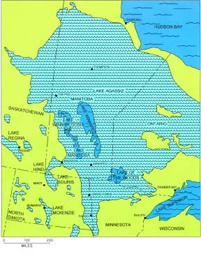
Interestingly, both Keating and Owen had anticipated the discovery of glacial Lake Agassiz (fig. 1). The existence of Lake Agassiz was not formally proven until the survey of its beaches by Warren Upham in 1881. Neither Keating nor Owen could have guessed the origin of the body of water to which they alluded. The very existence of an Ice Age, to which the lake owes its origin, was not proposed until 1840, by the Swiss scientist, Louis Agassiz.
The materials exposed in the Pembina Escarpment have their origins several millions of years ago, during the Cretaceous Period, long before glaciers invaded the Red River lowlands.
The shales and carbonates of the Cretaceous formations, exposed today in the deep gullies and valleys of the Pembina Escarpment, were deposited in a seaway that connected the Arctic Ocean to the Gulf of Mexico about 90 million years ago. Bones and teeth of fish, mosasaurs (large marine lizards, and pterosaurs (flying reptiles) are occasionally found in the Walhalla area and in the Morden area of southern Manitoba. The western shoreline of the
Figure 1. Extent of glacial Lake Agassiz. The lake extended south into northwestern Minnesota and eastern North Dakota, the area Keating and Owen visited in the first half of the 19th century. Cretaceous seaway, in western North Dakota and Montana, was the habitat of duck-billed dinosaurs, Triceratops, and Tyrannosaurs. The exposures of shale are interrupted in places by thin beds of yellowish-colored bentonitic clays. These bentonites are weathered volcanic ash beds. Clouds of ash, from volcanoes erupting in the developing Rocky Mountains, far to the west in Wyoming and Montana, blew eastward over North Dakota, settling in the shallow sea that covered the area.
After the Cretaceous seas drained, most of North Dakota and northern Minnesota underwent a long period of erosion during Tertiary time, between about 60 million years ago until about two or three million years ago. Although it is not known where or even in which direction rivers flowed in North Dakota during most of Tertiary time, by the end of the Tertiary Period North Dakota was drained by several rivers that flowed mainly to the north (fig. 2). The modern system of rivers in eastern North Dakota, such as the Sheyenne, James and Pembina rivers, did not develop until the end of the Ice Age.
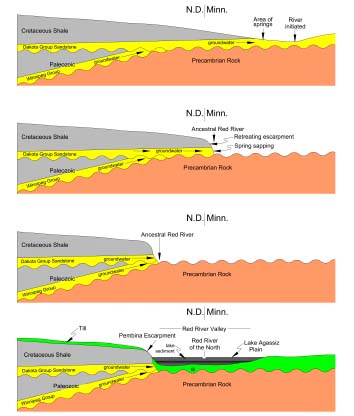
Figure 2. North Dakota's drainage pattern prior to glaciation. The entire state drained northward, ultimately to Hudson Bay. The formation of the Red River, and ultimately of the Pembina Escarpment ("Pembina Mountain" or "The Manitoba Escarpment" - several terms have been used for the same feature), was due to the springs emanating from the Cretaceous-age Dakota Group sandstone. This sandstone formation came to the surface in northwestern Minnesota (fig. 3). It was in that area of springs that the north-flowing Red River originated. Undercutting of the Cretaceous formations by spring sapping, coupled with erosion by the early Red River, resulted in the westward migration of the route of the river and the formation of Pembina Escarpment.
Figure 3. Steps in the formation of the Red River Valley and the Pembina Escarpment. Top diagram a cross section drawn from west to east along the U.S.-Canada boundary, shows the early Red River when it was located east of its present location. As the river eroded its way downward to the Precambrian rock, it shifted its course to the west (next two diagrams). The modern escarpment (bottom diagram) has been further modified by glaciers, which flowed southward through the valley, and by sedimentation in glacial Lake Agassiz.
The Cretaceous formations are preserved as an escarpment because the uppermost layer of rock, the Odanah Member of the Pierre Formation shale, is more resistant to erosion than are the lower formations (fig. 4). Spring sapping may have initiated the escarpment, but it was the glaciers that steepened it to near its modern configuration. Scouring of the face of the escarpment occurred on numerous occasions as the glaciers flowed southward, up the Red River Valley. Later, when glacial Lake Agassiz flooded the valley, storm waves generated on the lake accentuated the steep face of the escarpment. Massive outbursts of flood water from ice-dammed lakes to the west - glacial lakes Souris, Regina, and others - flowed along the Manitoba-North Dakota boundary, eroding the deep valley of the Pembina River. Finally, erosion since the end of the Ice Age has deepened the many small valleys in the face of the Pembina Escarpment and carved fresh exposures in the shale that can be seen today.Figure 4. The Cretaceous formations exposed in valleys along the Pembina Escarpment area. The more resistant Odahah Member of the Pierre Formation shale serves to keep the escarpment from eroding to a gentler feature.
North Dakota Geological Survey
Last modified:
30-Sep-2005