 People
like to draw lines on maps; it helps them to describe and know their
world. Politicians scribe political boundaries that guide the development
of government; hydrologists draw watershed boundaries that define individual
drainage basins; entrepreneurs chart transitory lines on maps that guide
their market development. Among the lines that geologists and geographers
use are those that define physiographic regions. North Dakota has been
so divided into six major physiographic regions, each defined by a suite
of characteristic landforms that serve to differentiate it from its
neighbors. People
like to draw lines on maps; it helps them to describe and know their
world. Politicians scribe political boundaries that guide the development
of government; hydrologists draw watershed boundaries that define individual
drainage basins; entrepreneurs chart transitory lines on maps that guide
their market development. Among the lines that geologists and geographers
use are those that define physiographic regions. North Dakota has been
so divided into six major physiographic regions, each defined by a suite
of characteristic landforms that serve to differentiate it from its
neighbors.
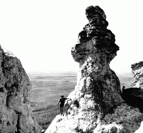
Pedestal Rock in the Killdeer
Mountains, circa 1911. The Killdeer Mountains
consist of two mesas that rise 700 feet above the surrounding
countryside in northern Dunn County. The rocks that cap the
mountain, shown here, consist of tuffaceous sandstone, siltstone,
and carbonates of the Arikaree Formation.
One of the best ways to "see" these
physiographic regions is by using a shaded-relief map. Such a map
vividly shows the dramatic differences in the landscape.
Certainly the new shaded-relief map of North Dakota (see pages
14-15) dispels the myth of the uniform, monotonously flat
countryside that many outsiders envision, and that sometimes even
locals, traveling at highway speeds, experience. The great, wide
open countryside at times makes it difficult to appreciate the
diversity of landscapes within one's view. When compressed onto a
page-size map, however, major topographic features are easy to
visualize.
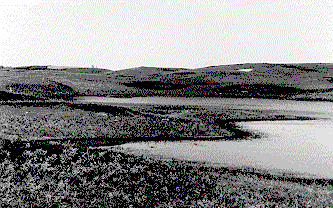
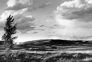 The
Coteau Slope of eastern Burleigh County. This rolling
to hilly area is characterized by both erosional and glacial landforms.
(R.F. Biek photo) The
Coteau Slope of eastern Burleigh County. This rolling
to hilly area is characterized by both erosional and glacial landforms.
(R.F. Biek photo)
The boundaries of these physiographic regions are not arbitrary,
not capriciously drawn like the misleading names hung on some suburban
streets. Each line reflects an important underlying geologic feature.
The Missouri Escarpment, for example, marks a prominent slope that
advancing glaciers were forced to push up and over, eventually leaving
behind a characteristic hummocky topography and innumerable prairie
potholes. The remarkably flat floor of the Red River Valley mirrors
the surface of the Ice Age lake, glacial Lake Agassiz, in which it
formed. Beaches and wave-cut scarps now mark the lake's former shorelines
and separate the valley from the glaciated plains to the west. Understanding
the state's physiography is very much understanding an outline of
the state's geologic history. 
Map identifying the major
physiographic regions in North Dakota. Even though
landforms of considerable variation occur within each region,
overall internal similarities make it possible to generalize
about the geomorphic processes that operated to shape each
region.
GREAT PLAINS
- Missouri Plateau: Rolling to
hilly plains except in badlands areas and near prominent
buttes.
- Little Missouri Badlands:
Rugged, deeply eroded, hilly area along the Little
Missouri River.
- Coteau Slope: Rolling to hilly
plains east of the Missouri River that have both
erosional and glacial landforms.
- Missouri Coteau: Hummocky,
glaciated landscape that resulted from collapse of
superglacial sediment.
CENTRAL LOWLAND
- Missouri Escarpment: Steep,
glacially modified escarpment that marks the boundary
between the Glaciated Plains and the Missouri Coteau.
- Prairie Coteau and Turtle Mountains:
Hummocky, glaciated landscape that resulted from collapse
of superglacial sediment.
- Glaciated Plains: Rolling,
glaciated landscape.
- Red River Valley: Flat plain
resulting from sedimentation on the floor of glacial Lake
Agassiz.
- Pembina Escarpment: Steep,
glacially modified escarpment that marks the boundary
between the Red River Valley and the Glaciated Plains.
- Souris Lake Plain: Flat to
gently sloping plain resulting from sedimentation on the
floor of glacial Lake Souris.
- Devils Lake Basin: Closed
drainage basin with drainage to Devils Lake; rolling,
glaciated landscape.
 The
Little Missouri Badlands are carved from 55-million-year-old river,
lake, and swamp sediments of the Fort Union Group. The
term "badlands" attests to the intricate, deeply dissected
nature of the land, with gullies, buttes, and a maze of short, steep
ridges that make travel through such areas difficult. The Sioux Indians
knew the badlands as "mako sica" ("land bad"),
while early French explorers translated this to "les mauvais
terres a' traverser" ("bad land to travel across").
(R.F.Biek photo) The
Little Missouri Badlands are carved from 55-million-year-old river,
lake, and swamp sediments of the Fort Union Group. The
term "badlands" attests to the intricate, deeply dissected
nature of the land, with gullies, buttes, and a maze of short, steep
ridges that make travel through such areas difficult. The Sioux Indians
knew the badlands as "mako sica" ("land bad"),
while early French explorers translated this to "les mauvais
terres a' traverser" ("bad land to travel across").
(R.F.Biek photo)
North Dakota lies within the Interior Plains,
that vast region stretching from the Rocky Mountains to the
Appalachians. In North Dakota, the Interior Plains are divided
into two major physiographic provinces by the Missouri
Escarpment. To the north and east of the escarpment lies the
Central Lowlands Province, characterized by its glacially
smoothed landscape. To the south and west, the Great Plains
Province rises gradually westward toward the Rocky Mountains. As
we shall see, the Missouri Escarpment, while prominent and
readily defined along most of its length, does not neatly
separate these two major physiographic divisions, but, as with
most things natural, the boundary is marked by a transition zone,
here called the Missouri Coteau.
The Great Plains Province is divided into the
Missouri Plateau (or Missouri Slope Upland), Little Missouri
Badlands, Coteau Slope, and Missouri Coteau. The Great Plains
Province thus contains both glaciated and non-glaciated regions.
Southwest of the Missouri River, the broad valleys, hills, and
buttes of the Missouri Plateau are largely the result of erosion
of flat-lying beds of sandstone, siltstone, claystone, and
lignite. These sediments belong primarily to the Paleocene-age
Fort Union Group and were deposited by ancient rivers flowing
away from the rising Rocky Mountains between about 65 to 55
million years ago. From about 10 to 5 million years ago, streams
began eroding the sediments that had so long ago been deposited,
dissecting the plateau with a series of rivers flowing northeast
to Hudson Bay. The modern landscape over most of southwestern
North Dakota thus formed over an exceptionally long period of
time, unlike the much more recent topography of the glaciated
portion of the state.
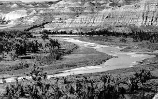
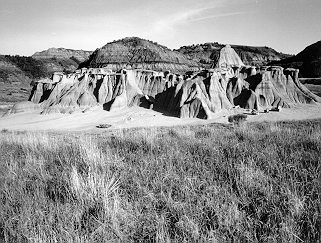 The
badlands of southwestern North Dakota are carved into an astonishing
variety of unusually shaped landforms. Shown here is
the lower Sentinel Butte Formation in the South Unit of Theodore Roosevelt
National Park. (North Dakota Tourism Department photo) The
badlands of southwestern North Dakota are carved into an astonishing
variety of unusually shaped landforms. Shown here is
the lower Sentinel Butte Formation in the South Unit of Theodore Roosevelt
National Park. (North Dakota Tourism Department photo)
The Little Missouri Badlands are carved into
strata of the Missouri Plateau. The badlands are a rugged, deeply
eroded area along the Little Missouri River that stretches from
Bowman County north to the confluence with the Missouri River.
The Little Missouri River began to carve the badlands about
600,000 years ago during Pleistocene time (the "Ice
Age") when the river was diverted by glaciers from its
northerly route into Canada. As a result of this diversion, the
Little Missouri River was forced to flow eastward over a shorter,
steeper route, thus beginning a cycle of vigorous erosion that
continues today.
 Typical
prairie pothole, formed by the melting of sediment-laden glacial ice.
As the ice melted, the sediment slumped and slid into low areas, creating
small hills. The small lakes, or potholes, generally occupy areas
where the ice persisted the longest, preventing them from becoming
filled with sediment. (J.P. Bluemle photo) Typical
prairie pothole, formed by the melting of sediment-laden glacial ice.
As the ice melted, the sediment slumped and slid into low areas, creating
small hills. The small lakes, or potholes, generally occupy areas
where the ice persisted the longest, preventing them from becoming
filled with sediment. (J.P. Bluemle photo)
The spectacular variety of landforms found in the
Missouri Plateau and Little Missouri Badlands results primarily
from the differences in resistance to erosion among Fort Union
Group strata. Buttes, for example, form when easily eroded
sediments are protected by a hard layer of sandstone or
limestone. Where beds of lignite have caught fire and burned,
adjacent sediments are baked and fused into a natural brick-like
material called clinker. The bright red clinker also shields
underlying sediments from erosion. In other places, mineralized
groundwater circulated through the sediments, forming flint,
petrified wood, silcrete, and concretions and nodules of all
shapes and sizes, all of which, being harder than the enclosing
sediments, resist erosion and so accumulate at the surface.
Although part of the Missouri Plateau south and
west of the Missouri River was glaciated during the Pleistocene,
in most places the only visible evidence of glaciation is an
occasional erratic boulder or thin patch of glacial sediment. The
glaciations that affected these areas were early ones that
occurred long before the glaciations whose deposits and landforms
are so evident in the eastern and northern parts of the state.
Presumably, most of the evidence of these early glaciations -
thick glacial sediments and glacial landforms - was removed by
erosion over the past several hundred thousand years.
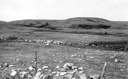 Boulder-covered
surface of the Missouri Escarpment. Slopewash has removed
some of the finer grained sediment, leaving behind a lag deposit of
boulders. (J.P. Bluemle photo) Boulder-covered
surface of the Missouri Escarpment. Slopewash has removed
some of the finer grained sediment, leaving behind a lag deposit of
boulders. (J.P. Bluemle photo)
North and east of the Missouri River, the Great
Plains Province differs markedly from that south and west of the
river, principally because evidence of glaciation is so fresh and
clear. Here it is divided into the Coteau Slope, a rolling to
hilly land with both erosional and glacial landforms, and the
Missouri Coteau, a hummocky landscape characterized by
innumerable prairie potholes. Because of its distinct glacial
character, many geologists consider the Missouri Coteau to be
part of the Central Lowlands Province. The Missouri Coteau does
in fact share features of both the Central Lowlands and the Great
Plains provinces and so perhaps it would be best to think of the
Coteau as a transition zone between the two regions.
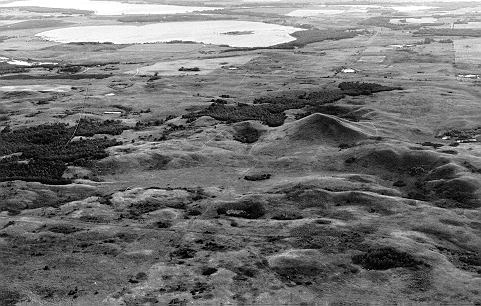
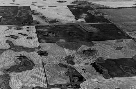 Aerial
view of typical collapsed glacial topography in Nelson County, North
Dakota. Note hummocky surface with numerous prairie
potholes. (J.P. Bluemle photo) Aerial
view of typical collapsed glacial topography in Nelson County, North
Dakota. Note hummocky surface with numerous prairie
potholes. (J.P. Bluemle photo)
The Missouri Coteau trends through the state,
parallel to and east of the Missouri River. It consists of
hummocky topography - thus the Canadian French coteau meaning
"little hill" - characterized by unintegrated drainage
(meaning that ponds and sloughs are not connected to one another
and no streams flow through the area). The landscape of the
Missouri Coteau formed because glaciers were forced to advance up
a steep escarpment before they flowed onto the uplands. As
glaciers advanced over the escarpment, sediment from the base of
the glacier was forced up to the surface. When the climate
moderated and the glaciers stagnated, sediment melting out of the
ice accumulated at the surface, insulating the ice so that it
took several thousand years to melt completely. As it melted,
sediment slumped and slid forming the hummocky topography.
Prairie potholes are most numerous where large-scale glacial
stagnation processes dominated.
The topography of the Turtle Mountains and the
Prairie Coteau formed in a similar manner to that of the Missouri
Coteau. They are erosional bedrock outliers draped with glacial
sediments. They, too, are characterized by a hilly, irregular
topography with many small ponds and lakes.
The Coteau Slope is a rolling to hilly region
that contains both glacial and erosional landforms. Unlike the
Coteau that bounds its eastern margin, drainage within the Coteau
Slope is generally well developed, so that there are
comparatively few potholes. The north and east margin of the
Missouri Coteau is marked by the Missouri Escarpment. The
escarpment is a prominent feature along most of its length, in
places rising 600 feet above the comparatively level terrain of
the Glaciated Plains.
 Devils
Heart Butte, located south of Devils Lake in Benson County, North
Dakota. This 175-foot-high hill occurs in association
with intensely ice thrust topography. It is composed of sand and gravel
and may have formed a "veblin," a hydrodynamic blowout feature,
when high-pressure groundwater flowed to the surface during glacial
thrusting. (J.P. Bluemle photo) Devils
Heart Butte, located south of Devils Lake in Benson County, North
Dakota. This 175-foot-high hill occurs in association
with intensely ice thrust topography. It is composed of sand and gravel
and may have formed a "veblin," a hydrodynamic blowout feature,
when high-pressure groundwater flowed to the surface during glacial
thrusting. (J.P. Bluemle photo)
The Glaciated Plains is a rolling, glaciated
landscape also known as the drift prairie. Much of the region is
very gently sloping, in contrast to the deeply dissected Missouri
Plateau. In other places, the ice shoved and thrust large masses
of rock and sediment, forming ice-thrust hills near the ice
margin. In still other areas, loose accumulations of rock and
sediment piled up at the edge of a glacier, resulting in areas of
especially hilly land called end moraine. Even where the
landscape harbors only the gentlest of swales, interesting
landforms can be seen. Washboard moraines, for example, create a
corrugated landscape, each marking a small ice thrust zone.
Shorelines of glacial lakes, large channels carved by
catastrophic floods of glacial meltwater, sinuous ridges of sand
and gravel called eskers, and a variety of other glacial
landforms are found on the Glaciated Plains. The Glaciated Plains
contain some of the most remarkable glacial features to be found
anywhere.
Most of these landforms were shaped very late in
the Pleistocene by the most recent glaciation, known as the
Wisconsinan, which spanned the time from about 70,000 until
10,000 years ago. Even though earlier glaciations played an
important role in shaping the landscape, the changes they wrought
are largely concealed, buried beneath more recent glacial
deposits.
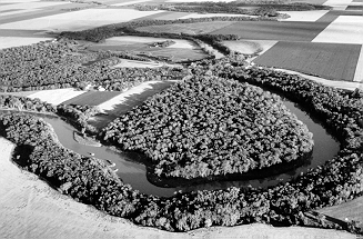 The
Red River of the North. The Red River meanders across
the flat floor of glacial Lake Agassiz. (North Dakota Tourism
Department photo) The
Red River of the North. The Red River meanders across
the flat floor of glacial Lake Agassiz. (North Dakota Tourism
Department photo)
The Red River Valley is an exceptionally flat
plain that marks the former floor of glacial Lake Agassiz, once
the largest fresh water lake in North America. The valley covers
a strip of land about 30 to 40 miles wide on either side of the
Red River in North Dakota and Minnesota. The central portion of
the valley is characterized by flat-lying silt and clay deposited
on the lake bottom. The blackboard-like surface of the lake plain
records its most recent history, including grooves scratched into
its surface by icebergs and differential compaction ridges that
outline the course of buried river channels. Along its margins,
ancient beaches and wave-eroded scarps mark former shorelines.
These beaches and scarps mark the eastern margin of the Red River
Valley, and they are the southward continuation of the Pembina
Escarpment. The Pembina Escarpment is most prominent in
northeastern North Dakota where it rises 400 to 500 above the
flat floor of the Red River Valley. There, it consists of a
glacially modified bedrock escarpment, the eastern edge of a
tableland of Cretaceous marine shales.
The Souris Plain is also an exceptionally flat
plain, one that marks the former floor of glacial Lake Souris.
Glacial Lake Souris flooded much of McHenry, Bottineau, and
Pierce Counties for no more than a few hundred years at the close
of the Ice Age. It had drained from North Dakota about 12,000
years ago. Flat-bedded clay and silt is found near the center of
the lake plain, but much of the area flooded by glacial Lake
Souris consists of glacial till that was washed by waves at the
lake shore. Much of the southern half of the lake plain is
covered by wind blown sand, part of the delta that formed where
the Souris River entered the lake.
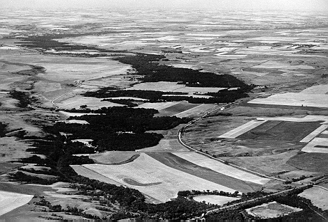 The
Sheyenne River valley, one of many, deep, steep-walled glacial outburst
channels in the Glaciated Plains. Channels like this,
now occupied by comparatively small rivers and intermittent streams,
were carved at the close of the Ice Age by catastrophic floods of
glacial water. (J.P. Bluemle photo) The
Sheyenne River valley, one of many, deep, steep-walled glacial outburst
channels in the Glaciated Plains. Channels like this,
now occupied by comparatively small rivers and intermittent streams,
were carved at the close of the Ice Age by catastrophic floods of
glacial water. (J.P. Bluemle photo)
White Butte, at 3,506 feet above sea level in
the southwestern corner of the state, is the highest point in
North Dakota. The lowest point in the state is 750 feet above sea
level, where the Red River crosses into Manitoba. At its most
basic then, North Dakota forms a gentle plain that slopes
northeast. But this surface is greatly modified by landforms
created by glacial ice, glacial lakes, and catastrophic floods of
glacial meltwater, as well as by the relentless erosion by water
and wind that created the buttes and badlands of the southwestern
part of the state. Through the eyes of a geologist, the North
Dakota landscape is tremendously varied, ranging from
exceptionally flat plains of glacial lakes to rugged badlands.
|
