[ ]
]
[]
 |
CAVES IN
NORTH DAKOTA
by Ed Murphy |
The well-known cave systems throughout the country formed over millions of years as groundwater flowed through and dissolved carbonate rock. Except for the Killdeer Mountains, North Dakota has no deposits of thick carbonate rocks at or near the surface, although thin carbonate beds do cap many small buttes in eastern Stark and Hettinger counties, and Paleozoic carbonates are present as shallow as 200 to 300 feet beneath the surface in the Red River Valley. As a result, North Dakota does not have a large near-surface cave system such as Mammoth Cave, Kentucky or Carlsbad Caverns, New Mexico. One of the few caves in the state does occur, at least partly, in carbonate rocks in the Killdeer Mountains, but it was formed by slope failure, not dissolution. Several features in the state fit Webster's definition of a cave as "a hollow place inside the earth" and have historically been referred to as caves. The two most prominently mentioned are Medicine Hole in the Killdeer Mountains and Ice Caves in Billings County. All of the "caves" in the state are a result of erosion or slope failure.
The primary source of information for this article was the WPA Guide to 1930s in North Dakota published in 1990 by the State Historical Society of North Dakota. Inthe 1930s and early 1940s, the WPA (Works Progress Administration) set out todocument the occurrence of interesting things (be it historical, geographical, or geological) in the state. This was done under the direction of the North Dakota Writer's Project, the records of which are housed in the North Dakota Heritage Center. Several additional "caves" are listed in these records and are discussed in this article as a means of presenting as complete a list of caves in the state as is possible, with, however, the understanding that most if not all of these sites are not what we traditionally think of as caves.
Several additional reports of caves were found in the records of the State Historical Society (Jim Davis, personal communication, 1995). These include Keller Cave Hole near Strasburg, Condo Cave near the site of the old Northern Pacific freight house in Bismarck (Williams County Leader: July 29, 1909), and Washburn Cave 30 miles north of Bismarck (Bismarck Weekly Tribune: June 3, 1887).
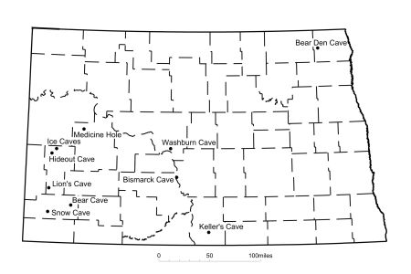
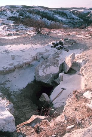
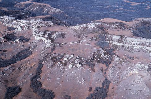
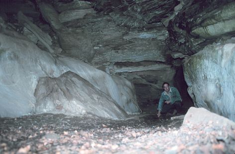
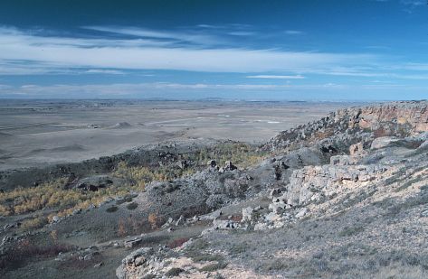
Medicine HoleMedicine Hole Plateau is located on the southeast edge of South Killdeer Mountain, Dunn County (T146N, R96W section 27). The site overlooks the abandoned hamlet of Oakdale. The small, narrow plateau is developed on tuffaceous (volcanic rich) carbonates and sandstones of the Arikaree Formation (Oligocene-Miocene); it rises 600 to 700 feet above the surrounding countryside and is 100 feet below the top of the mesa. Medicine Hole, located near the southern edge of this plateau, has long been a special place for locals and tourists because of the mysterious appearance of the hole and the scenic vista offered of the area from the plateau. A rugged trail leads from a small park on the southeast corner of South Killdeer Mountain up to Medicine Hole Plateau. Native Americans were also intrigued by the site. One version of Indian folklore contends that the first buffalo emerged from the earth at Medicine Hole, and another attributes Medicine Hole as being the place from which all life emerged.
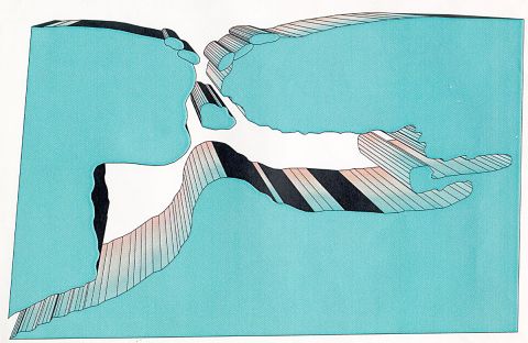
Medicine Hole is an east-west trending crack or fissure that resulted when a block of Arikaree strata broke away from the mountain. The crack runs for approximately 100 feet and the opening is less than 2 feet wide. The cavern varies from 5 to 30 feet high, and the deepest point is approximately 70 feet below the surface (Forney, 1977). The crack apparently has an exit because air can be felt escaping from the entrance at the top of the plateau. Medicine Hole may connect with a rattlesnake den which is present to the southwest approximately 80 feet below the top of Medicine Hole Plateau.
Several additional cracks or fissures were noted by T.T. Quirke in his 1914 map of the Killdeer Mountains. I found that several of the reported fissures on the northwest end of North Mountain had been filled in but I was unable to locate a cave that he noted beneath the caprock along the southeast end of North Mountain.
Fissures or cracks resulting from slope movement (such as rock topples or gravity slides) are generally present in the caprock of buttes in western North Dakota.- Medicine Hole in winter. This photograph was taken in 1985. In more recent years the rocks that were placed over part of the entrance to discourage cavers have been removed. Spelunker Jerry Forney noted while exploring Medicine Hole that there was a pile of pebbles on the floor of the cave below the opening which had formed from people over the years dropping pebbles to test the depth of the 70 foot-deep crack. Aerial photograph of the southeast end of South Killdeer Mountain. The trail leading up to Medicine Hole Plateau is visible in the foreground.
I have walked the perimeter of all of the major buttes in western North Dakota (Sentinel Butte, Square, Black, White, Chalky, East and West Rainy, etc.) and have come across only one cave that extended more than 12 feet into the rock.
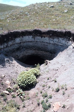
Ice CavesThe Ice Caves, also known as O'Brien Ice Caves (named for a long-time ranching family south of the caves) or Wonderful Ice Caves, are located on the northern edge of Billings County along the drainage of Magpie Creek (T144N, R100W section 6). The Ice Caves were reportedly discovered by Joe Quinion or John O'Brien in the early 1900s (Dickinson Press, 1995). The Ice Caves are located along the southern slope of a ridge capped by 30 feet of fluvial channel sandstone in the Sentinel Butte Formation. Large blocks of sandstone have become detached from the ridge cap and toppled or slid down the slope. Many of these blocks have come to rest at various angles against other large blocks, which has created void spaces or chambers.
Percolating water from melting snow and early spring rains drips into these well-insulated chambers where it freezes and remains frozen into late spring or summer. The largest chamber is approximately 30 feet long, 10 feet wide, and 9 feet high. When I visited this area in May, 1988, there were 2 to 3 inches of ice on the floor of many of these chambers. It has been reported that ice remains in some of these areas
into late summer and, in some instances, year round. The insulation offered by the thick sandstone blocks and the restricted air flow due to the single main openings in the chambers is the reason that ice is preserved for weeks or months after it has melted everywhere else.
In the 1920s, William Brennen placed butchered beef in the caves and was able to keep it fresh through the summer, although there were problems with animals getting in and helping themselves to the meat. In the early days, the caves were a popular attraction as people would come from miles around to picnic in the area with the highlight of the trip being the making of ice cream from the available ice.Snow Cave The inside of this, the largest Ice Cave, measures approximately 30 feet long, 10 feet wide, and 8 feet high. This cave is the space left between four or five blocks of sandstone. I am pointing to ice on the floor of the cave. Photograph taken near the entrance Snow Cave was located on the south side of Black Butte (originally called HT Butte), Slope County (T134N, R102W N1/2 section 25). As with the O'Brien Ice Caves, Snow Cave reportedly was a void space or chamber formed when several sandstone blocks in the Sentinel Butte Formation calved off of the caprock of Black Butte. Etha Lawson, a long-time resident of the Black Butte area, recalled that in the 1930s, local ranchers would picnic beside the cave and make homemade ice cream just as they did during this same time period at the O'Brien Ice Caves.
According to local rancher Doug Pope, falling rock and erosion over the years have destroyed Snow Cave. Therefore, the same processes which formed Snow Cave also led to its destruction. These same processes, the calving of sandstone blocks from the thick caprock and subsequent erosion, will continue to alternately form then destroy these ice caves until the butte ultimately erodes away.
The southwest edge of Black Butte, Slope County. Note that numerous sandstone blocks litter this slope. These blocks broke from the caprock and toppled and slid down the slope. Snow Cave was located in this general area. Bear Cave
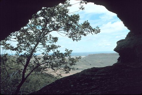
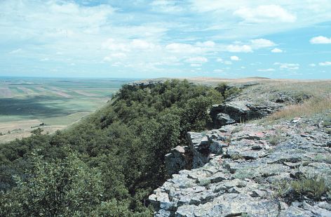
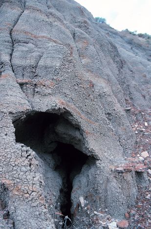
Bear Cave is situated in the Arikaree sandstone caprock along the northeastern edge of East Rainy Butte (T135N, R98W northeast section 34). It extends approximately 12 feet into the rock and narrows in height from 5 feet to two feet. This depression was carved out of the rock largely by wind and rain brought in by the prevailing northwest winds. Just a few hundred yards west of Bear Cave is the largest cave that I have encountered in any of the sandstone-capped buttes in western North Dakota. Although it might be more appropriate to refer to this larger cave as "Bear Cave", the smaller cave matches the dimensions given for Bear Cave by the WPA Guide. The entrance to the larger, north-facing cave is approximately 9 feet above the base of the sandstone caprock and 8 feet below the top of the butte. The shear face of the caprock in this area makes entry into the cave difficult. This cave extends at least 25 feet into the caprock, averages 3 feet in height, and obtains a maximum height of 4.5 feet just inside the 4 foot by 3 foot cave entrance. The irregular nature of the roof of this cave provides evidence that blocks of sandstone calved from the roof. These blocks have been broken down and removed from the floor of the cave by a combination of erosion, burrowing animals and perhaps humans. The floor of the cave is littered with scat which, according to landowner Ken Urlacher, likely is porcupine, skunk, or raccoon, all of which are reportedly abundant in this area. Judging from the relatively few initials that have been carved into the cave wall as compared with the adjacent Bear Cave, few have ventured into this cave.
Both of these East Rainy Butte caves formed in conglomeratic lenses near the middle of the sandstone caprock. These lenses are more susceptible to erosion because they are not as well cemented as the surrounding sandstone and contain easily weatheredPhotograph of entrance of Bear Cave from the back of the cave looking towards the town of New England The northeast edge of East Rainy Butte. Both of the caves mentioned in this article are located in this area. clay clasts. Additional caves are reported to be present at the same horizon on West Rainy Butte. The larger cave is situated in a north-trending joint which likely aided in its development by providing a passage way for infiltrating water. Burrowing animals and Native Americans may have aided in the forming of these caves.
The entrance to East Rainy Butte is locked and permission must be obtained from landowner Ken Urlacher before venturing up on this butte.
Lions CaveLions Cave is reportedly located on the side of Bullion Butte, Billings County. It was named for a pair of mountain lions that made their den there and harassed cattle during the late 1890s. I was unable to locate this cave although there are numerous overhangs in the caprock along the north and northeast edge of the butte.
Hideout Cave
Hideout Cave is located in northern Billings County (T144N, R101W section 26). The space was reported to measure 12 by 16 feet and is 8 to 10 feet high. During World War I, two draft evaders hid from the local draft board in this cave subsisting on wild game and supplies hauled by a friend from the town of Gorham. The pair stayed in the cave for 1 1 /2 years before leaving for Canada where they reportedly enlisted in the Canadian army. I was not able to find this cave. There are two channel sandstones in the Sentinel Butte Formation in this section (at an elevation of 2400 and 2600 feet). If the cave was located in either of these two sandstones it may have survived to the present. If the cave was an erosional feature that developed in mudstone in this area, it likely has been destroyed.
Bismarck Cave
On July 29, 1904, the Williams County Leader reported the existence of a cave near the Northern Pacific freight house in Bismarck (T138N, R80W section 5). The freight house was located along the river bank south of the Bismarck railroad bridge. The cave was discovered when a team and wagon sank 8 feet into the ground while being loaded with fruit from a railroad car. Orland Davidson, an old Indian Scout, remembered that, during the early days of Bismarck, a band of cattle rustlers occupied the cave and upon further investigation several old weapons and some ammunition was found. No other record of the cave has been found and it likely was an erosional pipe formed as runoff flowed into the Missouri River.
Washburn Cave
The June 3, 1887 edition of the Bismarck Tribune noted the discovery by two Bismarck men (Isaac Clark and Isaac Ross) of a cave thirty miles north of Bismarck. The entrance of the cave was 10 feet high and 6 feet wide and was marked by three large rocks. The pair reported that the cave was over 100 feet long and with a middle passage way that measured 12 by 12 feet. They noted that beads were found in the cave and that notched stones were strewn about that had likely been used to tether horses. On the entrance to the cave was the following inscription:
ANTOINE FRENOREJuly 24, 1851
Born 1824
600 Lodges Have Camped Here
The Tribune reported that a scientific party was being assembled to explore the cave but Jim Davis (State Historical Society of North Dakota) and I have been unable to find any other references to this cave in subsequent Tribune articles. It may have been an outright hoax, or the size may have been greatly exaggerated. From the crude location given by the Tribune it could have been located in northwestern Burleigh, southeastern McLean, or southwestern Sheridan counties.
Keller Cave
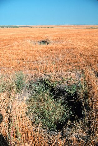
In the early 1970s, a hole opened up on the Keller farm near Strasburg in Emmons County (T131N, R75W near the center of section 16). Frank Vyzralec, formerly with the State Historical Society of North Dakota, and several others investigated the site and determined that most of the hole was only a few feet deep but on one end the opening extended 7 feet below the surface and was at least 20 feet long. Over the last twenty years, the depression has grown through surface collapse from roughly 2 by 4 feet to 5 by 12 feet and an additional hole has opened up 50 feet away. Both the longest dimensions of the holes and holes themselves are aligned on a northwest-southeast trend. The site is located in glacial drift on a small
topographic high which does not appear large enough to generate the runoff that would be needed to create an erosional pipe this size and there is no apparent exit which is needed for an erosional pipe to form. However, the northwest-southeast orientation is roughly parallel to some of the major drainage channels in this area. The general shape of the cave suggests it may have been a den, although no direct evidence was observed that would support this.
Above: Two collapse features at the Keller Cave site. The holes are spaced 50 feet apart on a northwest-southeast trend. The holes may have an underground connection.Left: The northwest edge of the northern hole contains a small cave or den that extends 7 feet below the surface.
Bear Den Cave
Bear Den Cave is located 3 miles south of Walhalla, just north of Highway 32 in Pembina County (T163N, R56W southwest of section 32). It reportedly is located midway between a spring and Eagle Lake. Bear Den Cave was named by people in the area who assumed it had been the den of a bear. As it turns out, it was created by George Emmerling in 1882 when he dug into the hillslope to find rocks for the mill he was constructing.
Erosional Pipes
Erosional pipes or small caves are common throughout western North Dakota. These erosional features often form near the base of steep-sided slopes and in gullies and ravines where surface runoff is focused. These pipes form when surface runoff erodes vertically downward through the soft rock. Piping is prevalent where runoff can flow into small cracks and joints and, with time, the moving water erodes these initial pathways, expanding some to the size of small rooms.
Exit of an erosional pipe in the Sentinel Butte Formation in badland topography in Billings County. Opening is about two feet wide. An erosional pipe may contain stretches where it is roofed and others where the roof has collapsed or eroded. As a result, one has to be very wary while walking along hill sides in western North Dakota because of the possibility of stepping onto a thinly roofed portion of a pipe. Eventually these pipes expand to the point that the roof collapses and the process begins all over again.
Many of these pipes branch and coalesce and would likely offer some interesting caving or spelunking opportunities if it were not for the dangers posed by their instability and their frequent habitation by rattlesnakes.
Underground Mines
The closest thing to extensive cave systems in North Dakota are abandoned underground coal mines. Although some of these mines extend over very large areas and would offer many of the same challenges that natural cave systems do (i.e., a chance to explore, the challenge of finding your way in and out, etc.) they are also extremely dangerous because of their instability. As many of the rooms in these mines were being abandoned, the miners went in and "robbed" coal from the pillars that had been intentionally left for stability. As a result, as early as 1925, L.P. Dove, with the North Dakota Geological Survey, noted that collapse of abandoned underground mine workings were rendering a substantial amount of farmland unusable in North Dakota. On one occasion I had an opportunity to walk into an abandoned underground mine at Haynes, North Dakota by following the slope of a sinkhole. I quickly retreated from the site when I noticed that the rubble I was walking on had recently been the mine roof. I would recommend that no one attempt to enter any of these old mines.
A tunnel was reportedly used to mine lime-rich shales from the Niobrara Formation near the town of Concrete in northeastern North Dakota. The shales were mined to make natural cement
from 1899 to 1909. Approximately 900 feet of tunnel was dug at this site before it was abandoned. Local landowner Howard Olson and his father climbed around in the tunnels in the 1940s and Mr. Olson recalls that the timbered tunnels had several narrow passageways due to collapse. Mining for "fuller's earth" about this time exposed some of the old tunnels. The entrances to the tunnels have since been buried by slumps along the hillside.
The collapse of a segment of an underground mine in the foreground has created a crawl space into a partially collapsed room at a mine near Haynes in Adams County. Exploring in North Dakota
I've tried to provide a quick guide to some of the interesting things that can be found by doing a little exploring in North Dakota. The true spelunker or caver will be disappointed in what North Dakota has to offer regarding caves. However, all will enjoy the scenery afforded from the buttes and badlands in western North Dakota and along the Pembina River in northeastern North Dakota. Please be cautious when entering any type of underground opening and keep in mind that in the western portion of the state rattlesnakes are attracted to these cool settings in the summer. Remember too that the processes that formed these natural openings are ongoing and collapse or falling rock may occur without warning. Always obtain permission from the landowner before exploring.
If you know of additional caves or other interesting geological phenomena please contact our office so that we can add them to our file.
Sources
Dickinson Press, July 9, 1995, p. 1, Valley of the Ice Caves, by Cary Shimek.
Williston Daily Herald, December 9, 1977, p. 1, They know more than most about North Dakota caves, by Connie Beggs.
Bismarck Weekly Tribune, June 3, 1887, p.6.
Williams County Leader, July 29, 1909, p. ?, Found a cave.
The Windy City Speleonews, Vol. 17, August, 1977, p. 68-71, Medicine Hole, Dunn County, North Dakota, article by Gerald G. Forney.
Archives of the State Historical Society of North Dakota, including the notes of Frank Vyzralec.
WPA Guide to the 1930s in North Dakota, 1990, State Historical Society of North Dakota, 376 p.
ND Notes Main Page
Copyright © 2002 North Dakota Geological Survey
Last modified:
19-Jul-2007