 |
NORTH DAKOTA NOTES NO. 11 |
![]()
The landforms resulting from thrusting by the glaciers
are among the most unusual and interesting found in North Dakota. These are
places where the glacier extracted — plucked — a large chunk of rock
and sediment and moved it a short distance before setting it down again. Generally,
the result was a hole, from the spot where the block was taken, along with a
nearby hill, where the material was dropped. The ice-thrust features are most
common in central North Dakota (Fig. 1).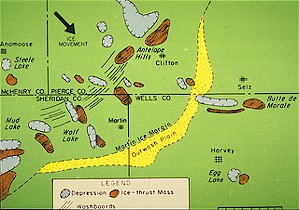
Figure 1. Map of part of central North Dakota showing area where large numbers of ice-thrust hills and associated depressions occur. An area of long drumlins occurs behind (northwest of) the ice thrust blocks.
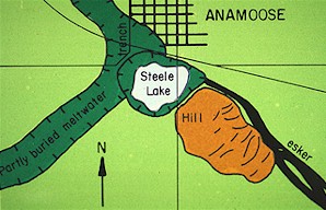
For example, Steele Lake at the town of Anamoose occupies a depression formed about 12,000 years ago when the glacier extracted — lifted or thrust — a chunk of material, moved it as a single piece, and then set it down a tenth of a mile to the southeast. The lake is straight south of Anamoose; the materials that were once where the lake is today form a hill on the southeast edge of the lake (Figs. 2 and 3).
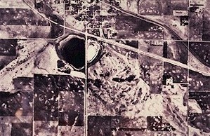
Figure 2. View from the air over the town of Anamoose in southeastern McHenry County. Steele Lake, on the south edge of town, is adjacent to an ice-thrust hill immediately to its southeast. The hill consists of material that was moved by the glacier, southeastward from where the lake is now.
 Figure
3. Map of the same area shown on Figure 2
Figure
3. Map of the same area shown on Figure 2
In the late 1960's, when I first realized how hill-hole combinations like the one at Anamoose formed, I thought it would be appropriate to refer to such a feature as an "anamoose." However, the grammatical problems arising from that name were soon apparent. Are three such hills "anameece?" "anamooses?" simply "anamoose?" (as "I hit three moose on the road"). The name of the town "Anamoose," incidentally, is apparently an adaptation of a Chippewa word (uhnemoosh), meaning female dog. Those people fascinated by unusual place names seem to be very happy with Anamoose. In any event, the difficulties with the word soon led me to switch, simply, to "ice-thrust hills" or "ice-thrust topography."
Areas of ice-thrust topography are found in many places on the plains of North Dakota and throughout the prairie provinces of southern Canada. Several other kinds of ice-thrust landforms have now been recognized in North Dakota, but the hill-hole combinations — roughly equidimensional hills containing thrust masses located downglacier from a source depression of similar size and shape (as at Anamoose) are the most striking.
Briefly, the theory NDGS geologists developed about 30 years ago to explain features like the one at Anamoose is as follows:
 Figure
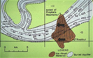
4. Extent of the Prophets Mountains in western Sheridan County, a few miles
northwest of McClusky. The Prophets Mountains occur over a large aquifer which
is contained within the valley of an ancient river.
Figure
4. Extent of the Prophets Mountains in western Sheridan County, a few miles
northwest of McClusky. The Prophets Mountains occur over a large aquifer which
is contained within the valley of an ancient river.
The features tend to be found overlying buried aquifers
(Figs 4 and 5). Aquifers are rock or sediment layers that contain water. An
aquifer might be contained in a bed of permeable sandstone, or it might be developed
in gravel beds that had been deposited by water flowing from the melting ice
("permeable" means that the rock or sediment has interconnected holes
so that water can seep or flow through it). In many cases, the aquifers are
deeply buried, beneath impermeable layers of rock (impermeable means water can't
flow through it). When the glacier advanced over such an aquifer, its weight
sometimes caused elevated pore-water pressures to build up in the beds of sediment
overlying the aquifer. When this happened, the pressure pushed — forced
— the materials upward, into the path of the advancing ice and, as a result,
large, intact blocks of material were incorporated into the advancing glacier.
The situation is kind of analogous to the action of a hydraulic jack. The "jack"
pushed the material upward into the path of the glacier.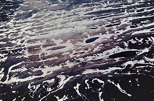
Figure 5. Air view of the Prophets Mountains. These ice-thrust hills consist of slabs of material that were pushed up by the ice from east to west. The snow marks troughs between ice-thrust ridges.
These large blocks of material were moved a short distance — they were "thrust" — by the glacier. The result was a hill (the ice-thrust block) and a hole (the place the block came from) (Fig. 6). Some of the blocks that were moved by this process are truly huge, on the order of a few hundred feet thick and several square miles in area (Fig. 7).
Pressurized groundwater is necessary for thrusting to
occur and in order to build up pressure, something had to confine the water.
If the groundwater was able to escape ahead of an advancing glacier, thrusting
did not occur. If it could not escape, for whatever reason, thrusting was possible.
In some cases, it's likely that a surface layer of frozen ground — permafrost
— contributed to thrusting by acting as a confining layer for the groundwater.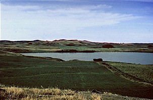
Figure 6. View over a lake, toward the Binford Hills in Griggs County. The lake is contained in the hole that formed when the Binford Hills were thrust by the glacier into their present location.
We have identified several kinds of ice-thrust features,
but the most striking and obvious of those found in North Dakota are the hill-hole
combinations like the one at Anamoose — discrete hills of ice-thrust material,
often slightly crumpled, situated a short distance downglacier from source depressions
of similar size and shape. The source depressions commonly contain lakes or
ponds. A typical ice-thrust hill of this type is about 100 feet high and less
than a mile across. It may be located immediately adjacent to the hole from
which it came or it may be as far as three miles away from it. If the glacier
continued to advance over an area after it had thrust the material, the feature
tended to become smeared out; many ice-thrust features are buried beneath younger
glacial sediment. The best ice-thrust hills are found in places where the glacier
stopped advancing almost as soon as it completed the job of thrusting the materials.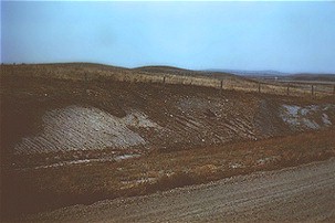
< face="CG Times">Figure 7. Glacially deformed bedrock in a road cut in the Prophets Mountains.
The formation of thrust features like the one near Anamoose might be likened to popping the cork from a bottle of champagne; after the initial release when the thrusting occurred, the groundwater gushed out of the resulting hole and the pressure dissipated. To draw an analogy: the pressure in the bottle (aquifer) was released when the cork (hill) was removed from the bottle. Thus: "North Dakota champagne topography!"
Just a few more examples of thrust features like the one at Anamoose: Egg Lake and Egg Lake Hill southeast of Harvey in Wells County; Medicine Lake and the adjacent Grasshopper Hills north of Jamestown in Stutsman County; Rugh Lake and the adjacent hill in eastern Nelson County; Blue Mountain and the adjacent depression west of Stump Lake in Nelson County — dozens of the features are found in North Dakota. The granddaddy of all ice thrusts is Devils Lake. The materials from the ice-thrust hole that today contains Devils Lake are all piled up along the south side of the lake.
A lot of these kinds of ice thrust features are found in North Dakota, but the features are not common in other states. Why? A partial answer to this question relates to the fact that regional drainage in North Dakota was northward and the glaciers were advancing southward. Thus, the glaciers were advancing against the direction of groundwater flow. The rivers were simply diverted east and south, around the edge of the glacier, but the groundwater couldn't go anywhere.
In any situation in which the groundwater could not easily escape, there was the potential for pressures to build up. For example, if the surface of the ground ahead of an advancing glacier was frozen, this could form an impermeable seal on the surface of the ground. In many parts of central and northern North Dakota, water probably simply became trapped in the bedrock or glacial sediments beneath the ice, increasing the likelihood of thrusting.
Thrusting also occurred in northern Europe, where glaciers advanced southward against the regional groundwater flow systems. On the other hand, in areas where the glaciers advanced in the same direction as the regional groundwater flow systems, as in Scandinavia and the British Isles, very little thrusting occurred. The groundwater was able to escape ahead of the advancing ice.
I suppose it's appropriate that the best champagne topography in the United States is found in North Dakota, the home of Lawrence Welk and his "champagne music!"
Photos by John Bluemle
![]()
| ND Notes Main Page |