[ ]
]
[]
 |
NORTH DAKOTA'S BOUNDARIES by John P. Bluemle |
Introduction
I recently received a letter from a lady in Oklahoma who wondered "Why are the boundaries of your state where they are? Why not a few miles down the road or in some other location? How were they decided?"
The lady may have sent the same letter to every state. I suppose a geographer or historian might know many of the answers to her questions, but I didn't and, I suspect, neither do a lot of other North Dakotans. Nor could I find any kind of reference that included this information all in one place. Geographers I asked couldn't direct me to a specific reference that includes the information.
My goal here is to describe how the boundaries of North Dakota were established, and insofar as I can, I'll try to provide an answer to the questions the lady asked. I'll begin with a general discussion of how geographic boundaries are established and follow with an account of each of North Dakota's four boundaries.
How Geographic Boundaries are Commonly Established
Geographic boundaries are defined, established, and changed in various ways. Three of the most common means of defining jurisdictional boundaries are:. By a water boundary, such as a stream, lake, or other body of water (e.g. North Dakota's eastern boundary - the Red River of the North);
. By a divide between two drainage basins (the boundary between parts of Montana and Idaho);
. By a meridian of longitude or a parallel of latitude (North Dakota's northern, southern, and western boundaries).
The precision of the last of these depends upon the accuracy and ability of the surveyor. Certainly, no doubt exists as to the intent of the wording when a parallel of latitude is specified, because the numbering always begins with zero at the equator. Meridians are more ambiguous. The numbering of meridians increases from zero to the east and west of Greenwich, England, but this has not always been so; even today in some countries, the initial meridian is the one passing through the nation's capital. In the United States, the meridian passing through Washington, D.C., was used as a point of departure from 1850 until 1912. [The Washington meridian passes through the center of the dome of the old Naval Observatory at 24th Street and Constitution Avenue NW, Washington, D.C., which is located 5 hours, 8 minutes, 12.15 seconds or 77°03'02.3" west of Greenwich.] It was during the years when this law was in effect that North Dakota's boundaries were determined. The above-mentioned longitude, 77°03'02.3", became the eventual basis for establishing the line that is the boundary between the states of North Dakota and Montana.
The State of North Dakota
By the enabling act of February 22, 1889, Dakota Territory was divided into two parts, North Dakota and South Dakota:The area comprising the Territory of Dakota shall...be divided on the line of the seventh standard parallel produced due west to the western boundary of said Territory... The enabling act provided for a constitutional convention of 75 members, with three to be elected from each of twenty-five districts. On May 14, in a late blizzard, voters went to the polls in their sleighs to elect the delegates. The convention convened on July 4 in Bismarck and drafted a constitution (for more detailed information on the debates that took place during the convention, see Elwyn Robinson's History of North Dakota). The North Dakota constitution was ratified on October 1, 1889.
The enabling act described the state's boundaries as follows:
"The State of North Dakota shall consist of all the territory included within the following boundaries, to wit: Commencing at a point in the main channel of the Red River of the North, where the forty-ninth degree of north latitude crosses the same, from thence south up the main channel of the same and along the boundary line of the State of Minnesota to a point where the seventh standard parallel intersects the same; thence west along said seventh standard parallel to a point where it intersects the twenty-seventh meridian of longitude west from Washington; then north on said meridian to a point where it intersects the forty-ninth degree of north latitude; thence east along said line to place of beginning." President Benjamin Harrison signed the proclamations admitting the two new states to the Union . There had been some rivalry between the two states for the honor of being the first to be admitted to the Union, but President Harrison declined to settle the issue by making a choice. He had Secretary of State James Blaine shuffle the papers and cover them so he could not tell which proclamation he signed first. The signing took place at 3:40 p.m. on November 2, 1889. Thus, both North and South Dakota were born within the same moment. To sign the proclamations, President Harrison used a pen fashioned from the quill of an eagle that had been shot in the northern part of Dakota Territory.
The Modern Boundaries of North Dakota
Even though Congressional definitions of the boundaries of the various states may have specified that they follow certain parallels or meridians, some discrepancies and apparent errors in the locations of state boundaries remain. The reason for the discrepancies is that the actual measurement and demarcation of the boundaries in the field, at the time they were established in the 1800s, was difficult, despite the best intentions of the surveyors. Terrain conditions varied greatly and surveying equipment was primitive. Later re-surveys may have determined that lines that had been surveyed earlier may not have been straight or they may have otherwise been slightly inaccurate.The Northern Boundary of North Dakota
The International Boundary between North Dakota and Manitoba and Saskatchewan, along the 49th parallel of latitude, is 310.0 miles long. The choice of the 49th parallel probably stems from early treaties between the U.S. and Great Britain. The Treaty of Ghent in 1814 and the follow-up Treaty of Peace in 1818 resulted in an agreement to establish a boundary line west from the Lake of the Woods along the 49th parallel.The 1818 convention with Great Britain extended the northern United State's boundary line westward along the 49th parallel of latitude to the "Stony" (Rocky) Mountains and provided that the country beyond these mountains should for 10 years remain open to both parties.
Article II of the Convention reads as follows:
"Article II. It is agreed that a line drawn from the most northwestern part of the Lake of the Woods, along the forty-ninth parallel of north latitude, or if the said point shall not be in the forty-ninth parallel of nonlatitude, then that a line drawn from the said point due north or south, as the case may be, until the said line shall intersect the said parallel of north latitude, and from the point of such intersection due west along and with the said parallel shall be the line of demarcation between the territories of the United States, and those of His Britannic Majesty, and that the said line shall form the northern boundary of the said territories of the United States, and the southern boundary of the territories of His Britannic Majesty, from the Lake of the Woods to the Stony Mountains." The initial point of this boundary, which the convention fixed as "the most northwestern point" of the Lake of the Woods, was selected in 1824 by Dr. J. L. Tiarks, astronomer, and David Thompson, surveyor, who were employed by the British Government for this purpose. The point selected was about 27.5 miles north of the 49th parallel in a swamp.
The result of the Convention of 1818, as it concerns North Dakota, was that it added the area drained by the Red River of the North, south of the 49th parallel of latitude. This area was not part of the Louisiana Purchase (because it was not drained by the Mississippi/Missouri Rivers) and was not considered to be part of the United States (until the Convention of 1818).
In 1823, Major Stephen H. Long established and marked a point at Pembina, which he reported to be on the 49th parallel. However, the point established by Long was later reported by a military commission to be more than 4,600 feet south of the true 49th parallel. This was important to the people of the Pembina, area, a relatively populated area, as the people needed to know which country they lived in.
On March 13, 1872, a bill was passed providing for a commission to establish and mark the International Boundary. The commission met in 1872 and established an astronomical station on the west bank of the Red River. From this point, the line was run west. The International Boundary was first surveyed and marked during the years 1872 - 1875 by surveyors of a United States and British boundary commission. From the Red River of the North to a point on the boundary two miles west of the 99th Meridian (northwest of Sarles, Cavalier County, North Dakota), the boundary was originally marked with cast-iron posts five feet high, set one mile apart along the line. From that point to the western boundary of North Dakota, the line was originally marked either with stone cairns or earth mounds, 10 to 16 feet in diameter, 5 to 8 feet high, erected about three miles apart along the line.
Under a treaty between the United States and Great Britain, signed in Washington, April 11, 1908, the boundary was re-surveyed and re-marked in 1910 and 1911. Along the section of the line to the 99th Meridian, the original cast-iron posts were reset in concrete bases and elsewhere, the stone cairns and earth mounds were replaced with new cast-iron posts, set in concrete bases, as well as placing similar intermediate monuments on the line between the original marks that had been set at three-mile intervals.
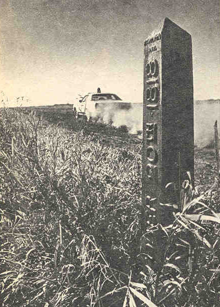
U.S.- Canada boundary. Metal monument at the International Boundary, U.S. side, view to the west-northwest (car is heading west, in Canada). The monuments are inscribed “October 20, 1818” on the U.S. side and “Convention of London” on the Canadian side. Photo is from the October 28, 1973 edition of the Minneapolis Tribune and is provided courtesy of David L. Mercer, United States Border Patrol. The International Boundary posts are inscribed "Convention of London" on the Canadian side and " October 20, 1818 " on the American side.
The Eastern Boundary of North Dakota
The boundary between North Dakota and Minnesota, the thread of the channels of the Red River of the North and the Bois de Sioux River, is approximately 434 miles long. The "as-the-crow-flies" distance is about 213 miles. The difference in the two mileage figures - the river distance being more than double the straight-line distance - is a result of the highly meandering route of the Red River and, to a lesser extent, the Bois de Sioux River.The enabling legislation for the State of Minnesota included the following passage:
"Beginning at the point in the center of the main channel of the Red River of the North, where the boundary line between the United States and British Possessions crosses the same; thence up the main channel of said river to that of the Bois de Sioux River; then [up] the main channel of said river to Lake Traverse ...." The language provided during the constitutional convention for North Dakota reads a little differently: "...commencing at a point in the main channel of the Red River of the North, where the forty-ninth degree of north latitude crosses the same, from thence south up the main channel of the same and along the boundary line of the State of Minnesota to a point where the seventh standard parallel intersects the same; thence west...."
Red River of the North. The extremely sinuous course of the river, as it wends its way northward between North Dakota and Minnesota, more than doubles the length of the distance of the boundary between the two states (compared to the straight-line distance). North Dakota - Minnesota boundary. Sorlie Bridge across the Red River of the North at Grand Forks, ND - East Grand Forks, MN. The view is downstream, with Grand Forks, North Dakota on the left. The Sorlie Bridge was named for North Dakota Governor Arthur Sorlie of Grand Forks and dedicated in 1929. Photo by John Bluemle. The North Dakota language omits any reference to the Bois de Sioux River. Since the Red River does not extend all the way southward to the South Dakota border, it would seem that the failure to reference the Bois de Sioux River is a minor omission. The desired result is obtained by reference to the western "boundary line of the State of Minnesota ".
The Southern Boundary of North Dakota
[Note: By far the best and most complete discussion of the establishing and marking of the boundary between North and South Dakota is that of Gordon Iseminger, "The Quartzite Border," published in 1988 (see references). My abbreviated discussion here is taken largely from Iseminger's book - JPB].The boundary between North and South Dakota follows an east-west line, the Seventh Standard Parallel. The boundary is 360.57 miles long, as surveyed by Charles H. Bates of Yankton, South Dakota, during the summers of 1891 and 1892.
Initially, the boundary line dividing Dakota Territory into two states would have been set at the forty-sixth parallel of north latitude in a bill introduced in 1880 in the United States House of Representatives by Granville G. Bennett, the territorial delegate to Congress. However, northern Dakota Territory people attending a public meeting in Fargo on December 5, 1880, objected to making the forty-sixth parallel the boundary between the two states. A division along this line would have placed five-sixths of the lower tier of townships in Emmons, Logan, LaMoure, Ransom, and Richland counties on the South Dakota side of the boundary, resulting in a loss to North Dakota of large amounts of land. Not only would locating the boundary on the forty-sixth parallel have required a considerable redefining of already-established county boundaries, it would have resulted in homestead claims and improved farms being divided by the state boundary.
To avoid the confusion resulting from a division of the territory along the line of the forty-sixth parallel, the Fargo convention resolved in favor of dividing the territory along the line of the Seventh Standard Parallel. This line conformed to the county boundaries already established and to the township lines already drawn by congressional survey. Bennett's bill was eventually pigeonholed and, when the Enabling Act for the Dakotas, Montana, and Washington was passed, it stipulated that the Territory of Dakota should be "divided on the line of the Seventh Standard Parallel ..."
The Seventh Standard Parallel. The simple designation of the Seventh Standard Parallel as the boundary between the two states did not solve all the problems. Contrary to common assumption, the Seventh Standard Parallel was not a simple straight line from the eastern boundary of the territory to the Missouri River. In fact, there were two Seventh Standard Parallels in Dakota Territory prior to statehood. Both were well defined and the Interior Department in Washington had endorsed and reported on both of them.
The confusion regarding the location of the Seventh Standard Parallel arose because of a mistake made in the office of the Minnesota surveyor general. It had been intended to base the survey of the Seventh Standard Parallel across the Sisseton and Wahpeton Indian Reservation on the eastern edge of the territory on the fifth principal meridian base. Unfortunately, a critical reference had been written as "miles and chains" in the Minnesota office, when it should have been written as "chains and links". Consequently, the Seventh Standard Parallel across the reservation was drawn about two and a quarter miles south of where it should have been.
If the Seventh Standard Parallel were to have been "extended due west" from this point to the Montana boundary, a considerable amount of territory would have been involved, and endless uncertainty, litigation, and hard feelings would have resulted. More tempered accounts held that the Seventh Standard Parallel was a clearly defined line, except where it crossed the Sisseton and Wahpeton Indian Reservation.
Because of the confusion, the location of the Seventh Standard Parallel had to be clarified. People living along the line had to know to which state they paid taxes. The location of the boundary was also a concern for the federal government. The proposed boundary would pass through such federal jurisdictions as Indian reservations, judicial districts, land office districts, and postal districts. As reported in the New York Times on March 5, 1889, national attention was focused on the location of the elusive Seventh Standard Parallel.
North Dakota and South Dakota appointed a Joint Commission to determine the location of the Seventh Standard Parallel. But, when the Commission was unable to accomplish this, the matter was turned over to the federal government to act. The state boundary had to be determined, surveyed, fixed, and marked as quickly as possible, and the boundary, once fixed, had to be one that everyone could accept.
After a contentious debate, Senate Bill 3089 was signed into law on September 25, 1890. It provided that the United States Secretary of the Interior would oversee the survey of the Seventh Standard Parallel from the Minnesota border on the east to the Montana border on the west.
Definition of the Seventh Standard Parallel. The Seventh Standard Parallel North of the public land survey is an extension from the Minnesota survey. The baseline in Minnesota is the Iowa-Minnesota border and the Standard Parallels in both Minnesota and North Dakota (and eastern South Dakota) are numbered from the northern border of Iowa. The distance between the Standard Parallels, measured from south to north, is 24 miles. The Standard Parallels in both Minnesota and North Dakota are numbered (northward) from the Iowa-Minnesota border. Thus, the southern border of North Dakota is referenced to the Iowa-Minnesota border, and is 168 miles north of that line (7 x 24 =168 miles). The Seventh Standard Parallel is considered to be at 45°56'07" North Latitude.
Surveying and Marking the Boundary Between North and South Dakota. On June 4, 1891, Charles Bates signed a contract to survey and install monuments along the boundary. Bates marked the boundary with quartzite monuments quarried at Sioux Falls, South Dakota. The monuments were seven feet long and ten inches square at the top and were set at half-mile intervals. Each monument was marked with the initials "N.D." on the north side and "S.D." on the south side. Mile monuments were marked with the number of miles from the initial monument (from the east) on the east side of the post. The intermediate mile posts - section line corners - were marked on their north side with the letters "S.C." (section corner) below the "N.D." and the numbers of the township and range. The first monument was located 9 chains west of the Bois de Sioux River bed along the Seventh Standard Parallel.
It was not possible to be exactly accurate during the surveying process. Thus, the latitude of the Seventh Standard Parallel, near where it crosses the Bois de Sioux River is surveyed as being at a latitude of 45°56'07" North. At the western end of the state boundary, where it intersects the Montana boundary, it is at 45°56'43". This is a discrepancy of 36 seconds. Therefore, the boundary between the states of North and South Dakota is about 3,660 feet farther north on the west end than on the east.
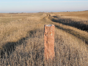
Even though it is illegal to disturb the markers, many of them have suffered in various ways since they were installed. Some have been altered, destroyed, removed, or defaced. Some have been damaged by farm machinery. Some have been toppled by erosion. Some have been used as fence posts and others as cattle rubbing stones. In fact, when Bates had completed the survey and marking of the boundary, he told the editor of the Sturgis Weekly Record that his having erected 720 superb cattle-scratching posts qualified him for membership in the Humane Society of the United States. Some monuments are now used as handy posts for "No Hunting" or "No Trespassing" signs. Mile Post 51 is a lawn ornament on a farmstead near Havana, North Dakota (about a mile north of the state line); Mile Post 91 is located in front of the Great Plains Museum near Mandan; two monuments stand on either side of a sidewalk leading to a house in Garrison, North Dakota. It should be noted that these North Dakota - South Dakota boundary. Quartzite monument on the North Dakota-South Dakota state line at approximately mile 166½ measured from the Red River. This monument is located south of the town of Hague on the Emmons-Campbell county line. The view is to the east, with North Dakota on the left. Photo by John Bluemle.
and other monuments were not necessarily moved illegally. One monument, Mile Post 169, was broken off when it was hit by a running horse (the fate of the horse is not known).
The Western Boundary of North Dakota
The western boundary of North Dakota is approximately 210.95 miles long (calculated by a modern geographic information system). The survey of the eastern boundary of Montana (the western boundary of North Dakota and much of South Dakota) on the 27th meridian west of Washington, D.C. was undertaken in 1885. Surveying was initiated by astronomical observations at Mingusville (now Wibaux), Montana, by Daniel G. Major, U.S. Surveyor.North Dakota - Montana boundary. There is some uncertainty as to the exact location of the boundary. (A) The photo shows a farmstead on the Montana state line about six miles south of Beach. The buildings are in North Dakota, the fence row (along the right side of the bushes) is the state line at approximately 104° 02' 50" (as determined by a GPS receiver). (B) The photo shows the at this location. This photo shows a view of a road, but located about 820 feet farther west than the location shown in (A). The longitude of this line is approximately 104° 03' 02.3", which is just about what it “should” be (27° + 77° 03' 02.3" - see text). Photos by William J. Bluemle. The initial position was established by measurement from an astronomical station on the Northern Pacific Railway six miles and 28.51 chains to the west, where an exchange of time signals had been made by telegraph. From the point thus found, a random line was run south to the 45th parallel. The markers, were established at one-mile intervals and constructed of either stone or native wood (cottonwood, elm, or pine).
The first mention of the 27th meridian as a boundary line is in the enabling act for Idaho Territory in 1863; it marked the eastern boundary of Idaho Territory. The 27th meridian was not mentioned in the Organic Act for Dakota Territory because the original Dakota Territory extended beyond and included that line. Then, when the acts designating the states of North and South Dakota were written, they included the Idaho Territory language specifying the 27th meridian as the western boundary of the two new states.
I am unsure just why the 27th meridian was chosen as the boundary between the two Dakotas and Montana and Wyoming. It may have been a number chosen "out of the blue" at the time Idaho Territory was established. The line does not coincide with any particular section or half-section line, or anything else of local or regional significance.
As I noted, the boundary line was not intended to follow the 104th degree of west longitude, but rather it was placed on the 27th meridian west of Washington. The boundary between North Dakota and Montana is supposed to be at 104°03'02.3" (27° + 77°03'02.3"), and it is supposed to be a straight north-south line. However, a study of 7.5 minute topographic maps shows that the North Dakota - Montana boundary is at 104°02'46" at the South Dakota state line and at 104°02'54" at the International Boundary. That is, on the north end the boundary is approximately 533 feet farther west than it is on the south end.
Map of the United States (apart from Alaska and Hawaii), showing the accessions of territory from 1803 to 1853. North Dakota consists of land acquired by the Louisiana Purchase in 1803 and from Great Britain in1818.
References
Iseminger, G. L., 1988. The quartzite border: surveying and marking the North Dakota-South Dakota boundary 1891 - 1892: The Center for Western Studies, Augustana College, Sioux Falls, South Dakota, 122 p.Kastelle, Russell E., (no date). Meridians, base lines, parallels, townships, ranges and sections in North Dakota; unpublished manuscript.
Kane, L. M., Holmquist, J. D., and Gilman, Carolyn, 1978. The northern expeditions of Stephen H. Long - the journals of 1817 and 1823 and related documents: Minnesota Historical Society Press, pp 1 - 46.
Mercer, David L., 2002. Personal communication and photo.
Organic Act of Dakota Territory, March 2, 1861, reprinted from the South Dakota Historical Review, vol. 1, no. 2, January 1936.
Robinson, E. B., 1966. History of North Dakota: University of Nebraska Press, 610 p.
Van Zandt, F. K., 1976. Boundaries of the United States and the several states: United States Geological Survey Professional Paper 909, 191 p.
White, James, 1914. Boundary disputes and treaties: Toronto, 958 p.
Copyright © 2002 North Dakota Geological Survey
Last modified:
20-Jul-2007